Tour Wandern Gisors - Gisors - Voie verte - Photo

Gisors - Voie verte

 marcel.F
marcel.F

Benutzer

© OpenStreetMap contributors
Länge
Länge
10,4 km
Maximale Höhe
Maximale Höhe
97 m
Positive Höhendifferenz
109 m
Km-Effort
Km-Effort  
11,9 km
Min. Höhe
Min. Höhe
43 m
Negative Höhendifferenz
109 m
Boucle
Boucle
Ja
Erstellungsdatum :
2016-06-07 00:00:00.0
Letzte Änderung :
2019-04-10 14:34:08.034

(0 Nachricht)

Wandern
Wandern
2h36
Schwierigkeit : Einfach

Scannen Sie diesen QR-Code, um die Tour in der SityTrail-Anwendung zu öffnen

Kostenlosegpshiking-Anwendung

Logo SityTrail SityTrail

IGN / Geografische Institute

SityTrail aus dem App Store herunterladen SityTrail von Google Play herunterladen

Logo SityTrail SityTrail World

Die Welt öffnet sich für Sie

SityTrail aus dem App Store herunterladen SityTrail von Google Play herunterladen SityTrail auf Huawei AppGallery herunterladen

Über SityTrail

Tour Wandern von 10,4 km verfügbar auf Normandie, Eure, Gisors. Diese Tour wird von marcel.F vorgeschlagen.

Beschreibung

Boucle au départ parking accès voie verte depuis rond-point près Intermarché à Gisors
via voie verte et Mauréaumont

Höhenprofil

Ort

Land:
France
Region :
Normandie
Abteilung/Provinz :
Eure
Kommune :
Gisors
Standort:
Unknown
Gehen Sie:(UTM)
410004 ; 5458730 (31U) N.

Touren in der Umgebung

Tour Wandern Delincourt - Delincourt, Le Mesnil, Reilly, La vierge, Delincourt - Photo
Wandern
Marie-Claire-mcp

Wandern

Medium
(1)
Delincourt, Nordfrankreich, Oise, France
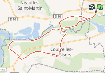
8,7 km | 10,4 km-effort
2h 16min
Ja
Tour Wandern Boury-en-Vexin - Boury en Vexin - Hérouval - Photo
Wandern
marcel.F

Wandern

Einfach
(3)
Boury-en-Vexin, Nordfrankreich, Oise, France
10,9 km | 12,9 km-effort
2h 49min
Ja
Tour Wandern Vaudancourt - Vaudancourt - Breuil et Boury - Photo
Wandern
marcel.F

Wandern

Einfach
(1)
Vaudancourt, Nordfrankreich, Oise, France
11,8 km | 14,3 km-effort
3h 5min
Ja
Tour Wandern Bézu-Saint-Éloi - Bézu Saint Eloi - Départ du parking route de Gisors (place St Eloi), puis Neaufles St martin - Photo
Wandern
Marie-Claire-mcp

Wandern

Medium
(1)
Bézu-Saint-Éloi, Normandie, Eure, France
10,3 km | 12 km-effort
2h 43min
Ja
Tour Nordic Walking Bézu-Saint-Éloi - Marche Nordique 89  Bezu Saint Eloi - Photo
Nordic Walking
marcel.F

Nordic Walking

Einfach
(1)
Bézu-Saint-Éloi, Normandie, Eure, France
8,6 km | 10 km-effort
1h 30min
Ja
Tour Nordic Walking Boury-en-Vexin - Marche Nordique 75 Boury en Vexin - Photo
Nordic Walking
marcel.F

Nordic Walking

Einfach
(1)
Boury-en-Vexin, Nordfrankreich, Oise, France
10,3 km | 12,6 km-effort
1h 30min
Ja
Tour Nordic Walking Courcelles-lès-Gisors - Marche Nordique 71 Courcelles les Gisors - Photo
Nordic Walking
marcel.F

Nordic Walking

Sehr leicht
(2)
Courcelles-lès-Gisors, Nordfrankreich, Oise, France
9,2 km | 10,9 km-effort
1h 26min
Ja
Tour Wandern Chambors - CHAMBORS - Lattainville-Delincourt-Reillly - Photo
Wandern
marcel.F

Wandern

Sehr leicht
(1)
Chambors, Nordfrankreich, Oise, France
12,3 km | 15,2 km-effort
2h 54min
Ja
Tour Nordic Walking Chambors - Marche Nordique 61 Chambors - Photo
Nordic Walking
marcel.F

Nordic Walking

Einfach
(1)
Chambors, Nordfrankreich, Oise, France
8,4 km | 10,3 km-effort
1h 30min
Ja


Schließen
Meine Abonnements