Tour Wandern Val-au-Perche - L hermitiere - Photo
 dom2691
dom2691

Benutzer

© OpenStreetMap contributors
Länge
Länge
3,5 km
Maximale Höhe
Maximale Höhe
185 m
Positive Höhendifferenz
89 m
Km-Effort
Km-Effort  
4,6 km
Min. Höhe
Min. Höhe
119 m
Negative Höhendifferenz
55 m
Boucle
Boucle
Nein
Erstellungsdatum :
2019-04-04 06:28:04.947
Letzte Änderung :
2019-04-04 12:09:30.077

(0 Nachricht)

Wandern
Wandern
26m
Schwierigkeit : Sehr leicht

Scannen Sie diesen QR-Code, um die Tour in der SityTrail-Anwendung zu öffnen

Kostenlosegpshiking-Anwendung

Logo SityTrail SityTrail

IGN / Geografische Institute

SityTrail aus dem App Store herunterladen SityTrail von Google Play herunterladen

Logo SityTrail SityTrail World

Die Welt öffnet sich für Sie

SityTrail aus dem App Store herunterladen SityTrail von Google Play herunterladen SityTrail auf Huawei AppGallery herunterladen

Über SityTrail

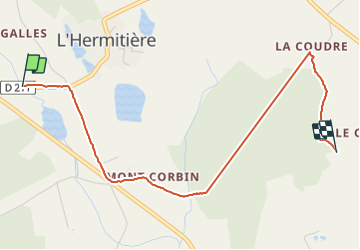
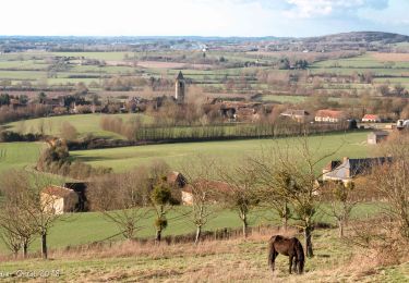
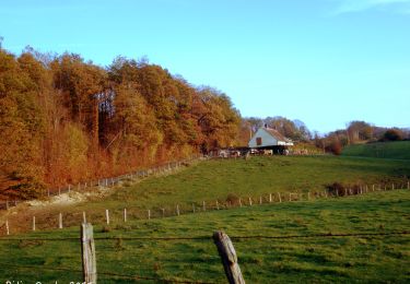
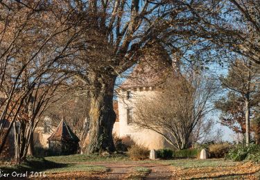
Tour Wandern von 3,5 km verfügbar auf Normandie, Orne, Val-au-Perche. Diese Tour wird von dom2691 vorgeschlagen.

Beschreibung

L hermitiere

Höhenprofil

Ort

Land:
France
Region :
Normandie
Abteilung/Provinz :
Orne
Kommune :
Val-au-Perche
Standort:
Le Theil
Gehen Sie:(UTM)
324677 ; 5349986 (31U) N.

Touren in der Umgebung

Tour Wandern Val-au-Perche - Le Theil-sur-Huisne (Val-au-Perche)-Saint-Germain-de-la-Coudre - 7,4 Km - Photo
Wandern

Wandern

Medium
Val-au-Perche, Normandie, Orne, France
7,4 km | 9,6 km-effort
2h 3min
Nein
Tour Wandern Val-au-Perche - Gémages - Igé 15 km - Photo
Wandern

Wandern

Einfach
Val-au-Perche, Normandie, Orne, France
14,7 km | 17,5 km-effort
7h 2min
Nein
Tour Wandern Val-au-Perche - Gémages - Igé via Appenai-sous-Bellême 17 km - Photo
Wandern

Wandern

Einfach
Val-au-Perche, Normandie, Orne, France
16,7 km | 19,4 km-effort
55min
Nein
Tour Wandern Val-au-Perche - Gémages - Saint-Cyr-la-Rosière 11 km - Photo
Wandern

Wandern

Einfach
Val-au-Perche, Normandie, Orne, France
11,2 km | 13,8 km-effort
2h 37min
Nein
Tour Wandern Val-au-Perche - Le Theil-sur-Huisne (Val-au-Perche) - Saint-Cyr-la-Rosière 11 km - Photo
Wandern

Wandern

Einfach
Val-au-Perche, Normandie, Orne, France
11,2 km | 13,6 km-effort
2h 52min
Nein
Tour Wandern Val-au-Perche - Gémages - Le-Theil-sur-Huisne (Val-au-Perche) 9,3 km - Photo
Wandern

Wandern

Einfach
Val-au-Perche, Normandie, Orne, France
9,3 km | 12,3 km-effort
2h 19min
Nein
Tour Wandern Saint-Germain-de-la-Coudre - St Germain de la Coudre 18 - Photo
Wandern
togolo28

Wandern

Medium
(1)
Saint-Germain-de-la-Coudre, Normandie, Orne, France
18 km | 22 km-effort
4h 42min
Ja
Tour Wandern Val-au-Perche - Gémages -  Préaux-du-Perche 14 km - Photo
Wandern

Wandern

Einfach
Val-au-Perche, Normandie, Orne, France
14,4 km | 17,4 km-effort
10min
Nein
Tour Wandern Val-au-Perche - [Itinéraire] La forêt de Trahant - Photo
Wandern
ODDAD78

Wandern

Schwierig
Val-au-Perche, Normandie, Orne, France
10,9 km | 13,9 km-effort
3h 9min
Ja


Schließen
Meine Abonnements