Tour Wandern Saint-Christophe-sur-Avre - 10734865-St Christophe sur Avre 16.29 - Photo

10734865-St Christophe sur Avre 16.29

 togolo28
togolo28

Benutzer

© OpenStreetMap contributors
Länge
Länge
16,7 km
Maximale Höhe
Maximale Höhe
221 m
Positive Höhendifferenz
145 m
Km-Effort
Km-Effort  
18,6 km
Min. Höhe
Min. Höhe
179 m
Negative Höhendifferenz
147 m
Boucle
Boucle
Ja
Erstellungsdatum :
2019-11-22 17:29:21.414
Letzte Änderung :
2019-12-01 14:13:44.864

(0 Nachricht)

Wandern
Wandern
--
Schwierigkeit : Medium

Scannen Sie diesen QR-Code, um die Tour in der SityTrail-Anwendung zu öffnen

Kostenlosegpshiking-Anwendung

Logo SityTrail SityTrail

IGN / Geografische Institute

SityTrail aus dem App Store herunterladen SityTrail von Google Play herunterladen

Logo SityTrail SityTrail World

Die Welt öffnet sich für Sie

SityTrail aus dem App Store herunterladen SityTrail von Google Play herunterladen SityTrail auf Huawei AppGallery herunterladen

Über SityTrail

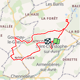
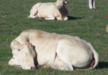
Tour Wandern von 16,7 km verfügbar auf Normandie, Eure, Saint-Christophe-sur-Avre. Diese Tour wird von togolo28 vorgeschlagen.

Höhenprofil

Ort

Land:
France
Region :
Normandie
Abteilung/Provinz :
Eure
Kommune :
Saint-Christophe-sur-Avre
Standort:
Unknown
Gehen Sie:(UTM)
339305 ; 5396411 (31U) N.

Touren in der Umgebung

Tour Wandern Chennebrun - Circuit des Normands - Chennebrun - Photo
Wandern
tracegps

Wandern

Einfach
Chennebrun, Normandie, Eure, France
5,5 km | 5,9 km-effort
1h 19min
Ja
Tour Fahrrad Les Barils - Circuit découverte de villages normands - Les Barils - Photo
Fahrrad
tracegps

Fahrrad

Einfach
Les Barils, Normandie, Eure, France
17,9 km | 19,7 km-effort
1h 15min
Ja
Tour Wandern Les Barils - ballade autour de center parc les bois franc - Photo
Wandern
franckaille

Wandern

Sehr leicht
Les Barils, Normandie, Eure, France
12,9 km | 14,1 km-effort
2h 7min
Nein
Tour Wandern Saint-Christophe-sur-Avre - Les Fossés Royaux - St Christophe-sur-Avre - Photo
Wandern
tracegps

Wandern

Einfach
Saint-Christophe-sur-Avre, Normandie, Eure, France
7,2 km | 8 km-effort
1h 49min
Ja
Tour Wandern Gournay-le-Guérin - Circuit des Fermes -  Gournay-le-Guérin  - Photo
Wandern
tracegps

Wandern

Einfach
Gournay-le-Guérin, Normandie, Eure, France
7,3 km | 7,9 km-effort
1h 49min
Ja
Tour Wandern Chennebrun - Circuit des Normands - Chennebrun  - Photo
Wandern
tracegps

Wandern

Einfach
Chennebrun, Normandie, Eure, France
5,5 km | 5,9 km-effort
1h 19min
Ja
Tour Wandern Saint-Christophe-sur-Avre - st Christophe - Photo
Wandern
bipf

Wandern

Sehr leicht
Saint-Christophe-sur-Avre, Normandie, Eure, France
510 m | 556 m-effort
15min
Nein
Tour Wandern Pullay - Pullay Bois Francs 10.1 Km - Photo
Wandern
ODDAD78

Wandern

Einfach
Pullay, Normandie, Eure, France
10,1 km | 11 km-effort
2h 27min
Ja
Tour Wandern Gournay-le-Guérin - Gournay le Guerin  - Photo
Wandern
DranoelNiala

Wandern

Einfach
Gournay-le-Guérin, Normandie, Eure, France
8,3 km | 9,1 km-effort
2h 8min
Ja


Schließen
Meine Abonnements