Tour Zu Fuß Pont-d'Ouilly - pont d'ouilly grand c - Photo

pont d'ouilly grand c

 doboul
doboul

Benutzer

© OpenStreetMap contributors
Länge
Länge
7,9 km
Maximale Höhe
Maximale Höhe
207 m
Positive Höhendifferenz
220 m
Km-Effort
Km-Effort  
10,9 km
Min. Höhe
Min. Höhe
48 m
Negative Höhendifferenz
220 m
Boucle
Boucle
Ja
Erstellungsdatum :
2020-09-26 14:01:19.495
Letzte Änderung :
2020-09-26 14:01:49.266

(0 Nachricht)

Zu Fuß
Zu Fuß
--
Schwierigkeit : Medium

Scannen Sie diesen QR-Code, um die Tour in der SityTrail-Anwendung zu öffnen

Kostenlosegpshiking-Anwendung

Logo SityTrail SityTrail

IGN / Geografische Institute

SityTrail aus dem App Store herunterladen SityTrail von Google Play herunterladen

Logo SityTrail SityTrail World

Die Welt öffnet sich für Sie

SityTrail aus dem App Store herunterladen SityTrail von Google Play herunterladen SityTrail auf Huawei AppGallery herunterladen

Über SityTrail

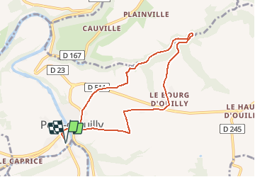
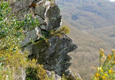
Tour Zu Fuß von 7,9 km verfügbar auf Normandie, Calvados, Pont-d'Ouilly. Diese Tour wird von doboul vorgeschlagen.

Höhenprofil

Ort

Land:
France
Region :
Normandie
Abteilung/Provinz :
Calvados
Kommune :
Pont-d'Ouilly
Standort:
Unknown
Gehen Sie:(UTM)
689842 ; 5416392 (30U) N.

Touren in der Umgebung

Tour Mountainbike Pont-d'Ouilly - La Petite Suisse Normande 2014 - Pont-d'Ouilly - Photo
Mountainbike
tracegps

Mountainbike

Schwierig
(1)
Pont-d'Ouilly, Normandie, Calvados, France
41 km | 54 km-effort
3h 30min
Ja
Tour Wandern Saint-Philbert-sur-Orne - Autour des roches d'oetre - Photo
Wandern
phi14

Wandern

Einfach
(3)
Saint-Philbert-sur-Orne, Normandie, Orne, France
9,7 km | 12,4 km-effort
2h 30min
Ja
Tour Wandern Saint-Philbert-sur-Orne - Roche d’oëtre sentier du Granite - Photo
Wandern
zefreefly

Wandern

Sehr leicht
Saint-Philbert-sur-Orne, Normandie, Orne, France
10,1 km | 12,7 km-effort
2h 43min
Ja
Tour Wandern Le Vey - Clécy - Photo
Wandern
zefreefly

Wandern

Einfach
Le Vey, Normandie, Calvados, France
14,8 km | 20 km-effort
3h 51min
Ja
Tour Wandern Saint-Philbert-sur-Orne - Circuit des méandres  - Photo
Wandern
JLPIERSON

Wandern

Medium
Saint-Philbert-sur-Orne, Normandie, Orne, France
6,4 km | 8,4 km-effort
1h 54min
Ja
Tour Wandern Ménil-Hubert-sur-Orne - De Rouvroy aux Roches d'Oetre par le sentier des Méandres  - Photo
Wandern
Ecureuiltrailer

Wandern

Medium
Ménil-Hubert-sur-Orne, Normandie, Orne, France
7,1 km | 9,3 km-effort
2h 1min
Ja
Tour Zu Fuß Saint-Philbert-sur-Orne - Entre Orne et Rouvre - Photo
Zu Fuß
PRO

Zu Fuß

Einfach
Saint-Philbert-sur-Orne, Normandie, Orne, France
7,7 km | 10,3 km-effort
2h 19min
Ja
Tour Zu Fuß Pont-d'Ouilly - Circuit du Val la Hère - Photo
Zu Fuß
PRO

Zu Fuß

Einfach
Pont-d'Ouilly, Normandie, Calvados, France
6,7 km | 9,4 km-effort
2h 7min
Ja
Tour Zu Fuß Le Bô - Des Montagnes de Normandie? - Photo
Zu Fuß
PRO

Zu Fuß

Medium
Le Bô, Normandie, Calvados, France
15,4 km | 20 km-effort
4h 38min
Nein


Schließen
Meine Abonnements