Tour Wandern Unknown - w-schotland-great-glen-way - Photo

w-schotland-great-glen-way

 gpstracks
gpstracks

Benutzer

© OpenStreetMap contributors
Länge
Länge
210 km
Maximale Höhe
Maximale Höhe
382 m
Positive Höhendifferenz
2606 m
Km-Effort
Km-Effort  
245 km
Min. Höhe
Min. Höhe
-1 m
Negative Höhendifferenz
2607 m
Boucle
Boucle
Ja
Erstellungsdatum :
2014-12-10 00:00:00.0
Letzte Änderung :
2014-12-10 00:00:00.0

(0 Nachricht)

Wandern
Wandern
--
Schwierigkeit : Unbekannt

Scannen Sie diesen QR-Code, um die Tour in der SityTrail-Anwendung zu öffnen

Kostenlosegpshiking-Anwendung

Logo SityTrail SityTrail

IGN / Geografische Institute

SityTrail aus dem App Store herunterladen SityTrail von Google Play herunterladen

Logo SityTrail SityTrail World

Die Welt öffnet sich für Sie

SityTrail aus dem App Store herunterladen SityTrail von Google Play herunterladen SityTrail auf Huawei AppGallery herunterladen

Über SityTrail

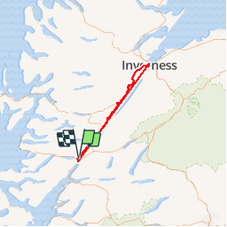
Tour Wandern von 210 km verfügbar auf Schottland, Highland. Diese Tour wird von gpstracks vorgeschlagen.

Beschreibung

More information on GPStracks.nl : http://www.gpstracks.nl

Höhenprofil

POIs

POI  - 001GGW - Photo
gpstracks
POI  - 002GGW - Photo
gpstracks
POI  - 003GGW - Photo
gpstracks
POI  - 004GGW - Photo
gpstracks
POI  - 005GGW - Photo
gpstracks
POI  - 006GGW - Photo
gpstracks
POI  - 007GGW - Photo
gpstracks
POI  - 008GGW - Photo
gpstracks
POI  - 009GGW - Photo
gpstracks
POI  - 010GGW - Photo
gpstracks
POI  - 011GGW - Photo
gpstracks
POI  - 012GGW - Photo
gpstracks
POI  - 013GGW - Photo
gpstracks
POI  - 014GGW - Photo
gpstracks
POI  - 015GGW - Photo
gpstracks
POI  - 016GGW - Photo
gpstracks
POI  - 017GGW - Photo
gpstracks
POI  - 018GGW - Photo
gpstracks
POI  - 019GGW - Photo
gpstracks
POI  - 020GGW - Photo
gpstracks
POI  - 021GGW - Photo
gpstracks
POI  - 022GGW - Photo
gpstracks
POI  - 023GGW - Photo
gpstracks
POI  - 024GGW - Photo
gpstracks
POI  - 025GGW - Photo
gpstracks
POI  - 026GGW - Photo
gpstracks
POI  - 027GGW - Photo
gpstracks
POI  - 028GGW - Photo
gpstracks
POI  - 029GGW - Photo
gpstracks
POI  - 030GGW - Photo
gpstracks
POI  - 031GGW - Photo
gpstracks
POI  - 032GGW - Photo
gpstracks
POI  - 033GGW - Photo
gpstracks
POI  - 034GGW - Photo
gpstracks
POI  - 035GGW - Photo
gpstracks
POI  - 036GGW - Photo
gpstracks
POI  - 037GGW - Photo
gpstracks
POI  - 038GGW - Photo
gpstracks
POI  - 039GGW - Photo
gpstracks
POI  - 040GGW - Photo
gpstracks
POI  - 041GGW - Photo
gpstracks
POI  - 042GGW - Photo
gpstracks
POI  - 043GGW - Photo
gpstracks
POI  - 044GGW - Photo
gpstracks
POI  - 045GGW - Photo
gpstracks
POI  - 046GGW - Photo
gpstracks
POI  - 047GGW - Photo
gpstracks
POI  - 048GGW - Photo
gpstracks
POI  - 049GGW - Photo
gpstracks

Ort

Land:
United Kingdom
Region :
Schottland
Abteilung/Provinz :
Highland
Kommune :
Unknown
Standort:
Unknown
Gehen Sie:(Dec)
Gehen Sie:(UTM)
372135 ; 6302007 (30V) N.

Touren in der Umgebung

Tour Andere Aktivitäten  - Ecosse jacobite fort William  - Photo
Andere Aktivitäten
francineposkin

Andere Aktivitäten

, Schottland, Highland, United Kingdom
67 km | 78 km-effort
2h 5min
Nein
Tour Wandern  - Rando Ecosse refuge CIC  - Photo
Wandern
GUIDE
jeanmarcMasson

Wandern

Schwierig
, Schottland, Highland, United Kingdom
11,6 km | 18 km-effort
2h 56min
Ja
Tour Wandern  - Ben Nevis - Photo
Wandern
cron

Wandern

Schwierig
, Schottland, Highland, United Kingdom
7,9 km | 21 km-effort
4h 51min
Nein
Tour Wandern  - ECOSSE-138 - Photo
Wandern
pavelc

Wandern

Schwierig
, Schottland, Highland, United Kingdom
182 km | 322 km-effort
60h 35min
Nein
Tour Pfad  - Ben Nevis - Photo
Pfad
baygonvert

Pfad

Sehr leicht
, Schottland, Highland, United Kingdom
16,2 km | 34 km-effort
3h 12min
Ja


Schließen
Meine Abonnements