![](/images/other/stat-length.png)
![Tour Wandern Jalhay - Chemin des Sources | Etappe Nr. 5 SOLWASTER - JALHAY - Photo](https://media.geolcdn.com/t/1900/400/ext.pjpeg?maxdim=2&url=https%3A%2F%2Fmedia.geolcdn.com%2Ff%2F97ca01b6-bd16-4a69-ae93-95ba07a71c69.jpg)
Chemin des Sources | Etappe Nr. 5 SOLWASTER - JALHAY
Chemin des Sources
Découvrez votre nature PRO
![Länge](/images/other/stat-length.png)
![Maximale Höhe](https://static1.geolcdn.com/siteimages/upload/files/1508320355ic_sort_altitude_max_24dp.png)
![Positive Höhendifferenz](https://static1.geolcdn.com/siteimages/upload/files/1508320355ic_sort_den_pos_24dp.png)
![Km-Effort](/images/other/stat-length.png)
![Min. Höhe](https://static1.geolcdn.com/siteimages/upload/files/1508320355ic_sort_altitude_min_24dp.png)
![Negative Höhendifferenz](https://static1.geolcdn.com/siteimages/upload/files/1508320355ic_sort_den_neg_24dp.png)
![Boucle](https://static1.geolcdn.com/siteimages/upload/files/16400158638029165_repeat_loop_refresh_sync_direction_icon.png)
![Wandern](https://static1.geolcdn.com/sitytour/trail-icons/101.png)
4h53
Schwierigkeit : Sehr schwierig
![Scannen Sie diesen QR-Code, um die Tour in der SityTrail-Anwendung zu öffnen](https://capi.geolives.com/qq0zvz2zws4bq2lad0pu/sitytour/trails/3081685/qr.png?size=200)
Kostenlosegpshiking-Anwendung
Über SityTrail
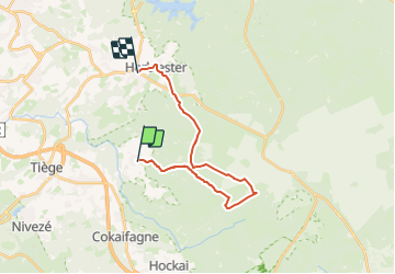
Tour Wandern von 17,1 km verfügbar auf Wallonien, Lüttich, Jalhay. Diese Tour wird von Chemin des Sources vorgeschlagen.
Beschreibung
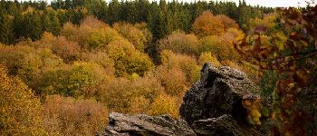
Gleich zu Beginn führt Sie ein Pfad in das Tal der Statte, wo Sie eine Welt der Legenden entdecken, wie den Bilisse-Felsen, den Steinbruch und den Nutons-Wasserfall.
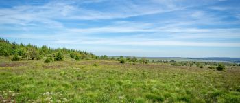
Das Hohe Venn muss man sich verdienen, und nach einer langen Steigung mündet der Chemin des Sources im Herzen des Naturschutzgebiets Hohes Venn Eifel.
Dieses außergewöhnliche Gebiet ist eine geschützte Zone, in der die Einhaltung der Regeln strengstens durchgesetzt werden muss.
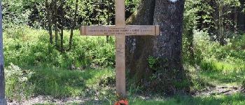
Das Kreuz der Verlobten auf der Vecquée ist der höchste Punkt (640 m) der 9 Etappen.
Nach einer angenehmen Fahrt durch Laubwälder werden Sie
erreichen Sie das Dorf Jalhay, das Land des Grünkohls.
Ort
Kommentare
Touren in der Umgebung
![Tour Wandern Jalhay - RB-LG-06 Raccourci 2 - Photo](https://media.geolcdn.com/t/375/260/ext.jpg?maxdim=2&url=https%3A%2F%2Fservices.sitytrail.com%2FGeolivesWS%2FDownloadMedia.ashx%3FTrailID%3D209412%26Media%3Dcbaa668b-becb-4b36-acb0-64f56a1c97b3.jpg)
![Wandern Wandern](https://static1.geolcdn.com/sitytour/trail-icons/101.png)
Wandern
![](/images/other/stat-length.png)
![](https://static1.geolcdn.com/siteimages/upload/files/16400158638029165_repeat_loop_refresh_sync_direction_icon.png)
![Tour Wandern Jalhay - RB-LG-06 - Au pied du plateau des Hautes Fagnes La balade des ruisseaux - Photo](https://media.geolcdn.com/t/375/260/ext.jpg?maxdim=2&url=https%3A%2F%2Fservices.sitytrail.com%2FGeolivesWS%2FDownloadMedia.ashx%3FTrailID%3D179564%26Media%3Dcbaa668b-becb-4b36-acb0-64f56a1c97b3.jpg)
![Wandern Wandern](https://static1.geolcdn.com/sitytour/trail-icons/101.png)
Wandern
![](/images/other/stat-length.png)
![](https://static1.geolcdn.com/siteimages/upload/files/16400158638029165_repeat_loop_refresh_sync_direction_icon.png)
![Tour Wandern Jalhay - Solwaster. Natura 2000, des sites qui valent le détour. Lg8 - Photo](https://media.geolcdn.com/t/375/260/ext.jpg?maxdim=2&url=https%3A%2F%2Fservices.sitytrail.com%2FGeolivesWS%2FDownloadMedia.ashx%3FTrailID%3D185776%26Media%3D07ec0791-d24b-4377-8f42-10c75b77cede.jpg)
![Wandern Wandern](https://static1.geolcdn.com/sitytour/trail-icons/101.png)
Wandern
![](/images/other/stat-length.png)
![](https://static1.geolcdn.com/siteimages/upload/files/16400158638029165_repeat_loop_refresh_sync_direction_icon.png)
![Tour Wandern Jalhay - Pont de Belleheid à Spa par le GRP 573 - Photo](https://media.geolcdn.com/t/375/260/ext.jpg?maxdim=2&url=https%3A%2F%2Fmedia.geolcdn.com%2Ff%2F0d2f83e8-ec88-4180-940e-6c42b7bb9bcf.jpg)
![Wandern Wandern](https://static1.geolcdn.com/sitytour/trail-icons/101.png)
Wandern
![](/images/other/stat-length.png)
![](https://static1.geolcdn.com/siteimages/upload/files/16400158638029165_repeat_loop_refresh_sync_direction_icon.png)
![Tour Wandern Theux - 20220901 - Jehanster 5.3 Km - Photo](https://media.geolcdn.com/t/375/260/ext.jpg?maxdim=2&url=https%3A%2F%2Fmedia.geolcdn.com%2Ff%2F21513cc5-be82-4323-813b-3b74ae756c6a.JPG)
![Wandern Wandern](https://static1.geolcdn.com/sitytour/trail-icons/101.png)
Wandern
![](/images/other/stat-length.png)
![](https://static1.geolcdn.com/siteimages/upload/files/16400158638029165_repeat_loop_refresh_sync_direction_icon.png)
![Tour Wandern Stablo - 20211213 - Hockay 5.4 Km - Photo](https://media.geolcdn.com/t/375/260/ext.jpg?maxdim=2&url=https%3A%2F%2Fmedia.geolcdn.com%2Ff%2F2af4f064-4123-4bf2-a6f0-d07b2843bf6f.JPG)
![Wandern Wandern](https://static1.geolcdn.com/sitytour/trail-icons/101.png)
Wandern
![](/images/other/stat-length.png)
![](https://static1.geolcdn.com/siteimages/upload/files/16400158638029165_repeat_loop_refresh_sync_direction_icon.png)
![Tour Wandern Jalhay - 2021-11-16_21h27m43_Cirkwi-Balade_à_Jalhay-Royompré_-_47 - Photo](https://media.geolcdn.com/t/375/260/ext.jpg?maxdim=2&url=https%3A%2F%2Fmedia.geolcdn.com%2Ff%2F94c262e0-20e7-4ae2-8b45-01b4c31da73b.jpg)
![Wandern Wandern](https://static1.geolcdn.com/sitytour/trail-icons/101.png)
Wandern
![](/images/other/stat-length.png)
![](https://static1.geolcdn.com/siteimages/upload/files/16400158638029165_repeat_loop_refresh_sync_direction_icon.png)
![Tour Wandern Jalhay - 2021-11-16_21h12m11_Cirkwi-Solwaster_Sawe_-_balade_56_B (1) - Photo](https://media.geolcdn.com/t/375/260/ext.jpg?maxdim=2&url=https%3A%2F%2Fmedia.geolcdn.com%2Ff%2F081cadfc-4766-4923-92bf-f568c48bec7d.jpg)
![Wandern Wandern](https://static1.geolcdn.com/sitytour/trail-icons/101.png)
Wandern
![](/images/other/stat-length.png)
![](https://static1.geolcdn.com/siteimages/upload/files/16400158638029165_repeat_loop_refresh_sync_direction_icon.png)
![Tour Laufen Jalhay - Jalhay-Trail-26km - Photo](https://media.geolcdn.com/t/375/260/ext.jpg?maxdim=2&url=https%3A%2F%2Fmedia.geolcdn.com%2Ff%2Fcfb58ec0-2055-46b2-8eac-aa502bd39e7d.jpg)
![Laufen Laufen](https://static1.geolcdn.com/sitytour/trail-icons/103.png)
Laufen
![](/images/other/stat-length.png)
![](https://static1.geolcdn.com/siteimages/upload/files/16400158638029165_repeat_loop_refresh_sync_direction_icon.png)
Splendide première partie le long de la Statte jusqu'au Hautes Fagnes, tandis que le retour est plus monotone avec de longues lignes droites.