![](/images/other/stat-length.png)
![Tour Wandern La Rochebeaucourt-et-Argentine - Argentine (24) découverte de ses trésors - Photo](https://media.geolcdn.com/t/1900/400/ext.pjpeg?maxdim=2&url=https%3A%2F%2Fservices.sitytrail.com%2FGeolivesWS%2FDownloadMedia.ashx%3FTrailID%3D314185%26Media%3Dfix__20140619112911.jpg)
Argentine (24) découverte de ses trésors
alainjoseph6
Benutzer
![Länge](/images/other/stat-length.png)
Länge
12,1 km
![Maximale Höhe](https://static1.geolcdn.com/siteimages/upload/files/1508320355ic_sort_altitude_max_24dp.png)
Maximale Höhe
182 m
![Positive Höhendifferenz](https://static1.geolcdn.com/siteimages/upload/files/1508320355ic_sort_den_pos_24dp.png)
Positive Höhendifferenz
152 m
![Km-Effort](/images/other/stat-length.png)
Km-Effort
14,2 km
![Min. Höhe](https://static1.geolcdn.com/siteimages/upload/files/1508320355ic_sort_altitude_min_24dp.png)
Min. Höhe
104 m
![Negative Höhendifferenz](https://static1.geolcdn.com/siteimages/upload/files/1508320355ic_sort_den_neg_24dp.png)
Negative Höhendifferenz
152 m
![Boucle](https://static1.geolcdn.com/siteimages/upload/files/16400158638029165_repeat_loop_refresh_sync_direction_icon.png)
Boucle
Ja
Erstellungsdatum :
2015-05-01 00:00:00.0
Letzte Änderung :
2015-05-01 00:00:00.0
![Wandern](https://static1.geolcdn.com/sitytour/trail-icons/101.png)
3h06
Schwierigkeit : Einfach
![Scannen Sie diesen QR-Code, um die Tour in der SityTrail-Anwendung zu öffnen](https://capi.geolives.com/qq0zvz2zws4bq2lad0pu/sitytour/trails/314185/qr.png?size=200)
Kostenlosegpshiking-Anwendung
Über SityTrail
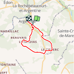
Tour Wandern von 12,1 km verfügbar auf Neu-Aquitanien, Dordogne, La Rochebeaucourt-et-Argentine. Diese Tour wird von alainjoseph6 vorgeschlagen.
Beschreibung
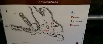
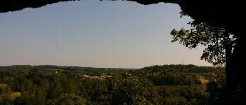
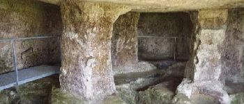
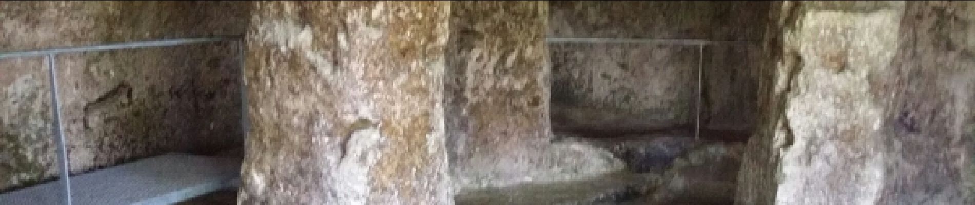
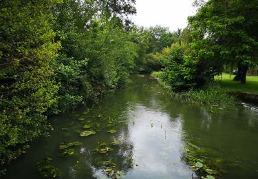
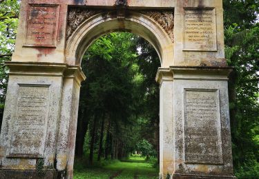
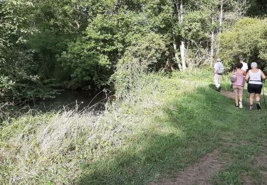
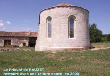
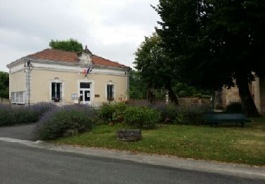
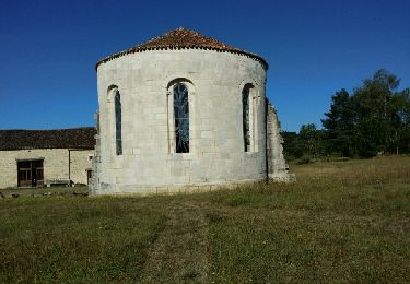
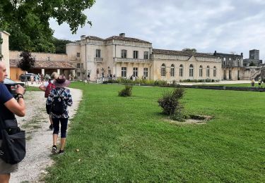
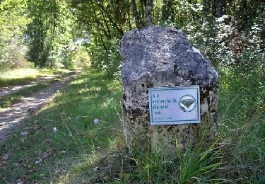
Superbe randonnée avec son circuit d'interprétation, ses petits villages typiques et la visite des cluzeaux et de son église d'Argentine avec une ancienne champignonnière.
POIs
Ort
Land:
France
Region :
Neu-Aquitanien
Abteilung/Provinz :
Dordogne
Kommune :
La Rochebeaucourt-et-Argentine
Standort:
Unknown
Gehen Sie:(Dec)
Gehen Sie:(UTM)
295473 ; 5038439 (31T) N.
Kommentare
Touren in der Umgebung
![Tour Wandern Combiers - La randonnée de Marchapack - Photo](https://media.geolcdn.com/t/375/260/ext.jpg?maxdim=2&url=https%3A%2F%2Fmedia.geolcdn.com%2Ff%2Fea8563e2-4ba2-481a-9ee5-82f48b60f3c1.jpg)
![Wandern Wandern](https://static1.geolcdn.com/sitytour/trail-icons/101.png)
La randonnée de Marchapack
Wandern
Medium
Combiers,
Neu-Aquitanien,
Charente,
France
![](/images/other/stat-length.png)
6 km | 6,9 km-effort
2h 40min
![](https://static1.geolcdn.com/siteimages/upload/files/16400158638029165_repeat_loop_refresh_sync_direction_icon.png)
Nein
![Tour Wandern La Rochebeaucourt-et-Argentine - Randonnée du 15 août 2022 Les gardiens du Patrimoine - Photo](https://media.geolcdn.com/t/375/260/ext.jpg?maxdim=2&url=https%3A%2F%2Fmedia.geolcdn.com%2Ff%2F621c97c7-1f63-4395-9b54-b39175723b89.jpg)
![Wandern Wandern](https://static1.geolcdn.com/sitytour/trail-icons/101.png)
Randonnée du 15 août 2022 Les gardiens du Patrimoine
Wandern
Medium
La Rochebeaucourt-et-Argentine,
Neu-Aquitanien,
Dordogne,
France
![](/images/other/stat-length.png)
10 km | 12,1 km-effort
2h 52min
![](https://static1.geolcdn.com/siteimages/upload/files/16400158638029165_repeat_loop_refresh_sync_direction_icon.png)
Ja
![Tour Wandern Combiers - Rando de Combiers à Larochebeaucourt par chez Maurice - Photo](https://media.geolcdn.com/t/375/260/ext.jpg?maxdim=2&url=https%3A%2F%2Fmedia.geolcdn.com%2Ff%2Fc6dc3ea3-705e-4acf-bc25-96c5897cc725.jpg)
![Wandern Wandern](https://static1.geolcdn.com/sitytour/trail-icons/101.png)
Rando de Combiers à Larochebeaucourt par chez Maurice
Wandern
Medium
Combiers,
Neu-Aquitanien,
Charente,
France
![](/images/other/stat-length.png)
10,2 km | 12,2 km-effort
3h 23min
![](https://static1.geolcdn.com/siteimages/upload/files/16400158638029165_repeat_loop_refresh_sync_direction_icon.png)
Ja
![Tour Wandern Combiers - Nouveau circuit de randonnée de COMBIERS - balisé jaune - Photo](https://media.geolcdn.com/t/375/260/ext.jpg?maxdim=2&url=https%3A%2F%2Fmedia.geolcdn.com%2Ff%2F378fcde2-24d9-47eb-a8d3-f0f1747efca6.jpg)
![Wandern Wandern](https://static1.geolcdn.com/sitytour/trail-icons/101.png)
Nouveau circuit de randonnée de COMBIERS - balisé jaune
Wandern
Einfach
Combiers,
Neu-Aquitanien,
Charente,
France
![](/images/other/stat-length.png)
11,2 km | 13,7 km-effort
2h 58min
![](https://static1.geolcdn.com/siteimages/upload/files/16400158638029165_repeat_loop_refresh_sync_direction_icon.png)
Ja
![Tour Wandern Combiers - De COMBIERS à la grange de l'ONF et retour par les Bernouillies - Photo](https://media.geolcdn.com/t/375/260/ext.jpg?maxdim=2&url=https%3A%2F%2Fservices.sitytrail.com%2FGeolivesWS%2FDownloadMedia.ashx%3FTrailID%3D796168%26Media%3Dfix__20170725090628.jpg)
![Wandern Wandern](https://static1.geolcdn.com/sitytour/trail-icons/101.png)
De COMBIERS à la grange de l'ONF et retour par les Bernouillies
Wandern
Einfach
Combiers,
Neu-Aquitanien,
Charente,
France
![](/images/other/stat-length.png)
12,5 km | 14,8 km-effort
3h 23min
![](https://static1.geolcdn.com/siteimages/upload/files/16400158638029165_repeat_loop_refresh_sync_direction_icon.png)
Ja
![Tour Wandern Combiers - Le circuit jaune de COMBIERS - Photo](https://media.geolcdn.com/t/375/260/ext.jpg?maxdim=2&url=https%3A%2F%2Fservices.sitytrail.com%2FGeolivesWS%2FDownloadMedia.ashx%3FTrailID%3D613175%26Media%3Dfix__20160812100856.jpg)
![Wandern Wandern](https://static1.geolcdn.com/sitytour/trail-icons/101.png)
Le circuit jaune de COMBIERS
Wandern
Einfach
Combiers,
Neu-Aquitanien,
Charente,
France
![](/images/other/stat-length.png)
11,2 km | 13,7 km-effort
2h 38min
![](https://static1.geolcdn.com/siteimages/upload/files/16400158638029165_repeat_loop_refresh_sync_direction_icon.png)
Ja
![Tour Wandern Combiers - rando combiers - Photo](https://media.geolcdn.com/t/375/260/ext.jpg?maxdim=2&url=https%3A%2F%2Fmedia.geolcdn.com%2Ff%2F6bfcb907-a727-4148-a353-c6cd8aafdd66.jpg)
![Wandern Wandern](https://static1.geolcdn.com/sitytour/trail-icons/101.png)
rando combiers
Wandern
Medium
Combiers,
Neu-Aquitanien,
Charente,
France
![](/images/other/stat-length.png)
19 km | 23 km-effort
3h 37min
![](https://static1.geolcdn.com/siteimages/upload/files/16400158638029165_repeat_loop_refresh_sync_direction_icon.png)
Ja
![Tour Wandern La Rochebeaucourt-et-Argentine - la randonnée de Larochebeaucourt et le parc delà vertue - Photo](https://media.geolcdn.com/t/375/260/ext.jpg?maxdim=2&url=https%3A%2F%2Fmedia.geolcdn.com%2Ff%2Ffad508f8-4338-4352-a82b-9c4914945e3b.jpg)
![Wandern Wandern](https://static1.geolcdn.com/sitytour/trail-icons/101.png)
la randonnée de Larochebeaucourt et le parc delà vertue
Wandern
Einfach
La Rochebeaucourt-et-Argentine,
Neu-Aquitanien,
Dordogne,
France
![](/images/other/stat-length.png)
5 km | 5,8 km-effort
2h 49min
![](https://static1.geolcdn.com/siteimages/upload/files/16400158638029165_repeat_loop_refresh_sync_direction_icon.png)
Ja
![Tour Wandern La Rochebeaucourt-et-Argentine - L'échappée belle - Photo](https://media.geolcdn.com/t/375/260/ext.jpg?maxdim=2&url=https%3A%2F%2Fmedia.geolcdn.com%2Ff%2F97111ea0-956f-4704-b966-34e6ac523e60.jpg)
![Wandern Wandern](https://static1.geolcdn.com/sitytour/trail-icons/101.png)
L'échappée belle
Wandern
Schwierig
La Rochebeaucourt-et-Argentine,
Neu-Aquitanien,
Dordogne,
France
![](/images/other/stat-length.png)
13,9 km | 16,7 km-effort
3h 48min
![](https://static1.geolcdn.com/siteimages/upload/files/16400158638029165_repeat_loop_refresh_sync_direction_icon.png)
Ja