Tour Wandern Gisors - gisors champêtre et historique  - Photo

gisors champêtre et historique

© OpenStreetMap contributors
Länge
Länge
12,1 km
Maximale Höhe
Maximale Höhe
84 m
Positive Höhendifferenz
106 m
Km-Effort
Km-Effort  
13,6 km
Min. Höhe
Min. Höhe
49 m
Negative Höhendifferenz
105 m
Boucle
Boucle
Ja
Erstellungsdatum :
2022-09-17 06:59:44.972
Letzte Änderung :
2022-09-17 10:36:35.573

(0 Nachricht)

Wandern
Wandern
2h13
Schwierigkeit : Schwierig

Scannen Sie diesen QR-Code, um die Tour in der SityTrail-Anwendung zu öffnen

Kostenlosegpshiking-Anwendung

Logo SityTrail SityTrail

IGN / Geografische Institute

SityTrail aus dem App Store herunterladen SityTrail von Google Play herunterladen

Logo SityTrail SityTrail World

Die Welt öffnet sich für Sie

SityTrail aus dem App Store herunterladen SityTrail von Google Play herunterladen SityTrail auf Huawei AppGallery herunterladen

Über SityTrail

Tour Wandern von 12,1 km verfügbar auf Normandie, Eure, Gisors. Diese Tour wird von serge.guerroult vorgeschlagen.

Beschreibung

laissez vous  guider sur un parcours en grande partie hors des sentiers battus mais aussi sur les GR12 5 et 225 sans oublier sur le passé médiéval et ....

Höhenprofil

Foto-Galerie

Ort

Land:
France
Region :
Normandie
Abteilung/Provinz :
Eure
Kommune :
Gisors
Standort:
Unknown
Gehen Sie:(UTM)
410720 ; 5459356 (31U) N.

Touren in der Umgebung

Tour Wandern Delincourt - Delincourt, Le Mesnil, Reilly, La vierge, Delincourt - Photo
Wandern
Marie-Claire-mcp

Wandern

Medium
(1)
Delincourt, Nordfrankreich, Oise, France
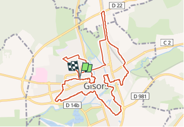
8,7 km | 10,4 km-effort
2h 16min
Ja
Tour Wandern Boury-en-Vexin - Boury en Vexin - Hérouval - Photo
Wandern
marcel.F

Wandern

Einfach
(3)
Boury-en-Vexin, Nordfrankreich, Oise, France
10,9 km | 12,9 km-effort
2h 49min
Ja
Tour Wandern Bézu-Saint-Éloi - Bézu Saint Eloi - Départ du parking route de Gisors (place St Eloi), puis Neaufles St martin - Photo
Wandern
Marie-Claire-mcp

Wandern

Medium
(1)
Bézu-Saint-Éloi, Normandie, Eure, France
10,3 km | 12 km-effort
2h 43min
Ja
Tour Nordic Walking Boury-en-Vexin - Marche Nordique 75 Boury en Vexin - Photo
Nordic Walking
marcel.F

Nordic Walking

Einfach
(1)
Boury-en-Vexin, Nordfrankreich, Oise, France
10,3 km | 12,6 km-effort
1h 30min
Ja
Tour Nordic Walking Courcelles-lès-Gisors - Marche Nordique 71 Courcelles les Gisors - Photo
Nordic Walking
marcel.F

Nordic Walking

Sehr leicht
(2)
Courcelles-lès-Gisors, Nordfrankreich, Oise, France
9,2 km | 10,9 km-effort
1h 26min
Ja
Tour Wandern Chambors - CHAMBORS - Lattainville-Delincourt-Reillly - Photo
Wandern
marcel.F

Wandern

Sehr leicht
(1)
Chambors, Nordfrankreich, Oise, France
12,3 km | 15,2 km-effort
2h 54min
Ja
Tour Nordic Walking Chambors - Marche Nordique 61 Chambors - Photo
Nordic Walking
marcel.F

Nordic Walking

Einfach
(1)
Chambors, Nordfrankreich, Oise, France
8,4 km | 10,3 km-effort
1h 30min
Ja
Tour Wandern Trie-Château - Trie Château - La vallée de l'Aunette - Photo
Wandern
marcel.F

Wandern

Schwierig
(1)
Trie-Château, Nordfrankreich, Oise, France
11,8 km | 13,7 km-effort
3h 0min
Ja
Tour Wandern Chambors - Chambors - le dolmen 12 - Photo
Wandern
marcel.F

Wandern

Einfach
(1)
Chambors, Nordfrankreich, Oise, France
12,4 km | 16 km-effort
3h 31min
Ja


Schließen
Meine Abonnements