![](/images/other/stat-length.png)
![Tour Wandern Arès - Arès départ port ostréicole Aresdecpuverte - Photo](https://media.geolcdn.com/t/1900/400/ext.pjpeg?maxdim=2&url=https%3A%2F%2Fstatic1.geolcdn.com%2Fsiteimages%2Fupload%2Ffiles%2F1553511878bg_sport_marche.png)
Arès départ port ostréicole Aresdecpuverte
20LTh
Benutzer
![Länge](/images/other/stat-length.png)
Länge
14,4 km
![Maximale Höhe](https://static1.geolcdn.com/siteimages/upload/files/1508320355ic_sort_altitude_max_24dp.png)
Maximale Höhe
16 m
![Positive Höhendifferenz](https://static1.geolcdn.com/siteimages/upload/files/1508320355ic_sort_den_pos_24dp.png)
Positive Höhendifferenz
94 m
![Km-Effort](/images/other/stat-length.png)
Km-Effort
15,7 km
![Min. Höhe](https://static1.geolcdn.com/siteimages/upload/files/1508320355ic_sort_altitude_min_24dp.png)
Min. Höhe
-2 m
![Negative Höhendifferenz](https://static1.geolcdn.com/siteimages/upload/files/1508320355ic_sort_den_neg_24dp.png)
Negative Höhendifferenz
93 m
![Boucle](https://static1.geolcdn.com/siteimages/upload/files/16400158638029165_repeat_loop_refresh_sync_direction_icon.png)
Boucle
Ja
Erstellungsdatum :
2022-10-09 07:40:20.0
Letzte Änderung :
2022-10-09 16:26:21.323
![Wandern](https://static1.geolcdn.com/sitytour/trail-icons/101.png)
7h38
Schwierigkeit : Sehr leicht
![Scannen Sie diesen QR-Code, um die Tour in der SityTrail-Anwendung zu öffnen](https://capi.geolives.com/qq0zvz2zws4bq2lad0pu/sitytour/trails/3418574/qr.png?size=200)
Kostenlosegpshiking-Anwendung
Über SityTrail
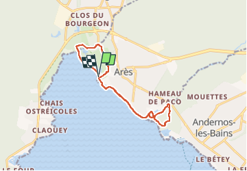
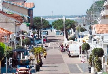
Tour Wandern von 14,4 km verfügbar auf Neu-Aquitanien, Gironde, Arès. Diese Tour wird von 20LTh vorgeschlagen.
Beschreibung
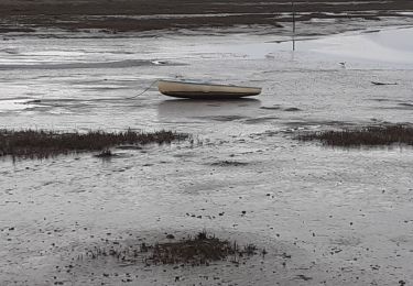
Découverte Ares bord de bassin et sous bois, sans difficulté.temps du parcours avec certains arrêts inclus.
Ort
Land:
France
Region :
Neu-Aquitanien
Abteilung/Provinz :
Gironde
Kommune :
Arès
Standort:
Unknown
Gehen Sie:(Dec)
Gehen Sie:(UTM)
646391 ; 4958708 (30T) N.
Kommentare
Touren in der Umgebung
![Tour Hybrid-Bike Arès - Vélo Arès Cap Feret - Photo](https://media.geolcdn.com/t/375/260/ext.jpg?maxdim=2&url=https%3A%2F%2Fmedia.geolcdn.com%2Ff%2F873f7bb6-c81f-4ee5-ac74-bed0238ffe60.jpg)
![Hybrid-Bike Hybrid-Bike](https://static1.geolcdn.com/sitytour/trail-icons/203.png)
Vélo Arès Cap Feret
Hybrid-Bike
Medium
Arès,
Neu-Aquitanien,
Gironde,
France
![](/images/other/stat-length.png)
56 km | 62 km-effort
4h 48min
![](https://static1.geolcdn.com/siteimages/upload/files/16400158638029165_repeat_loop_refresh_sync_direction_icon.png)
Nein
![Tour Wandern Andernos-les-Bains - Les quinconces - Photo](https://media.geolcdn.com/t/375/260/ext.jpg?maxdim=2&url=https%3A%2F%2Fstatic1.geolcdn.com%2Fsiteimages%2Fupload%2Ffiles%2F1553511878bg_sport_marche.png)
![Wandern Wandern](https://static1.geolcdn.com/sitytour/trail-icons/101.png)
Les quinconces
Wandern
Sehr leicht
(1)
Andernos-les-Bains,
Neu-Aquitanien,
Gironde,
France
![](/images/other/stat-length.png)
7 km | 7,6 km-effort
2h 55min
![](https://static1.geolcdn.com/siteimages/upload/files/16400158638029165_repeat_loop_refresh_sync_direction_icon.png)
Ja
![Tour Elektrofahrrad Lège-Cap-Ferret - Sortie Lacanau - Photo](https://media.geolcdn.com/t/375/260/ext.jpg?maxdim=2&url=https%3A%2F%2Fmedia.geolcdn.com%2Ff%2F7ed4c728-c115-445a-a435-85386e44651b.jpg)
![Elektrofahrrad Elektrofahrrad](https://static1.geolcdn.com/sitytour/trail-icons/205.png)
Sortie Lacanau
Elektrofahrrad
Sehr leicht
Lège-Cap-Ferret,
Neu-Aquitanien,
Gironde,
France
![](/images/other/stat-length.png)
73 km | 80 km-effort
3h 24min
![](https://static1.geolcdn.com/siteimages/upload/files/16400158638029165_repeat_loop_refresh_sync_direction_icon.png)
Ja
![Tour Elektrofahrrad Lège-Cap-Ferret - Le cap feret - Photo](https://media.geolcdn.com/t/375/260/ext.jpg?maxdim=2&url=https%3A%2F%2Fmedia.geolcdn.com%2Ff%2F8217cc80-b40e-44d9-800c-e425422724f5.jpg)
![Elektrofahrrad Elektrofahrrad](https://static1.geolcdn.com/sitytour/trail-icons/205.png)
Le cap feret
Elektrofahrrad
Medium
Lège-Cap-Ferret,
Neu-Aquitanien,
Gironde,
France
![](/images/other/stat-length.png)
88 km | 96 km-effort
4h 28min
![](https://static1.geolcdn.com/siteimages/upload/files/16400158638029165_repeat_loop_refresh_sync_direction_icon.png)
Ja
![Tour Wandern Arès - les prés salés la teste de buch - Photo](https://media.geolcdn.com/t/375/260/ext.jpg?maxdim=2&url=https%3A%2F%2Fmedia.geolcdn.com%2Ff%2Ffc01b79f-f710-46c8-99b3-a8ce921b7899.jpg)
![Wandern Wandern](https://static1.geolcdn.com/sitytour/trail-icons/101.png)
les prés salés la teste de buch
Wandern
Sehr leicht
(1)
Arès,
Neu-Aquitanien,
Gironde,
France
![](/images/other/stat-length.png)
7,1 km | 7,5 km-effort
2h 37min
![](https://static1.geolcdn.com/siteimages/upload/files/16400158638029165_repeat_loop_refresh_sync_direction_icon.png)
Ja
![Tour Fahrrad Arès - de Ares à Sanguinet - Photo](https://media.geolcdn.com/t/375/260/ext.jpg?maxdim=2&url=https%3A%2F%2Fservices.sitytrail.com%2FGeolivesWS%2FDownloadMedia.ashx%3FTrailID%3D450845%26Media%3D2cca1fec-375e-4780-a004-31cdd349b60d.jpg)
![Fahrrad Fahrrad](https://static1.geolcdn.com/sitytour/trail-icons/200.png)
de Ares à Sanguinet
Fahrrad
Einfach
Arès,
Neu-Aquitanien,
Gironde,
France
![](/images/other/stat-length.png)
82 km | 90 km-effort
5h 8min
![](https://static1.geolcdn.com/siteimages/upload/files/16400158638029165_repeat_loop_refresh_sync_direction_icon.png)
Nein
![Tour Wandern Andernos-les-Bains - les près salés - Photo](https://media.geolcdn.com/t/375/260/ext.jpg?maxdim=2&url=https%3A%2F%2Fservices.sitytrail.com%2FGeolivesWS%2FDownloadMedia.ashx%3FTrailID%3D249261%26Media%3Dfix__20140212144514.jpg)
![Wandern Wandern](https://static1.geolcdn.com/sitytour/trail-icons/101.png)
les près salés
Wandern
Medium
(1)
Andernos-les-Bains,
Neu-Aquitanien,
Gironde,
France
![](/images/other/stat-length.png)
19,3 km | 21 km-effort
4h 28min
![](https://static1.geolcdn.com/siteimages/upload/files/16400158638029165_repeat_loop_refresh_sync_direction_icon.png)
Ja
![Tour Wandern Andernos-les-Bains - Arés - Photo](https://media.geolcdn.com/t/375/260/ext.jpg?maxdim=2&url=https%3A%2F%2Fstatic1.geolcdn.com%2Fsiteimages%2Fupload%2Ffiles%2F1553511878bg_sport_marche.png)
![Wandern Wandern](https://static1.geolcdn.com/sitytour/trail-icons/101.png)
Arés
Wandern
Einfach
(1)
Andernos-les-Bains,
Neu-Aquitanien,
Gironde,
France
![](/images/other/stat-length.png)
11,8 km | 12,8 km-effort
2h 0min
![](https://static1.geolcdn.com/siteimages/upload/files/16400158638029165_repeat_loop_refresh_sync_direction_icon.png)
Ja
![Tour Nordic Walking Lège-Cap-Ferret - Lège Cap Ferret - le canal - Photo](https://media.geolcdn.com/t/375/260/ext.jpg?maxdim=2&url=https%3A%2F%2Fmedia.geolcdn.com%2Ff%2F2243a043-a5b0-4b32-b467-fadfd20f096a.jpg)
![Nordic Walking Nordic Walking](https://static1.geolcdn.com/sitytour/trail-icons/102.png)
Lège Cap Ferret - le canal
Nordic Walking
Sehr leicht
Lège-Cap-Ferret,
Neu-Aquitanien,
Gironde,
France
![](/images/other/stat-length.png)
15,4 km | 16,4 km-effort
Unbekannt
![](https://static1.geolcdn.com/siteimages/upload/files/16400158638029165_repeat_loop_refresh_sync_direction_icon.png)
Ja