![](/images/other/stat-length.png)
![Tour Mountainbike Saint-Antoine-du-Rocher - St.Antoine-Nouzilly-St.Antoine-38,7 Km-Le 23 Novembre 2014-Auteur tintin37 - Photo](https://media.geolcdn.com/t/1900/400/ext.pjpeg?maxdim=2&url=https%3A%2F%2Fstatic1.geolcdn.com%2Fsiteimages%2Fupload%2Ffiles%2F1524743154velo.jpg)
St.Antoine-Nouzilly-St.Antoine-38,7 Km-Le 23 Novembre 2014-Auteur tintin37
Martinjeanclaude
Benutzer
![Länge](/images/other/stat-length.png)
Länge
39 km
![Maximale Höhe](https://static1.geolcdn.com/siteimages/upload/files/1508320355ic_sort_altitude_max_24dp.png)
Maximale Höhe
146 m
![Positive Höhendifferenz](https://static1.geolcdn.com/siteimages/upload/files/1508320355ic_sort_den_pos_24dp.png)
Positive Höhendifferenz
421 m
![Km-Effort](/images/other/stat-length.png)
Km-Effort
44 km
![Min. Höhe](https://static1.geolcdn.com/siteimages/upload/files/1508320355ic_sort_altitude_min_24dp.png)
Min. Höhe
77 m
![Negative Höhendifferenz](https://static1.geolcdn.com/siteimages/upload/files/1508320355ic_sort_den_neg_24dp.png)
Negative Höhendifferenz
422 m
![Boucle](https://static1.geolcdn.com/siteimages/upload/files/16400158638029165_repeat_loop_refresh_sync_direction_icon.png)
Boucle
Ja
Erstellungsdatum :
2014-12-10 00:00:00.0
Letzte Änderung :
2014-12-10 00:00:00.0
![Mountainbike](https://static1.geolcdn.com/sitytour/trail-icons/202.png)
2h56
Schwierigkeit : Medium
![Scannen Sie diesen QR-Code, um die Tour in der SityTrail-Anwendung zu öffnen](https://capi.geolives.com/qq0zvz2zws4bq2lad0pu/sitytour/trails/365443/qr.png?size=200)
Kostenlosegpshiking-Anwendung
Über SityTrail
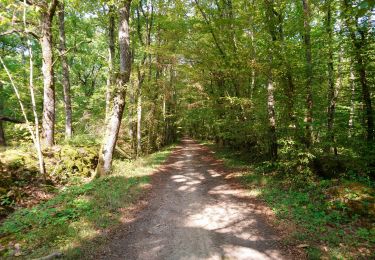
Tour Mountainbike von 39 km verfügbar auf Zentrum-Loiretal, Indre-et-Loire, Saint-Antoine-du-Rocher. Diese Tour wird von Martinjeanclaude vorgeschlagen.
Beschreibung
Parti de La Garenne , Cerelles ,Allé dans bois en direction de Nouzilly , Nouzilly , Beaumont la Ronce , Direction Neuillé , Lencloitre , A28 , Pont gibiers ,La Garenne
Ort
Land:
France
Region :
Zentrum-Loiretal
Abteilung/Provinz :
Indre-et-Loire
Kommune :
Saint-Antoine-du-Rocher
Standort:
Unknown
Gehen Sie:(Dec)
Gehen Sie:(UTM)
320886 ; 5262750 (31T) N.
Kommentare
Touren in der Umgebung
![Tour Wandern Cerelles - Cerelles - Photo](https://media.geolcdn.com/t/375/260/ext.jpg?maxdim=2&url=https%3A%2F%2Fservices.sitytrail.com%2FGeolivesWS%2FDownloadMedia.ashx%3FTrailID%3D231250%26Media%3Dfix__20131106141542.jpg)
![Wandern Wandern](https://static1.geolcdn.com/sitytour/trail-icons/101.png)
Cerelles
Wandern
Einfach
(1)
Cerelles,
Zentrum-Loiretal,
Indre-et-Loire,
France
![](/images/other/stat-length.png)
10,5 km | 12,5 km-effort
2h 42min
![](https://static1.geolcdn.com/siteimages/upload/files/16400158638029165_repeat_loop_refresh_sync_direction_icon.png)
Ja
![Tour Wandern Rouziers-de-Touraine - bois bourdeil beaumont variante - Photo](https://media.geolcdn.com/t/375/260/ext.jpg?maxdim=2&url=https%3A%2F%2Fstatic1.geolcdn.com%2Fsiteimages%2Fupload%2Ffiles%2F1553511878bg_sport_marche.png)
![Wandern Wandern](https://static1.geolcdn.com/sitytour/trail-icons/101.png)
bois bourdeil beaumont variante
Wandern
Einfach
(1)
Rouziers-de-Touraine,
Zentrum-Loiretal,
Indre-et-Loire,
France
![](/images/other/stat-length.png)
12,6 km | 14,6 km-effort
2h 38min
![](https://static1.geolcdn.com/siteimages/upload/files/16400158638029165_repeat_loop_refresh_sync_direction_icon.png)
Ja
![Tour Wandern Semblançay - Semblançay - Circuit les Etangs - Photo](https://media.geolcdn.com/t/375/260/ext.jpg?maxdim=2&url=https%3A%2F%2Fmedia.geolcdn.com%2Ff%2Ff8a0420d-6268-4ce6-9de6-9ad2d70c7497.jpg)
![Wandern Wandern](https://static1.geolcdn.com/sitytour/trail-icons/101.png)
Semblançay - Circuit les Etangs
Wandern
Medium
Semblançay,
Zentrum-Loiretal,
Indre-et-Loire,
France
![](/images/other/stat-length.png)
19,7 km | 22 km-effort
4h 55min
![](https://static1.geolcdn.com/siteimages/upload/files/16400158638029165_repeat_loop_refresh_sync_direction_icon.png)
Ja
![Tour Wandern Rouziers-de-Touraine - Rouziers-de-Touraine - Circuit 3 - 21km 175m 5h00 (35mn) - 2023 05 21 - Photo](https://media.geolcdn.com/t/375/260/ext.jpg?maxdim=2&url=https%3A%2F%2Fmedia.geolcdn.com%2Ff%2F2c3469a1-6005-4652-bab3-634d6cf350c3.jpg)
![Wandern Wandern](https://static1.geolcdn.com/sitytour/trail-icons/101.png)
Rouziers-de-Touraine - Circuit 3 - 21km 175m 5h00 (35mn) - 2023 05 21
Wandern
Einfach
Rouziers-de-Touraine,
Zentrum-Loiretal,
Indre-et-Loire,
France
![](/images/other/stat-length.png)
21 km | 23 km-effort
5h 0min
![](https://static1.geolcdn.com/siteimages/upload/files/16400158638029165_repeat_loop_refresh_sync_direction_icon.png)
Ja
![Tour Wandern Saint-Antoine-du-Rocher - Saint-Antoine-du-Rocher - Rouziers-de-Touraine - 21.4km 165m 4h55 - 2022 04 03 - Photo](https://media.geolcdn.com/t/375/260/ext.jpg?maxdim=2&url=https%3A%2F%2Fmedia.geolcdn.com%2Ff%2F8b36e295-8247-4873-9751-f344e6172f47.jpg)
![Wandern Wandern](https://static1.geolcdn.com/sitytour/trail-icons/101.png)
Saint-Antoine-du-Rocher - Rouziers-de-Touraine - 21.4km 165m 4h55 - 2022 04 03
Wandern
Einfach
Saint-Antoine-du-Rocher,
Zentrum-Loiretal,
Indre-et-Loire,
France
![](/images/other/stat-length.png)
21 km | 24 km-effort
4h 55min
![](https://static1.geolcdn.com/siteimages/upload/files/16400158638029165_repeat_loop_refresh_sync_direction_icon.png)
Ja
![Tour Wandern Charentilly - Charentilly - PR la Choisillette avec variante - 9km 100m 1h50 - 2020 11 28 - Photo](https://media.geolcdn.com/t/375/260/ext.jpg?maxdim=2&url=https%3A%2F%2Fmedia.geolcdn.com%2Ff%2Fc1b744c0-bc06-4fe5-a4fc-24f9728adfe5.jpg)
![Wandern Wandern](https://static1.geolcdn.com/sitytour/trail-icons/101.png)
Charentilly - PR la Choisillette avec variante - 9km 100m 1h50 - 2020 11 28
Wandern
Einfach
Charentilly,
Zentrum-Loiretal,
Indre-et-Loire,
France
![](/images/other/stat-length.png)
9 km | 10,4 km-effort
1h 50min
![](https://static1.geolcdn.com/siteimages/upload/files/16400158638029165_repeat_loop_refresh_sync_direction_icon.png)
Ja
![Tour Wandern Cerelles - Cérelles - Circuits 2 puis 1 - 18.9km 255m 4h05 - 2020 09 11 - Photo](https://media.geolcdn.com/t/375/260/ext.jpg?maxdim=2&url=https%3A%2F%2Fmedia.geolcdn.com%2Ff%2F2967519f-5900-49cf-b0ee-522e62c44bc9.jpg)
![Wandern Wandern](https://static1.geolcdn.com/sitytour/trail-icons/101.png)
Cérelles - Circuits 2 puis 1 - 18.9km 255m 4h05 - 2020 09 11
Wandern
Medium
Cerelles,
Zentrum-Loiretal,
Indre-et-Loire,
France
![](/images/other/stat-length.png)
18,9 km | 22 km-effort
4h 5min
![](https://static1.geolcdn.com/siteimages/upload/files/16400158638029165_repeat_loop_refresh_sync_direction_icon.png)
Ja
![Tour Wandern Charentilly - Charentilly - Circuit 2 avec variante - 14.8km 135m 3h05 - 2020 08 15 - Photo](https://media.geolcdn.com/t/375/260/ext.jpg?maxdim=2&url=https%3A%2F%2Fmedia.geolcdn.com%2Ff%2F3d2c51a1-3af7-44d8-bc0c-6a33566d6f6e.jpg)
![Wandern Wandern](https://static1.geolcdn.com/sitytour/trail-icons/101.png)
Charentilly - Circuit 2 avec variante - 14.8km 135m 3h05 - 2020 08 15
Wandern
Einfach
Charentilly,
Zentrum-Loiretal,
Indre-et-Loire,
France
![](/images/other/stat-length.png)
14,8 km | 16,6 km-effort
3h 5min
![](https://static1.geolcdn.com/siteimages/upload/files/16400158638029165_repeat_loop_refresh_sync_direction_icon.png)
Ja
![Tour Wandern Mettray - Mettray - Dolmen - 12.9km 160m 2h40 - 2020 07 26 - Photo](https://media.geolcdn.com/t/375/260/ext.jpg?maxdim=2&url=https%3A%2F%2Fmedia.geolcdn.com%2Ff%2F7eb82ac0-48df-4237-a483-c208fe4e7abd.jpg)
![Wandern Wandern](https://static1.geolcdn.com/sitytour/trail-icons/101.png)
Mettray - Dolmen - 12.9km 160m 2h40 - 2020 07 26
Wandern
Einfach
Mettray,
Zentrum-Loiretal,
Indre-et-Loire,
France
![](/images/other/stat-length.png)
12,9 km | 15 km-effort
2h 40min
![](https://static1.geolcdn.com/siteimages/upload/files/16400158638029165_repeat_loop_refresh_sync_direction_icon.png)
Ja
est-ce du vtt?