![](/images/other/stat-length.png)
![Tour Andere Aktivitäten Le Castellet - St Anne du castellet . la font de Marc. Le chemin medieval - Photo](https://media.geolcdn.com/t/1900/400/ext.pjpeg?maxdim=2&url=https%3A%2F%2Fservices.sitytrail.com%2FGeolivesWS%2FDownloadMedia.ashx%3FTrailID%3D367080%26Media%3Dfix__20141202161336.jpg)
St Anne du castellet . la font de Marc. Le chemin medieval
marchev
Benutzer
![Länge](/images/other/stat-length.png)
Länge
13,3 km
![Maximale Höhe](https://static1.geolcdn.com/siteimages/upload/files/1508320355ic_sort_altitude_max_24dp.png)
Maximale Höhe
429 m
![Positive Höhendifferenz](https://static1.geolcdn.com/siteimages/upload/files/1508320355ic_sort_den_pos_24dp.png)
Positive Höhendifferenz
380 m
![Km-Effort](/images/other/stat-length.png)
Km-Effort
18,4 km
![Min. Höhe](https://static1.geolcdn.com/siteimages/upload/files/1508320355ic_sort_altitude_min_24dp.png)
Min. Höhe
155 m
![Negative Höhendifferenz](https://static1.geolcdn.com/siteimages/upload/files/1508320355ic_sort_den_neg_24dp.png)
Negative Höhendifferenz
383 m
![Boucle](https://static1.geolcdn.com/siteimages/upload/files/16400158638029165_repeat_loop_refresh_sync_direction_icon.png)
Boucle
Ja
Erstellungsdatum :
2014-12-10 00:00:00.0
Letzte Änderung :
2014-12-10 00:00:00.0
![Andere Aktivitäten](https://static1.geolcdn.com/sitytour/trail-icons/900.png)
5h17
Schwierigkeit : Medium
![Scannen Sie diesen QR-Code, um die Tour in der SityTrail-Anwendung zu öffnen](https://capi.geolives.com/qq0zvz2zws4bq2lad0pu/sitytour/trails/367080/qr.png?size=200)
Kostenlosegpshiking-Anwendung
Über SityTrail
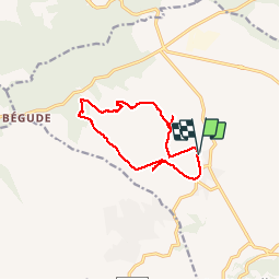
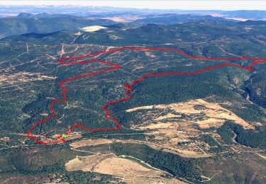
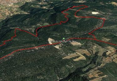
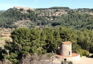
Tour Andere Aktivitäten von 13,3 km verfügbar auf Provence-Alpes-Côte d'Azur, Var, Le Castellet. Diese Tour wird von marchev vorgeschlagen.
Beschreibung
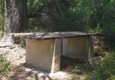
jolie randonnée qui nous fait découvrir four à cade, chaux, poix. Beau chemin caladé, ancien chemin de Toulon à Aix.
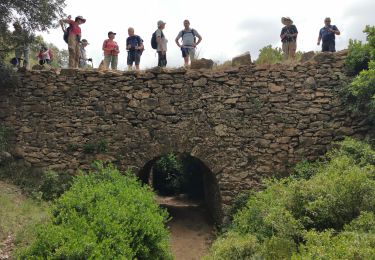
La vrai Roche Redonne et son abri de berger. Au retour vue mer et pont romain du Cannet
Ort
Land:
France
Region :
Provence-Alpes-Côte d'Azur
Abteilung/Provinz :
Var
Kommune :
Le Castellet
Standort:
Unknown
Gehen Sie:(Dec)
Gehen Sie:(UTM)
724290 ; 4790344 (31T) N.
Kommentare
Touren in der Umgebung
![Tour Wandern Le Beausset - Trace_Quatre_Freres - Photo](https://media.geolcdn.com/t/375/260/ext.jpg?maxdim=2&url=https%3A%2F%2Fmedia.geolcdn.com%2Ff%2Fa076bf67-1e95-4bda-8264-007e64206af1.jpg)
![Wandern Wandern](https://static1.geolcdn.com/sitytour/trail-icons/101.png)
Trace_Quatre_Freres
Wandern
Sehr schwierig
(1)
Le Beausset,
Provence-Alpes-Côte d'Azur,
Var,
France
![](/images/other/stat-length.png)
14,8 km | 19,6 km-effort
4h 26min
![](https://static1.geolcdn.com/siteimages/upload/files/16400158638029165_repeat_loop_refresh_sync_direction_icon.png)
Ja
![Tour Wandern Le Castellet - SityTrail - 2361987 - begude - Photo](https://media.geolcdn.com/t/375/260/ext.jpg?maxdim=2&url=https%3A%2F%2Fmedia.geolcdn.com%2Ff%2Fdbe90af6-979b-4145-807f-db327fb40379.jpg)
![Wandern Wandern](https://static1.geolcdn.com/sitytour/trail-icons/101.png)
SityTrail - 2361987 - begude
Wandern
Medium
(1)
Le Castellet,
Provence-Alpes-Côte d'Azur,
Var,
France
![](/images/other/stat-length.png)
11,5 km | 15,1 km-effort
4h 0min
![](https://static1.geolcdn.com/siteimages/upload/files/16400158638029165_repeat_loop_refresh_sync_direction_icon.png)
Ja
![Tour Wandern Le Beausset - Tête du Cade par abime de Maramouyé - Photo](https://media.geolcdn.com/t/375/260/ext.jpg?maxdim=2&url=https%3A%2F%2Fservices.sitytrail.com%2FGeolivesWS%2FDownloadMedia.ashx%3FTrailID%3D1038187%26Media%3Dfix__20180911112303.jpg)
![Wandern Wandern](https://static1.geolcdn.com/sitytour/trail-icons/101.png)
Tête du Cade par abime de Maramouyé
Wandern
Sehr leicht
(1)
Le Beausset,
Provence-Alpes-Côte d'Azur,
Var,
France
![](/images/other/stat-length.png)
12,4 km | 16,1 km-effort
3h 36min
![](https://static1.geolcdn.com/siteimages/upload/files/16400158638029165_repeat_loop_refresh_sync_direction_icon.png)
Ja
![Tour Nordic Walking La Cadière-d'Azur - 20220329_La Cadière d'Azur - Photo](https://media.geolcdn.com/t/375/260/ext.jpg?maxdim=2&url=https%3A%2F%2Fstatic1.geolcdn.com%2Fsiteimages%2Fupload%2Ffiles%2F1545311037marcheuse_200dpi.jpg)
![Nordic Walking Nordic Walking](https://static1.geolcdn.com/sitytour/trail-icons/102.png)
20220329_La Cadière d'Azur
Nordic Walking
Sehr leicht
(1)
La Cadière-d'Azur,
Provence-Alpes-Côte d'Azur,
Var,
France
![](/images/other/stat-length.png)
6,8 km | 8,6 km-effort
1h 30min
![](https://static1.geolcdn.com/siteimages/upload/files/16400158638029165_repeat_loop_refresh_sync_direction_icon.png)
Ja
![Tour Wandern Cuges-les-Pins - cuges barres de castillon OK coral - Photo](https://media.geolcdn.com/t/375/260/ext.jpg?maxdim=2&url=https%3A%2F%2Fmedia.geolcdn.com%2Ff%2F886762c3-484d-410a-9360-386115a5dec4.jpg)
![Wandern Wandern](https://static1.geolcdn.com/sitytour/trail-icons/101.png)
cuges barres de castillon OK coral
Wandern
Medium
(1)
Cuges-les-Pins,
Provence-Alpes-Côte d'Azur,
Bouches-du-Rhône,
France
![](/images/other/stat-length.png)
10,9 km | 14,9 km-effort
5h 54min
![](https://static1.geolcdn.com/siteimages/upload/files/16400158638029165_repeat_loop_refresh_sync_direction_icon.png)
Ja
![Tour Wandern Signes - grotte du mounoi signes - Photo](https://media.geolcdn.com/t/375/260/ext.jpg?maxdim=2&url=https%3A%2F%2Fservices.sitytrail.com%2FGeolivesWS%2FDownloadMedia.ashx%3FTrailID%3D266184%26Media%3Dfix__20140413111146.jpg)
![Wandern Wandern](https://static1.geolcdn.com/sitytour/trail-icons/101.png)
grotte du mounoi signes
Wandern
Medium
(1)
Signes,
Provence-Alpes-Côte d'Azur,
Var,
France
![](/images/other/stat-length.png)
17 km | 21 km-effort
4h 45min
![](https://static1.geolcdn.com/siteimages/upload/files/16400158638029165_repeat_loop_refresh_sync_direction_icon.png)
Ja
![Tour Wandern Le Castellet - Roche Redonne depuis Ste Anne du Castelet - Photo](https://media.geolcdn.com/t/375/260/ext.jpg?maxdim=2&url=https%3A%2F%2Fmedia.geolcdn.com%2Ff%2Fcebdae65-72ef-4e31-931e-0efa1e0463c0.jpg)
![Wandern Wandern](https://static1.geolcdn.com/sitytour/trail-icons/101.png)
Roche Redonne depuis Ste Anne du Castelet
Wandern
Schwierig
Le Castellet,
Provence-Alpes-Côte d'Azur,
Var,
France
![](/images/other/stat-length.png)
11 km | 15,7 km-effort
3h 34min
![](https://static1.geolcdn.com/siteimages/upload/files/16400158638029165_repeat_loop_refresh_sync_direction_icon.png)
Ja
![Tour Wandern La Cadière-d'Azur - la Cadière d'Azur 01-03-2024 - Photo](https://media.geolcdn.com/t/375/260/ext.jpg?maxdim=2&url=https%3A%2F%2Fmedia.geolcdn.com%2Ff%2Fe01b6a60-4b3b-4fb0-93c7-011648b90b15.jpg)
![Wandern Wandern](https://static1.geolcdn.com/sitytour/trail-icons/101.png)
la Cadière d'Azur 01-03-2024
Wandern
Einfach
La Cadière-d'Azur,
Provence-Alpes-Côte d'Azur,
Var,
France
![](/images/other/stat-length.png)
6,3 km | 8,3 km-effort
2h 26min
![](https://static1.geolcdn.com/siteimages/upload/files/16400158638029165_repeat_loop_refresh_sync_direction_icon.png)
Ja