![](/images/other/stat-length.png)
![Tour Wandern Roquebrune-sur-Argens - au paradis des campeurs - Photo](https://media.geolcdn.com/t/1900/400/ext.pjpeg?maxdim=2&url=https%3A%2F%2Fstatic1.geolcdn.com%2Fsiteimages%2Fupload%2Ffiles%2F1553511878bg_sport_marche.png)
au paradis des campeurs
jiam6852
Benutzer
![Länge](/images/other/stat-length.png)
Länge
5,9 km
![Maximale Höhe](https://static1.geolcdn.com/siteimages/upload/files/1508320355ic_sort_altitude_max_24dp.png)
Maximale Höhe
216 m
![Positive Höhendifferenz](https://static1.geolcdn.com/siteimages/upload/files/1508320355ic_sort_den_pos_24dp.png)
Positive Höhendifferenz
220 m
![Km-Effort](/images/other/stat-length.png)
Km-Effort
8,9 km
![Min. Höhe](https://static1.geolcdn.com/siteimages/upload/files/1508320355ic_sort_altitude_min_24dp.png)
Min. Höhe
4 m
![Negative Höhendifferenz](https://static1.geolcdn.com/siteimages/upload/files/1508320355ic_sort_den_neg_24dp.png)
Negative Höhendifferenz
222 m
![Boucle](https://static1.geolcdn.com/siteimages/upload/files/16400158638029165_repeat_loop_refresh_sync_direction_icon.png)
Boucle
Ja
Erstellungsdatum :
2024-02-14 11:52:08.422
Letzte Änderung :
2024-02-15 06:15:54.212
![Wandern](https://static1.geolcdn.com/sitytour/trail-icons/101.png)
2h06
Schwierigkeit : Medium
![Scannen Sie diesen QR-Code, um die Tour in der SityTrail-Anwendung zu öffnen](https://capi.geolives.com/qq0zvz2zws4bq2lad0pu/sitytour/trails/3950407/qr.png?size=200)
Kostenlosegpshiking-Anwendung
Über SityTrail
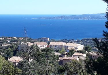
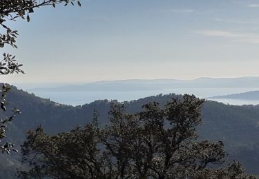
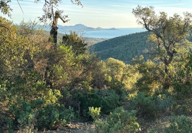
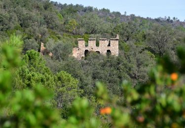
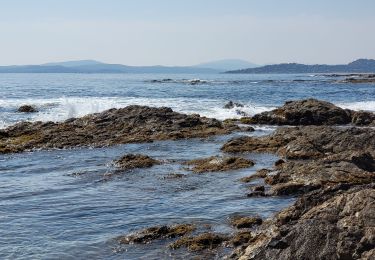
Tour Wandern von 5,9 km verfügbar auf Provence-Alpes-Côte d'Azur, Var, Roquebrune-sur-Argens. Diese Tour wird von jiam6852 vorgeschlagen.
Beschreibung
nombreux points de vue dans cette ballade en forêt. Le point de vue 360° sur la carte n est plus accessible.
Ort
Land:
France
Region :
Provence-Alpes-Côte d'Azur
Abteilung/Provinz :
Var
Kommune :
Roquebrune-sur-Argens
Standort:
Unknown
Gehen Sie:(Dec)
Gehen Sie:(UTM)
314512 ; 4804081 (32T) N.
Kommentare
Touren in der Umgebung
![Tour Wandern Fréjus - Etang de Villepey - Photo](https://media.geolcdn.com/t/375/260/ext.jpg?maxdim=2&url=https%3A%2F%2Fservices.sitytrail.com%2FGeolivesWS%2FDownloadMedia.ashx%3FTrailID%3D734327%26Media%3Dfix__20170416160746.jpg)
![Wandern Wandern](https://static1.geolcdn.com/sitytour/trail-icons/101.png)
Etang de Villepey
Wandern
Sehr leicht
(2)
Fréjus,
Provence-Alpes-Côte d'Azur,
Var,
France
![](/images/other/stat-length.png)
6,5 km | 7 km-effort
3h 4min
![](https://static1.geolcdn.com/siteimages/upload/files/16400158638029165_repeat_loop_refresh_sync_direction_icon.png)
Ja
![Tour Wandern Roquebrune-sur-Argens - 200526 Les Issambres - Photo](https://media.geolcdn.com/t/375/260/ext.jpg?maxdim=2&url=https%3A%2F%2Fstatic1.geolcdn.com%2Fsiteimages%2Fupload%2Ffiles%2F1553511878bg_sport_marche.png)
![Wandern Wandern](https://static1.geolcdn.com/sitytour/trail-icons/101.png)
200526 Les Issambres
Wandern
Medium
(1)
Roquebrune-sur-Argens,
Provence-Alpes-Côte d'Azur,
Var,
France
![](/images/other/stat-length.png)
8,3 km | 12,2 km-effort
2h 33min
![](https://static1.geolcdn.com/siteimages/upload/files/16400158638029165_repeat_loop_refresh_sync_direction_icon.png)
Ja
![Tour Wandern Roquebrune-sur-Argens - la Gaillarde - Photo](https://media.geolcdn.com/t/375/260/ext.jpg?maxdim=2&url=https%3A%2F%2Fmedia.geolcdn.com%2Ff%2F125c2b5e-47e1-41cd-9dff-65f7af0300f6.jpg)
![Wandern Wandern](https://static1.geolcdn.com/sitytour/trail-icons/101.png)
la Gaillarde
Wandern
Einfach
Roquebrune-sur-Argens,
Provence-Alpes-Côte d'Azur,
Var,
France
![](/images/other/stat-length.png)
6,5 km | 10,1 km-effort
1h 59min
![](https://static1.geolcdn.com/siteimages/upload/files/16400158638029165_repeat_loop_refresh_sync_direction_icon.png)
Ja
![Tour Wandern Roquebrune-sur-Argens - Gaillarde - Photo](https://media.geolcdn.com/t/375/260/ext.jpg?maxdim=2&url=https%3A%2F%2Fstatic1.geolcdn.com%2Fsiteimages%2Fupload%2Ffiles%2F1553511878bg_sport_marche.png)
![Wandern Wandern](https://static1.geolcdn.com/sitytour/trail-icons/101.png)
Gaillarde
Wandern
Einfach
(2)
Roquebrune-sur-Argens,
Provence-Alpes-Côte d'Azur,
Var,
France
![](/images/other/stat-length.png)
8,3 km | 12,7 km-effort
2h 40min
![](https://static1.geolcdn.com/siteimages/upload/files/16400158638029165_repeat_loop_refresh_sync_direction_icon.png)
Ja
![Tour Wandern Fréjus - VVA 2109 Etangs de Villepey - Photo](https://media.geolcdn.com/t/375/260/ext.jpg?maxdim=2&url=https%3A%2F%2Fstatic1.geolcdn.com%2Fsiteimages%2Fupload%2Ffiles%2F1553511878bg_sport_marche.png)
![Wandern Wandern](https://static1.geolcdn.com/sitytour/trail-icons/101.png)
VVA 2109 Etangs de Villepey
Wandern
Einfach
(1)
Fréjus,
Provence-Alpes-Côte d'Azur,
Var,
France
![](/images/other/stat-length.png)
17 km | 19,6 km-effort
4h 13min
![](https://static1.geolcdn.com/siteimages/upload/files/16400158638029165_repeat_loop_refresh_sync_direction_icon.png)
Ja
![Tour Wandern Fréjus - petites maures - Photo](https://media.geolcdn.com/t/375/260/ext.jpg?maxdim=2&url=https%3A%2F%2Fmedia.geolcdn.com%2Ff%2F4bf41242-1129-430c-9ca5-ba54544e6d76.jpg)
![Wandern Wandern](https://static1.geolcdn.com/sitytour/trail-icons/101.png)
petites maures
Wandern
Schwierig
Fréjus,
Provence-Alpes-Côte d'Azur,
Var,
France
![](/images/other/stat-length.png)
12,9 km | 17,5 km-effort
4h 47min
![](https://static1.geolcdn.com/siteimages/upload/files/16400158638029165_repeat_loop_refresh_sync_direction_icon.png)
Nein
![Tour Wandern Roquebrune-sur-Argens - Col du Bougnon : la Garonnette - Photo](https://media.geolcdn.com/t/375/260/ext.jpg?maxdim=2&url=https%3A%2F%2Fmedia.geolcdn.com%2Ff%2F0d614b7a-381f-42c2-94c2-191c569a24dd.jpg)
![Wandern Wandern](https://static1.geolcdn.com/sitytour/trail-icons/101.png)
Col du Bougnon : la Garonnette
Wandern
Medium
Roquebrune-sur-Argens,
Provence-Alpes-Côte d'Azur,
Var,
France
![](/images/other/stat-length.png)
17,6 km | 28 km-effort
6h 16min
![](https://static1.geolcdn.com/siteimages/upload/files/16400158638029165_repeat_loop_refresh_sync_direction_icon.png)
Ja
![Tour Wandern Roquebrune-sur-Argens - La Bergerie - Piste des Clapiers - Bastide Abbe - Photo](https://media.geolcdn.com/t/375/260/ext.jpg?maxdim=2&url=https%3A%2F%2Fmedia.geolcdn.com%2Ff%2Fab05948e-72b7-4e9f-b009-18d08b62cd58.JPG)
![Wandern Wandern](https://static1.geolcdn.com/sitytour/trail-icons/101.png)
La Bergerie - Piste des Clapiers - Bastide Abbe
Wandern
Einfach
Roquebrune-sur-Argens,
Provence-Alpes-Côte d'Azur,
Var,
France
![](/images/other/stat-length.png)
10,2 km | 13,4 km-effort
2h 39min
![](https://static1.geolcdn.com/siteimages/upload/files/16400158638029165_repeat_loop_refresh_sync_direction_icon.png)
Ja
![Tour Wandern Roquebrune-sur-Argens - LES ISSAMBRES - BOUCLE PAR SAN PEIRE - Photo](https://media.geolcdn.com/t/375/260/ext.jpg?maxdim=2&url=https%3A%2F%2Fmedia.geolcdn.com%2Ff%2F5f778908-4959-4901-8cb5-a585b8ad3339.jpg)
![Wandern Wandern](https://static1.geolcdn.com/sitytour/trail-icons/101.png)
LES ISSAMBRES - BOUCLE PAR SAN PEIRE
Wandern
Einfach
Roquebrune-sur-Argens,
Provence-Alpes-Côte d'Azur,
Var,
France
![](/images/other/stat-length.png)
8,8 km | 11,5 km-effort
5h 6min
![](https://static1.geolcdn.com/siteimages/upload/files/16400158638029165_repeat_loop_refresh_sync_direction_icon.png)
Ja