Tour Wandern Orsières - Grand et Petit Col Ferret - Photo

Grand et Petit Col Ferret

 verbier
verbier

Benutzer

© OpenStreetMap contributors
Länge
Länge
14,4 km
Maximale Höhe
Maximale Höhe
2563 m
Positive Höhendifferenz
1039 m
Km-Effort
Km-Effort  
28 km
Min. Höhe
Min. Höhe
1619 m
Negative Höhendifferenz
1039 m
Boucle
Boucle
Ja
Erstellungsdatum :
2014-12-10 00:00:00.0
Letzte Änderung :
2014-12-10 00:00:00.0

(0 Nachricht)

Wandern
Wandern
4h45
Schwierigkeit : Unbekannt

Scannen Sie diesen QR-Code, um die Tour in der SityTrail-Anwendung zu öffnen

Kostenlosegpshiking-Anwendung

Logo SityTrail SityTrail

IGN / Geografische Institute

SityTrail aus dem App Store herunterladen SityTrail von Google Play herunterladen

Logo SityTrail SityTrail World

Die Welt öffnet sich für Sie

SityTrail aus dem App Store herunterladen SityTrail von Google Play herunterladen SityTrail auf Huawei AppGallery herunterladen

Über SityTrail

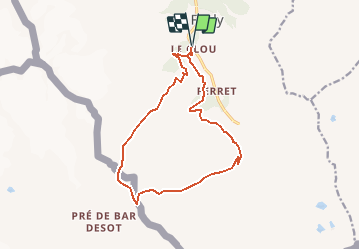
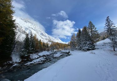
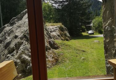
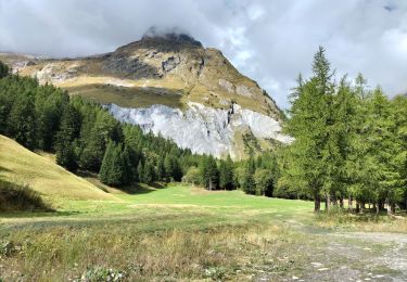
Tour Wandern von 14,4 km verfügbar auf Wallis, Entremont, Orsières. Diese Tour wird von verbier vorgeschlagen.

Beschreibung

Start from La Fouly. Follow the road as far as the little village “Les Granges”, then turn right to the gîte “La Léchère”. From there, go on the path to the Petit Col Ferret. Go through the ridge on the Italian side to the Grand Col Ferret. Go back down taking the path of the Tour du Mont-Blanc, which is going through “La Peule”, then go on the path to get to “La Léchère”. You will arrive at your departure point.

Höhenprofil

POIs

POI Orsières - Grand Col Ferret - Photo
verbier
ORSIÈRES 
POI Orsières - La Peule - Photo
verbier
ORSIÈRES 
POI Courmayeur - Petit Col Ferret - Photo
verbier
COURMAYEUR 
POI Orsières - La Léchère - Photo
verbier
ORSIÈRES 
POI Orsières - Les Granges - Photo
verbier
ORSIÈRES 

Ort

Land:
Switzerland
Region :
Wallis
Abteilung/Provinz :
Entremont
Kommune :
Orsières
Standort:
Unknown
Gehen Sie:(Dec)
Gehen Sie:(UTM)
352432 ; 5087663 (32T) N.

Touren in der Umgebung

Tour Zu Fuß Orsières - Trail Verbier St-Bernard - Traversée - Photo
Zu Fuß
PRO

Zu Fuß

Sehr schwierig
Orsières, Wallis, Entremont, Switzerland
37 km | 70 km-effort
15h 47min
Nein
Tour Zu Fuß Orsières - Sentier des Bergers - Photo
Zu Fuß
PRO

Zu Fuß

Einfach
Orsières, Wallis, Entremont, Switzerland
4,8 km | 9,2 km-effort
2h 5min
Nein
Tour Zu Fuß Courmayeur - Itinerario 23 Rifugio Dalmazzi - Photo
Zu Fuß
PRO

Zu Fuß

Einfach
Courmayeur, Aostatal, Unbekannt, Italy
4,1 km | 6,6 km-effort
1h 29min
Nein
Tour Wandern Courmayeur - TMB J4 Ref.ELENA - COURMAYEUR - Photo
Wandern
GerardBouche

Wandern

Medium
Courmayeur, Aostatal, Unbekannt, Italy
13,5 km | 22 km-effort
4h 18min
Nein
Tour Wandern Orsières - La Fouly, Randonée hivernale, Sentier de l''Amône  - Photo
Wandern
verbier

Wandern

Sehr leicht
(1)
Orsières, Wallis, Entremont, Switzerland
1,9 km | 2,7 km-effort
50min
Ja
Tour Wandern Orsières - ferret La Foully - Photo
Wandern
michauxpaul

Wandern

Medium
Orsières, Wallis, Entremont, Switzerland
4,6 km | 6,1 km-effort
2h 20min
Nein
Tour Wandern Orsières - fully  - Photo
Wandern
suzanne.bron

Wandern

Einfach
Orsières, Wallis, Entremont, Switzerland
3,8 km | 4,9 km-effort
1h 19min
Nein
Tour Wandern Courmayeur - TMB6 AN - Photo
Wandern
reneperrin

Wandern

Einfach
Courmayeur, Aostatal, Unbekannt, Italy
12,6 km | 21 km-effort
4h 5min
Nein
Tour Wandern Orsières - TMB J3 La FOULY - Ref. ELENA - Photo
Wandern
GerardBouche

Wandern

Schwierig
Orsières, Wallis, Entremont, Switzerland
10,3 km | 23 km-effort
4h 46min
Nein


Schließen
Meine Abonnements