![](/images/other/stat-length.png)
![Tour Wandern Saint-Jacut-de-la-Mer - Saint Jacut-de-Mer - Photo](https://media.geolcdn.com/t/1900/400/ext.pjpeg?maxdim=2&url=https%3A%2F%2Fstatic1.geolcdn.com%2Fsiteimages%2Fupload%2Ffiles%2F1553511878bg_sport_marche.png)
Saint Jacut-de-Mer
vitius
Benutzer
![Länge](/images/other/stat-length.png)
Länge
18,1 km
![Maximale Höhe](https://static1.geolcdn.com/siteimages/upload/files/1508320355ic_sort_altitude_max_24dp.png)
Maximale Höhe
46 m
![Positive Höhendifferenz](https://static1.geolcdn.com/siteimages/upload/files/1508320355ic_sort_den_pos_24dp.png)
Positive Höhendifferenz
205 m
![Km-Effort](/images/other/stat-length.png)
Km-Effort
21 km
![Min. Höhe](https://static1.geolcdn.com/siteimages/upload/files/1508320355ic_sort_altitude_min_24dp.png)
Min. Höhe
-3 m
![Negative Höhendifferenz](https://static1.geolcdn.com/siteimages/upload/files/1508320355ic_sort_den_neg_24dp.png)
Negative Höhendifferenz
205 m
![Boucle](https://static1.geolcdn.com/siteimages/upload/files/16400158638029165_repeat_loop_refresh_sync_direction_icon.png)
Boucle
Ja
Erstellungsdatum :
2019-05-07 16:39:30.484
Letzte Änderung :
2019-05-07 16:39:31.314
![Wandern](https://static1.geolcdn.com/sitytour/trail-icons/101.png)
5h30
Schwierigkeit : Schwierig
![Scannen Sie diesen QR-Code, um die Tour in der SityTrail-Anwendung zu öffnen](https://capi.geolives.com/qq0zvz2zws4bq2lad0pu/sitytour/trails/573012/qr.png?size=200)
Kostenlosegpshiking-Anwendung
Über SityTrail
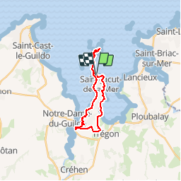
Tour Wandern von 18,1 km verfügbar auf Bretagne, Côtes-d'Armor, Saint-Jacut-de-la-Mer. Diese Tour wird von vitius vorgeschlagen.
Beschreibung
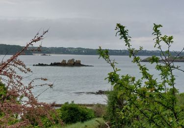
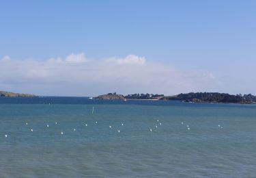
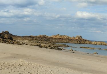
Randonnée : le tour de la presqu'ile de Saint Jacut-de-la-Mer avec une traversée de la baie pour visiter les iles des Hébidens
Ort
Land:
France
Region :
Bretagne
Abteilung/Provinz :
Côtes-d'Armor
Kommune :
Saint-Jacut-de-la-Mer
Standort:
Unknown
Gehen Sie:(Dec)
Gehen Sie:(UTM)
559572 ; 5384050 (30U) N.
Kommentare
Touren in der Umgebung
![Tour Zu Fuß Lancieux - Chemin des Poissoniers - Photo](https://media.geolcdn.com/t/375/260/ext.jpg?maxdim=2&url=https%3A%2F%2Fmedia.geolcdn.com%2Ff%2F5766fb3e-1c2e-4f5d-a7d3-e9d598898327.jpeg)
![Zu Fuß Zu Fuß](https://static1.geolcdn.com/sitytour/trail-icons/100.png)
Chemin des Poissoniers
Zu Fuß
Einfach
Lancieux,
Bretagne,
Côtes-d'Armor,
France
![](/images/other/stat-length.png)
7,3 km | 8,3 km-effort
1h 52min
![](https://static1.geolcdn.com/siteimages/upload/files/16400158638029165_repeat_loop_refresh_sync_direction_icon.png)
Ja
![Tour Zu Fuß Lancieux - Autour de Lancieux - Photo](https://media.geolcdn.com/t/375/260/ext.jpg?maxdim=2&url=https%3A%2F%2Fmedia.geolcdn.com%2Ff%2F18d11f25-421d-4ea3-b01f-45ea981b4922.jpeg)
![Zu Fuß Zu Fuß](https://static1.geolcdn.com/sitytour/trail-icons/100.png)
Autour de Lancieux
Zu Fuß
Einfach
Lancieux,
Bretagne,
Côtes-d'Armor,
France
![](/images/other/stat-length.png)
10,9 km | 12,2 km-effort
2h 45min
![](https://static1.geolcdn.com/siteimages/upload/files/16400158638029165_repeat_loop_refresh_sync_direction_icon.png)
Ja
![Tour Wandern Lancieux - lancieux - Photo](https://media.geolcdn.com/t/375/260/ext.jpg?maxdim=2&url=https%3A%2F%2Fstatic1.geolcdn.com%2Fsiteimages%2Fupload%2Ffiles%2F1553511878bg_sport_marche.png)
![Wandern Wandern](https://static1.geolcdn.com/sitytour/trail-icons/101.png)
lancieux
Wandern
Einfach
(2)
Lancieux,
Bretagne,
Côtes-d'Armor,
France
![](/images/other/stat-length.png)
11,7 km | 13 km-effort
2h 47min
![](https://static1.geolcdn.com/siteimages/upload/files/16400158638029165_repeat_loop_refresh_sync_direction_icon.png)
Ja
![Tour Wandern Saint-Briac-sur-Mer - Saint-Briac(boucle) - Photo](https://media.geolcdn.com/t/375/260/ext.jpg?maxdim=2&url=https%3A%2F%2Fstatic1.geolcdn.com%2Fsiteimages%2Fupload%2Ffiles%2F1553511878bg_sport_marche.png)
![Wandern Wandern](https://static1.geolcdn.com/sitytour/trail-icons/101.png)
Saint-Briac(boucle)
Wandern
Einfach
(1)
Saint-Briac-sur-Mer,
Bretagne,
Ille-et-Vilaine,
France
![](/images/other/stat-length.png)
11,9 km | 13,8 km-effort
3h 3min
![](https://static1.geolcdn.com/siteimages/upload/files/16400158638029165_repeat_loop_refresh_sync_direction_icon.png)
Ja
![Tour Wandern Saint-Cast-le-Guildo - GR_34_BD_10_St-Cast-Le-Guildo_Frehel_20230507 - Photo](https://media.geolcdn.com/t/375/260/ext.jpg?maxdim=2&url=https%3A%2F%2Fmedia.geolcdn.com%2Ff%2F068f3db5-6257-4ba4-9962-6c14136b62c6.jpg)
![Wandern Wandern](https://static1.geolcdn.com/sitytour/trail-icons/101.png)
GR_34_BD_10_St-Cast-Le-Guildo_Frehel_20230507
Wandern
Einfach
Saint-Cast-le-Guildo,
Bretagne,
Côtes-d'Armor,
France
![](/images/other/stat-length.png)
18 km | 22 km-effort
5h 11min
![](https://static1.geolcdn.com/siteimages/upload/files/16400158638029165_repeat_loop_refresh_sync_direction_icon.png)
Nein
![Tour Wandern Saint-Jacut-de-la-Mer - GR_34_BC_09_St-Jacut-De-La-Mer_St-Cast-Le-Guildo_20230506 - Photo](https://media.geolcdn.com/t/375/260/ext.jpg?maxdim=2&url=https%3A%2F%2Fmedia.geolcdn.com%2Ff%2Fa6421446-397c-40f2-8ef8-6251eb55e355.jpg)
![Wandern Wandern](https://static1.geolcdn.com/sitytour/trail-icons/101.png)
GR_34_BC_09_St-Jacut-De-La-Mer_St-Cast-Le-Guildo_20230506
Wandern
Einfach
Saint-Jacut-de-la-Mer,
Bretagne,
Côtes-d'Armor,
France
![](/images/other/stat-length.png)
18,4 km | 23 km-effort
5h 9min
![](https://static1.geolcdn.com/siteimages/upload/files/16400158638029165_repeat_loop_refresh_sync_direction_icon.png)
Nein
![Tour Wandern Lancieux - GR_34_BB_08_Lancieux_St-Jacut-De-La-Mer_20230412 - Photo](https://media.geolcdn.com/t/375/260/ext.jpg?maxdim=2&url=https%3A%2F%2Fmedia.geolcdn.com%2Ff%2F86a0b3e1-a1c8-42ed-96fe-98d26efbe101.jpg)
![Wandern Wandern](https://static1.geolcdn.com/sitytour/trail-icons/101.png)
GR_34_BB_08_Lancieux_St-Jacut-De-La-Mer_20230412
Wandern
Schwierig
Lancieux,
Bretagne,
Côtes-d'Armor,
France
![](/images/other/stat-length.png)
15,9 km | 17,8 km-effort
4h 2min
![](https://static1.geolcdn.com/siteimages/upload/files/16400158638029165_repeat_loop_refresh_sync_direction_icon.png)
Nein
![Tour Wandern Saint-Cast-le-Guildo - les 4 Vaux. Pen Guen - Photo](https://media.geolcdn.com/t/375/260/ext.jpg?maxdim=2&url=https%3A%2F%2Fmedia.geolcdn.com%2Ff%2F9c051867-9892-4ee3-a39c-78d231c8b844.jpg)
![Wandern Wandern](https://static1.geolcdn.com/sitytour/trail-icons/101.png)
les 4 Vaux. Pen Guen
Wandern
Medium
Saint-Cast-le-Guildo,
Bretagne,
Côtes-d'Armor,
France
![](/images/other/stat-length.png)
6 km | 7,9 km-effort
1h 51min
![](https://static1.geolcdn.com/siteimages/upload/files/16400158638029165_repeat_loop_refresh_sync_direction_icon.png)
Ja
![Tour Wandern Saint-Jacut-de-la-Mer - îles des hebihens - Photo](https://media.geolcdn.com/t/375/260/ext.jpg?maxdim=2&url=https%3A%2F%2Fmedia.geolcdn.com%2Ff%2F62e1a056-179a-4626-b808-38cbde70ac24.jpg)
![Wandern Wandern](https://static1.geolcdn.com/sitytour/trail-icons/101.png)
îles des hebihens
Wandern
Einfach
Saint-Jacut-de-la-Mer,
Bretagne,
Côtes-d'Armor,
France
![](/images/other/stat-length.png)
7,5 km | 8,7 km-effort
2h 5min
![](https://static1.geolcdn.com/siteimages/upload/files/16400158638029165_repeat_loop_refresh_sync_direction_icon.png)
Ja