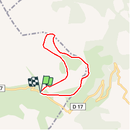
![](/images/other/stat-length.png)
Autour du col la Saume
Gouze13
Benutzer
![Länge](/images/other/stat-length.png)
Länge
5,7 km
![Maximale Höhe](https://static1.geolcdn.com/siteimages/upload/files/1508320355ic_sort_altitude_max_24dp.png)
Maximale Höhe
1989 m
![Positive Höhendifferenz](https://static1.geolcdn.com/siteimages/upload/files/1508320355ic_sort_den_pos_24dp.png)
Positive Höhendifferenz
556 m
![Km-Effort](/images/other/stat-length.png)
Km-Effort
13,1 km
![Min. Höhe](https://static1.geolcdn.com/siteimages/upload/files/1508320355ic_sort_altitude_min_24dp.png)
Min. Höhe
1588 m
![Negative Höhendifferenz](https://static1.geolcdn.com/siteimages/upload/files/1508320355ic_sort_den_neg_24dp.png)
Negative Höhendifferenz
546 m
![Boucle](https://static1.geolcdn.com/siteimages/upload/files/16400158638029165_repeat_loop_refresh_sync_direction_icon.png)
Boucle
Ja
Erstellungsdatum :
2018-04-17 11:04:51.669
Letzte Änderung :
2018-09-24 17:11:30.346
![Wandern](https://static1.geolcdn.com/sitytour/trail-icons/101.png)
2h00
Schwierigkeit : Sehr schwierig
![Scannen Sie diesen QR-Code, um die Tour in der SityTrail-Anwendung zu öffnen](https://capi.geolives.com/qq0zvz2zws4bq2lad0pu/sitytour/trails/848437/qr.png?size=200)
Kostenlosegpshiking-Anwendung
Über SityTrail
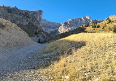
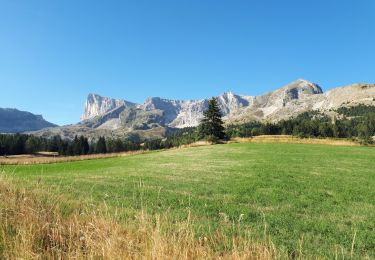
Tour Wandern von 5,7 km verfügbar auf Provence-Alpes-Côte d'Azur, Hochalpen, Le Dévoluy. Diese Tour wird von Gouze13 vorgeschlagen.
Beschreibung
Essentiellement hors sentier. Descente sud du sommet 2007m trés raide et expo sur 30m. On peut toutefois retourner au col en quelques minutes et poursuivre la rando en passant en dessous.
Ort
Land:
France
Region :
Provence-Alpes-Côte d'Azur
Abteilung/Provinz :
Hochalpen
Kommune :
Le Dévoluy
Standort:
Unknown
Gehen Sie:(Dec)
Gehen Sie:(UTM)
735870 ; 4953526 (31T) N.
Kommentare
Touren in der Umgebung
![Tour Wandern Le Dévoluy - R29 La crete des Beaumes - Photo](https://media.geolcdn.com/t/375/260/ext.jpg?maxdim=2&url=https%3A%2F%2Fservices.sitytrail.com%2FGeolivesWS%2FDownloadMedia.ashx%3FTrailID%3D890888%26Media%3Da26bb0d1-74cd-455a-a17c-3db0bb6ab810.jpg)
![Wandern Wandern](https://static1.geolcdn.com/sitytour/trail-icons/101.png)
R29 La crete des Beaumes
Wandern
Medium
(2)
Le Dévoluy,
Provence-Alpes-Côte d'Azur,
Hochalpen,
France
![](/images/other/stat-length.png)
9 km | 16 km-effort
3h 17min
![](https://static1.geolcdn.com/siteimages/upload/files/16400158638029165_repeat_loop_refresh_sync_direction_icon.png)
Ja
![Tour Wandern Le Dévoluy - R28 Le Col de Rabou - Photo](https://media.geolcdn.com/t/375/260/ext.jpg?maxdim=2&url=https%3A%2F%2Fservices.sitytrail.com%2FGeolivesWS%2FDownloadMedia.ashx%3FTrailID%3D890887%26Media%3D6a4babdc-bd98-40ff-bea6-0d96c76c9150.jpg)
![Wandern Wandern](https://static1.geolcdn.com/sitytour/trail-icons/101.png)
R28 Le Col de Rabou
Wandern
Medium
(1)
Le Dévoluy,
Provence-Alpes-Côte d'Azur,
Hochalpen,
France
![](/images/other/stat-length.png)
10,6 km | 17,9 km-effort
3h 52min
![](https://static1.geolcdn.com/siteimages/upload/files/16400158638029165_repeat_loop_refresh_sync_direction_icon.png)
Ja
![Tour Wandern Le Dévoluy - R27 Les gorges du Rif - Photo](https://media.geolcdn.com/t/375/260/ext.jpg?maxdim=2&url=https%3A%2F%2Fservices.sitytrail.com%2FGeolivesWS%2FDownloadMedia.ashx%3FTrailID%3D890885%26Media%3Dcec0c897-28b2-484d-9e1f-9a7c0ab1ea05.jpg)
![Wandern Wandern](https://static1.geolcdn.com/sitytour/trail-icons/101.png)
R27 Les gorges du Rif
Wandern
Einfach
(1)
Le Dévoluy,
Provence-Alpes-Côte d'Azur,
Hochalpen,
France
![](/images/other/stat-length.png)
7,5 km | 11,5 km-effort
2h 27min
![](https://static1.geolcdn.com/siteimages/upload/files/16400158638029165_repeat_loop_refresh_sync_direction_icon.png)
Ja
![Tour Wandern Le Dévoluy - Tour du Dévoluy - Superdévoluy à Lachaup - Photo](https://media.geolcdn.com/t/375/260/ext.jpg?maxdim=2&url=https%3A%2F%2Fservices.sitytrail.com%2FGeolivesWS%2FDownloadMedia.ashx%3FTrailID%3D105029%26Media%3D8589_5.jpg)
![Wandern Wandern](https://static1.geolcdn.com/sitytour/trail-icons/101.png)
Tour du Dévoluy - Superdévoluy à Lachaup
Wandern
Medium
(1)
Le Dévoluy,
Provence-Alpes-Côte d'Azur,
Hochalpen,
France
![](/images/other/stat-length.png)
8,3 km | 12,5 km-effort
3h 0min
![](https://static1.geolcdn.com/siteimages/upload/files/16400158638029165_repeat_loop_refresh_sync_direction_icon.png)
Nein
![Tour Mountainbike Le Dévoluy - VTT31 - Col de Rabou - Photo](https://media.geolcdn.com/t/375/260/ext.jpg?maxdim=2&url=https%3A%2F%2Fservices.sitytrail.com%2FGeolivesWS%2FDownloadMedia.ashx%3FTrailID%3D894052%26Media%3D3694f463-e0fc-4686-accd-a63c5223fb6f.jpg)
![Mountainbike Mountainbike](https://static1.geolcdn.com/sitytour/trail-icons/202.png)
VTT31 - Col de Rabou
Mountainbike
Medium
Le Dévoluy,
Provence-Alpes-Côte d'Azur,
Hochalpen,
France
![](/images/other/stat-length.png)
19,7 km | 31 km-effort
1h 55min
![](https://static1.geolcdn.com/siteimages/upload/files/16400158638029165_repeat_loop_refresh_sync_direction_icon.png)
Ja
![Tour Wandern Le Dévoluy - R26 Le tour de la crête d'âne - Photo](https://media.geolcdn.com/t/375/260/ext.jpg?maxdim=2&url=https%3A%2F%2Fservices.sitytrail.com%2FGeolivesWS%2FDownloadMedia.ashx%3FTrailID%3D890884%26Media%3D7256db8e-d5b8-4869-8dcf-eba2814c941a.jpg)
![Wandern Wandern](https://static1.geolcdn.com/sitytour/trail-icons/101.png)
R26 Le tour de la crête d'âne
Wandern
Medium
Le Dévoluy,
Provence-Alpes-Côte d'Azur,
Hochalpen,
France
![](/images/other/stat-length.png)
10,5 km | 19,7 km-effort
3h 58min
![](https://static1.geolcdn.com/siteimages/upload/files/16400158638029165_repeat_loop_refresh_sync_direction_icon.png)
Ja
![Tour Wandern Le Dévoluy - crête des baumes - Photo](https://media.geolcdn.com/t/375/260/ext.jpg?maxdim=2&url=https%3A%2F%2Fservices.sitytrail.com%2FGeolivesWS%2FDownloadMedia.ashx%3FTrailID%3D338245%26Media%3Dfix__20140823125332.jpg)
![Wandern Wandern](https://static1.geolcdn.com/sitytour/trail-icons/101.png)
crête des baumes
Wandern
Einfach
(1)
Le Dévoluy,
Provence-Alpes-Côte d'Azur,
Hochalpen,
France
![](/images/other/stat-length.png)
9,4 km | 14,1 km-effort
3h 11min
![](https://static1.geolcdn.com/siteimages/upload/files/16400158638029165_repeat_loop_refresh_sync_direction_icon.png)
Ja
![Tour Wandern Le Dévoluy - pic de Bure - Photo](https://media.geolcdn.com/t/375/260/ext.jpg?maxdim=2&url=https%3A%2F%2Fmedia.geolcdn.com%2Ff%2Fc8160a3c-74c6-414c-b5b3-4a2c087d16e0.jpg)
![Wandern Wandern](https://static1.geolcdn.com/sitytour/trail-icons/101.png)
pic de Bure
Wandern
Schwierig
Le Dévoluy,
Provence-Alpes-Côte d'Azur,
Hochalpen,
France
![](/images/other/stat-length.png)
16,6 km | 34 km-effort
4h 48min
![](https://static1.geolcdn.com/siteimages/upload/files/16400158638029165_repeat_loop_refresh_sync_direction_icon.png)
Ja
![Tour Wandern Le Dévoluy - Plateau et Pic de Bure par Combe ratin - Photo](https://media.geolcdn.com/t/375/260/ext.jpg?maxdim=2&url=https%3A%2F%2Fmedia.geolcdn.com%2Ff%2Fc930c903-3960-401f-9755-1fb58914825c.jpg)
![Wandern Wandern](https://static1.geolcdn.com/sitytour/trail-icons/101.png)
Plateau et Pic de Bure par Combe ratin
Wandern
Sehr schwierig
Le Dévoluy,
Provence-Alpes-Côte d'Azur,
Hochalpen,
France
![](/images/other/stat-length.png)
21 km | 40 km-effort
9h 9min
![](https://static1.geolcdn.com/siteimages/upload/files/16400158638029165_repeat_loop_refresh_sync_direction_icon.png)
Ja