Saint-Vincent-Rive-d'Olt, Lot : Les meilleures randonnées, itinéraires, parcours, balades et promenades

2 commentaires

Saint-Vincent-Rive-d'Olt : découvrez les meilleures randonnées : 8 pédestres. Tous ces circuits, parcours, itinéraires et activités en plein air sont disponibles dans nos applications SityTrail pour smartphones et tablettes.


Les meilleurs parcours (8)

Randonnée Marche Saint-Vincent-Rive-d'Olt - St Vincent-Rive-d’Olt (Lot) - Photo
Marche 11.64
Km

Marche

Difficile
(1)
Saint-Vincent-Rive-d'Olt, Occitanie, Lot, France
11,6 km | 17,4 km-effort
3h 57min
435 m
434 m
Oui
houbart

Randonnée Marche Saint-Vincent-Rive-d'Olt - Point de vue sur le cingle de Luzech - Photo
Marche 4.635
Km

Marche

Difficile
(1)
Saint-Vincent-Rive-d'Olt, Occitanie, Lot, France
4,6 km | 7,3 km-effort
1h 30min
202 m
201 m
Oui
tracegps

• Dans le centre du village, traverser le pont devant le parking et prendre la première rue à gauche. À une fourche ave...

Randonnée Marche Saint-Vincent-Rive-d'Olt - Château Labouysse - Photo
Marche 6.414
Km

Marche

Facile
Saint-Vincent-Rive-d'Olt, Occitanie, Lot, France
6,4 km | 9 km-effort
1h 56min
191 m
189 m
Oui
gouinpatrice

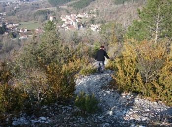
• 6,4km descente prévoir bâton

Randonnée Marche Saint-Vincent-Rive-d'Olt - Point de vue Saint Vincent Rive d'Olt - Photo
Marche 8.087
Km

Marche

Difficile
Saint-Vincent-Rive-d'Olt, Occitanie, Lot, France
8,1 km | 12,8 km-effort
3h 0min
352 m
352 m
Oui
tracegps

• Circuit praticable toute l'année avec 90% de sentier et de magnifiques points de vue... attention tout de même au dén...

Randonnée Marche Saint-Vincent-Rive-d'Olt - Cournou (Labouysse)_Mader 7.8 - Photo
Marche 7.758
Km

Marche

Très facile
Saint-Vincent-Rive-d'Olt, Occitanie, Lot, France
7,8 km | 9,7 km-effort
2h 19min
147 m
144 m
Oui
PariseJL

Randonnée Marche Saint-Vincent-Rive-d'Olt - Cournou Labouysse_Les Roubines 6 - Photo
Marche 6.004
Km

Marche

Très facile
Saint-Vincent-Rive-d'Olt, Occitanie, Lot, France
6 km | 7 km-effort
1h 36min
76 m
78 m
Oui
PariseJL

Randonnée Marche Saint-Vincent-Rive-d'Olt - saint - Photo
Marche 52.802
Km

Marche

Très facile
Saint-Vincent-Rive-d'Olt, Occitanie, Lot, France
53 km | 76 km-effort
4h 40min
1753 m
1734 m
Non
saligne

Randonnée Marche Saint-Vincent-Rive-d'Olt - Roques - Photo
Marche 19.302
Km

Marche

Très facile
Saint-Vincent-Rive-d'Olt, Occitanie, Lot, France
19,3 km | 28 km-effort
5h 51min
652 m
651 m
Oui
philou6351

8 randonnées affichées sur 8

Application GPS de randonnée GRATUITE

Logo SityTrail SityTrail

IGN / Instituts géographiques

Télécharger SityTrail sur l'App Store Télécharger SityTrail sur Google Play

Logo SityTrail SityTrail World

Le monde est à vous

Télécharger SityTrail sur l'App Store Télécharger SityTrail sur Google Play Télécharger SityTrail sur Huawei AppGallery

Activités

Fermer
Mes abonnements