Randonnée V.T.T. Gabriac - Gabriac/Cruejouls VTT - Photo

Gabriac/Cruejouls VTT

 Strabidja
Strabidja

Utilisateur

© OpenStreetMap contributors
Longueur
Longueur
13 km
Altitude max
Altitude max
654 m
Dénivelé positif
Dénivelé positif
246 m
Km-Effort
Km-Effort  
16,3 km
Altitude min
Altitude min
542 m
Dénivelé négatif
Dénivelé négatif
245 m
Boucle
Boucle
Oui
Date de création :
2019-04-02 06:02:22.488
Dernière modification :
2019-04-02 06:02:22.488

(0 Avis)

V.T.T.
V.T.T.
1h30
Difficulté : Facile

Scannez ce code QR pour ouvrir la randonnée dans l'application SityTrail

Application GPS de randonnée GRATUITE

Logo SityTrail SityTrail

IGN / Instituts géographiques

Télécharger SityTrail sur l'App Store Télécharger SityTrail sur Google Play

Logo SityTrail SityTrail World

Le monde est à vous

Télécharger SityTrail sur l'App Store Télécharger SityTrail sur Google Play Télécharger SityTrail sur Huawei AppGallery

À propos

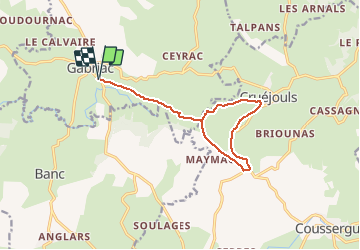
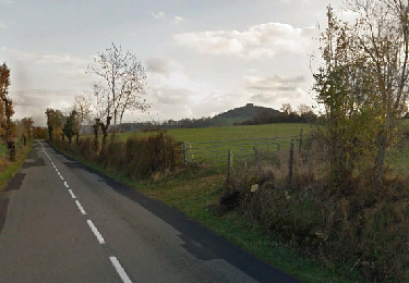
Randonnée V.T.T. de 13 km à découvrir à Occitanie, Aveyron, Gabriac. Cette randonnée est proposée par Strabidja.

Description

TEST -1ère création d'un parcours entre Gabriac et Cruéjouls.

Profil altimétrique

Localisation

Pays :
France
Région :
Occitanie
Département/Province :
Aveyron
Commune :
Gabriac
Localité :
Unknown
Départ:(Dec)
Départ:(UTM)
483820 ; 4921809 (31T) N.

Randonnées à proximité

Randonnée Marche Bertholène - les bourines - Photo
Marche
Lacaze

Marche

Facile
Bertholène, Occitanie, Aveyron, France
9 km | 11 km-effort
2h 33min
Oui
Randonnée Marche Bertholène - les bourines - Photo
Marche
Lacaze

Marche

Facile
(1)
Bertholène, Occitanie, Aveyron, France
9 km | 11 km-effort
2h 33min
Oui
Randonnée A pied Espalion - Biounac, 4,5km  - Photo
A pied
Strabidja

A pied

Très facile
(1)
Espalion, Occitanie, Aveyron, France
4,5 km | 5,4 km-effort
1h 15min
Oui
Randonnée Marche Palmas d'Aveyron - Tour du village de Cruejouls - Photo
Marche
tracegps

Marche

Facile
Palmas d'Aveyron, Occitanie, Aveyron, France
1,5 km | 1,7 km-effort
30min
Oui
Randonnée A pied Gabriac - BIOUNAC/CONDOURNAC 3.8KM - Photo
A pied
Strabidja

A pied

Facile
Gabriac, Occitanie, Aveyron, France
3,8 km | 4,7 km-effort
Inconnu
Oui
Randonnée Marche Gabriac - Les 5 clochers - Photo
Marche
bbertrand974

Marche

Facile
Gabriac, Occitanie, Aveyron, France
11,6 km | 14,4 km-effort
3h 7min
Oui
Randonnée Marche Gabriac - Cruejouls - Photo
Marche
bbertrand974

Marche

Très facile
Gabriac, Occitanie, Aveyron, France
9,8 km | 12,9 km-effort
2h 44min
Oui
Randonnée Autre activité Bozouls - Coudournac - Photo
Autre activité
Lacaze

Autre activité

Très facile
Bozouls, Occitanie, Aveyron, France
9,1 km | 12,1 km-effort
5min
Non
Randonnée Marche Bozouls - coudournac  - Photo
Marche
bauxtilou

Marche

Très facile
Bozouls, Occitanie, Aveyron, France
9,3 km | 12,2 km-effort
3h 4min
Oui


Fermer
Mes abonnements