Randonnée Marche Arras-en-Lavedan - Cabaliros depuis Val d'Azun - Photo
 pffrench
pffrench

Utilisateur

© OpenStreetMap contributors
Longueur
Longueur
11,2 km
Altitude max
Altitude max
2326 m
Dénivelé positif
Dénivelé positif
737 m
Km-Effort
Km-Effort  
21 km
Altitude min
Altitude min
1613 m
Dénivelé négatif
Dénivelé négatif
737 m
Boucle
Boucle
Oui
Date de création :
2019-01-15 13:58:16.078
Dernière modification :
2019-01-15 13:58:16.078

(0 Avis)

Marche
Marche
7h57
Difficulté : Facile

Scannez ce code QR pour ouvrir la randonnée dans l'application SityTrail

Application GPS de randonnée GRATUITE

Logo SityTrail SityTrail

IGN / Instituts géographiques

Télécharger SityTrail sur l'App Store Télécharger SityTrail sur Google Play

Logo SityTrail SityTrail World

Le monde est à vous

Télécharger SityTrail sur l'App Store Télécharger SityTrail sur Google Play Télécharger SityTrail sur Huawei AppGallery

À propos

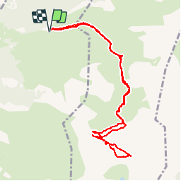
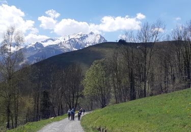
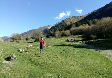
Randonnée Marche de 11,2 km à découvrir à Occitanie, Hautes-Pyrénées, Arras-en-Lavedan. Cette randonnée est proposée par pffrench.

Description

problème de choix itineraires . prendre celui du retour, indiqué par las punaises rouges, "tracé confortable".
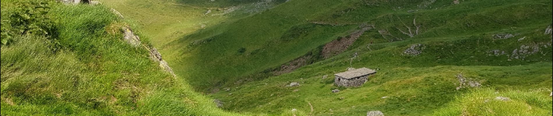
Par ailleurs, magnifique table d'orientation au sommet.
Eviter de se faire prendre par la mer de nuages, l'identification du chemin dans le brouillard peut etre difficile.

Profil altimétrique

Photos

Points d'intérêt

Point d'intérêt Arcizans-Avant - Tracé confortable - Photo
pffrench
ARCIZANS-AVANT 
Point d'intérêt Arcizans-Avant - Tracé confortable - Photo
pffrench
ARCIZANS-AVANT 
Point d'intérêt Arcizans-Avant - Tracé confortable - Photo
pffrench
ARCIZANS-AVANT 

Localisation

Pays :
France
Région :
Occitanie
Département/Province :
Hautes-Pyrénées
Commune :
Arras-en-Lavedan
Localité :
Unknown
Départ:(Dec)
Départ:(UTM)
732829 ; 4759465 (30T) N.

Randonnées à proximité

Randonnée Marche Arcizans-Dessus - la fontaine de Nabias - Photo
Marche
bernardbelmas

Marche

Très facile
(1)
Arcizans-Dessus, Occitanie, Hautes-Pyrénées, France
4,2 km | 6,8 km-effort
1h 40min
Oui
Randonnée Raquettes à neige Aucun - Le Soum de Berducou - Photo
Raquettes à neige
tracegps

Raquettes à neige

Moyen
(1)
Aucun, Occitanie, Hautes-Pyrénées, France
5,3 km | 9,6 km-effort
3h 15min
Oui
Randonnée Marche Estaing - Les Viellettes - Estaing - Photo
Marche
tracegps

Marche

Difficile
(1)
Estaing, Occitanie, Hautes-Pyrénées, France
13,1 km | 24 km-effort
4h 0min
Oui
Randonnée Marche Gaillagos - GAILLAGOS / Couret / Couraduque en boucle reco G3 - Photo
Marche
GUIDE
marmotte65

Marche

Difficile
Gaillagos, Occitanie, Hautes-Pyrénées, France
8,4 km | 14,3 km-effort
2h 30min
Oui
Randonnée A pied Aucun - AUCUN Couraduque  Le Berbeillet autrement G3 2976337 - Photo
A pied
GUIDE
marmotte65

A pied

Facile
Aucun, Occitanie, Hautes-Pyrénées, France
9,5 km | 14,2 km-effort
2h 13min
Oui
Randonnée Sports d'hiver Aucun - couraduc soulor - Photo
Sports d'hiver
ehresmann

Sports d'hiver

Difficile
(1)
Aucun, Occitanie, Hautes-Pyrénées, France
34 km | 45 km-effort
2h 31min
Oui
Randonnée Sports d'hiver Aucun - Bazes soulor - Photo
Sports d'hiver
ehresmann

Sports d'hiver

Moyen
(1)
Aucun, Occitanie, Hautes-Pyrénées, France
25 km | 34 km-effort
2h 4min
Oui
Randonnée Marche Gaillagos - GAILLAGOS Col de Couret Couraduque en boucle G3 du 21/04/2023
Marche
GUIDE
marmotte65

Marche

Difficile
Gaillagos, Occitanie, Hautes-Pyrénées, France
8,2 km | 14,2 km-effort
2h 46min
Oui
Randonnée Marche Estaing - ESTAING autour du lac - Photo
Marche
GUIDE
marmotte65

Marche

Facile
Estaing, Occitanie, Hautes-Pyrénées, France
3,7 km | 5,3 km-effort
1h 9min
Oui


Fermer
Mes abonnements