


Oderen église-Refuge AN Treh

JCLUTT
Utilisateur
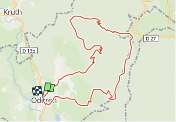

Longueur
11,4 km

Altitude max
1127 m

Dénivelé positif
690 m
Km-Effort
21 km

Altitude min
461 m

Dénivelé négatif
691 m
Boucle
Oui
Date de création :
2019-05-21 17:17:05.92
Dernière modification :
2021-05-26 09:54:26.993
--
Difficulté : Moyen

Application GPS de randonnée GRATUITE
 SityTrail
IGN / Instituts géographiques
SityTrail Plus
Le monde est à vous
À propos
Randonnée Marche de 11,4 km à découvrir à Grand Est, Haut-Rhin, Oderen. Cette randonnée est proposée par JCLUTT.
Localisation
Pays :
France
Région :
Grand Est
Département/Province :
Haut-Rhin
Commune :
Oderen
Localité :
Unknown
Départ:(Dec)
Départ:(UTM)
348709 ; 5308298 (32T) N.
Commentaires