Randonnée V.T.T. Rouffach - Rando Rouffach - Photo
 tracegps
tracegps

Utilisateur

© OpenStreetMap contributors
Longueur
Longueur
16 km
Altitude max
Altitude max
433 m
Dénivelé positif
Dénivelé positif
366 m
Km-Effort
Km-Effort  
21 km
Altitude min
Altitude min
202 m
Dénivelé négatif
Dénivelé négatif
365 m
Boucle
Boucle
Oui
Date de création :
2014-12-10 00:00:00.0
Dernière modification :
2014-12-10 00:00:00.0

(0 Avis)

V.T.T.
V.T.T.
1h30
Difficulté : Moyen

Scannez ce code QR pour ouvrir la randonnée dans l'application SityTrail

Application GPS de randonnée GRATUITE

Logo SityTrail SityTrail

IGN / Instituts géographiques

Télécharger SityTrail sur l'App Store Télécharger SityTrail sur Google Play

Logo SityTrail SityTrail World

Le monde est à vous

Télécharger SityTrail sur l'App Store Télécharger SityTrail sur Google Play Télécharger SityTrail sur Huawei AppGallery

À propos

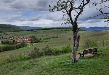
Randonnée V.T.T. de 16 km à découvrir à Grand Est, Haut-Rhin, Rouffach. Cette randonnée est proposée par tracegps.

Description

Voici un petit circuit de rando bien sympa malgré un finish sur route. Pourquoi ne pas l'améliorer ?! Un passage bien sympa en plein cœur d'une abbaye en pleine montagne.

Profil altimétrique

Localisation

Pays :
France
Région :
Grand Est
Département/Province :
Haut-Rhin
Commune :
Rouffach
Localité :
Unknown
Départ:(Dec)
Départ:(UTM)
372073 ; 5311782 (32T) N.

Randonnées à proximité

Randonnée Marche Westhalten - 2021 03 04 Westhalten - Photo
Marche
E.BURCK

Marche

Facile
(1)
Westhalten, Grand Est, Haut-Rhin, France
7,7 km | 11,3 km-effort
2h 21min
Oui
Randonnée Marche Rouffach - 68 Rouffach- Schauenberg variante
Marche
E.BURCK

Marche

Facile
(1)
Rouffach, Grand Est, Haut-Rhin, France
10,6 km | 15,3 km-effort
3h 29min
Oui
Randonnée V.T.T. Guebwiller - P4  Circuits du Florival 2021   - Photo
V.T.T.
duchaine.nicolas

V.T.T.

Moyen
(1)
Guebwiller, Grand Est, Haut-Rhin, France
40 km | 53 km-effort
4h 31min
Non
Randonnée Marche Pfaffenheim - Schauenberg 1 - Photo
Marche
regisbodilis

Marche

Facile
(1)
Pfaffenheim, Grand Est, Haut-Rhin, France
10,3 km | 16,5 km-effort
3h 30min
Oui
Randonnée V.T.T. Westhalten - Westhalten - Le tour de la vallée Noble - Photo
V.T.T.
sit68000

V.T.T.

Difficile
(1)
Westhalten, Grand Est, Haut-Rhin, France
24 km | 33 km-effort
2h 30min
Oui
Randonnée Marche Westhalten - WESTHALTEN ZINKOEPHLE - Photo
Marche
MarcOBRECHT

Marche

Moyen
Westhalten, Grand Est, Haut-Rhin, France
10,6 km | 15,3 km-effort
2h 56min
Oui
Randonnée Marche Westhalten - Westhalten - Rouffach  - Photo
Marche
Richard68500

Marche

Difficile
Westhalten, Grand Est, Haut-Rhin, France
8,9 km | 13 km-effort
3h 22min
Oui
Randonnée V.T.T. Rouffach - Rouffach - Guebwiller - Photo
V.T.T.
duchaine.nicolas

V.T.T.

Facile
Rouffach, Grand Est, Haut-Rhin, France
32 km | 44 km-effort
3h 3min
Non
Randonnée Marche Orschwihr - Boucle pour Soultzmatt - Photo
Marche
GuyVachet

Marche

Moyen
Orschwihr, Grand Est, Haut-Rhin, France
12,4 km | 16,5 km-effort
4h 4min
Oui


Fermer
Mes abonnements