


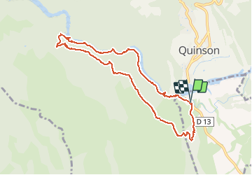
ancien canal du verdon

bernir
Utilisateur

Longueur
9,6 km

Altitude max
548 m

Dénivelé positif
350 m
Km-Effort
14,3 km

Altitude min
368 m

Dénivelé négatif
349 m
Boucle
Oui
Date de création :
2019-01-15 16:35:25.704
Dernière modification :
2019-01-15 16:35:25.704
2h59
Difficulté : Moyen

Application GPS de randonnée GRATUITE
 SityTrail
IGN / Instituts géographiques
SityTrail Plus
Le monde est à vous
À propos
Randonnée Marche de 9,6 km à découvrir à Provence-Alpes-Côte d'Azur, Var, Montmeyan. Cette randonnée est proposée par bernir.


Localisation
Pays :
France
Région :
Provence-Alpes-Côte d'Azur
Département/Province :
Var
Commune :
Montmeyan
Localité :
Unknown
Départ:(Dec)
Départ:(UTM)
261275 ; 4842008 (32T) N.
Commentaires