Randonnée Marche Saint-Césaire - La Vallée du Coran - St Bris des Bois - Photo

La Vallée du Coran - St Bris des Bois

 tracegps
tracegps

Utilisateur

© OpenStreetMap contributors
Longueur
Longueur
7,4 km
Altitude max
Altitude max
54 m
Dénivelé positif
Dénivelé positif
113 m
Km-Effort
Km-Effort  
8,9 km
Altitude min
Altitude min
22 m
Dénivelé négatif
Dénivelé négatif
113 m
Boucle
Boucle
Oui
Date de création :
2014-12-10 00:00:00.0
Dernière modification :
2014-12-10 00:00:00.0

(0 Avis)

Marche
Marche
2h00
Difficulté : Moyen

Scannez ce code QR pour ouvrir la randonnée dans l'application SityTrail

Application GPS de randonnée GRATUITE

Logo SityTrail SityTrail

IGN / Instituts géographiques

Télécharger SityTrail sur l'App Store Télécharger SityTrail sur Google Play

Logo SityTrail SityTrail World

Le monde est à vous

Télécharger SityTrail sur l'App Store Télécharger SityTrail sur Google Play Télécharger SityTrail sur Huawei AppGallery

À propos

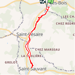
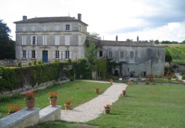
Randonnée Marche de 7,4 km à découvrir à Nouvelle-Aquitaine, Charente-Maritime, Saint-Césaire. Cette randonnée est proposée par tracegps.

Description

Circuit dans la vallée du Coran, affluent de la Charente. une visite du Paléosite est possible sur le trajet.

Profil altimétrique

Photos

Localisation

Pays :
France
Région :
Nouvelle-Aquitaine
Département/Province :
Charente-Maritime
Commune :
Saint-Césaire
Localité :
Unknown
Départ:(Dec)
Départ:(UTM)
694695 ; 5070873 (30T) N.

Randonnées à proximité

Randonnée Cheval La Chapelle-des-Pots - Circuit des potiers - La Chapelle des Pots - Photo
Cheval
tracegps

Cheval

Facile
(1)
La Chapelle-des-Pots, Nouvelle-Aquitaine, Charente-Maritime, France
7,2 km | 8,5 km-effort
1h 19min
Oui
Randonnée Marche La Chapelle-des-Pots - la Chapelle des Pots ( D ROUSSET) - Photo
Marche
Claudinette17

Marche

Moyen
(1)
La Chapelle-des-Pots, Nouvelle-Aquitaine, Charente-Maritime, France
7,8 km | 8,8 km-effort
2h 40min
Oui
Randonnée Marche La Chapelle-des-Pots - La Chapelle des Pots - Asphodèles - Photo
Marche
Claudinette17

Marche

Facile
(1)
La Chapelle-des-Pots, Nouvelle-Aquitaine, Charente-Maritime, France
7,4 km | 8,7 km-effort
2h 5min
Oui
Randonnée V.T.T. La Chapelle-des-Pots - Circuit des potiers - La Chapelle des Pots - Photo
V.T.T.
tracegps

V.T.T.

Facile
La Chapelle-des-Pots, Nouvelle-Aquitaine, Charente-Maritime, France
7,2 km | 8,5 km-effort
34min
Oui
Randonnée Marche La Chapelle-des-Pots - Circuit des potiers - La Chapelle des Pots - Photo
Marche
tracegps

Marche

Moyen
La Chapelle-des-Pots, Nouvelle-Aquitaine, Charente-Maritime, France
7,2 km | 8,5 km-effort
2h 0min
Oui
Randonnée Marche Vénérand - venerand - Photo
Marche
jpland17800

Marche

Très difficile
Vénérand, Nouvelle-Aquitaine, Charente-Maritime, France
24 km | 28 km-effort
6h 21min
Non
Randonnée Marche La Chapelle-des-Pots - la chapelle des pots - Photo
Marche
niniroro51

Marche

Moyen
La Chapelle-des-Pots, Nouvelle-Aquitaine, Charente-Maritime, France
5,9 km | 7,1 km-effort
2h 2min
Oui
Randonnée Course à pied Villars-les-Bois - Course de côtes - Photo
Course à pied
Arts Terre

Course à pied

Difficile
Villars-les-Bois, Nouvelle-Aquitaine, Charente-Maritime, France
15,1 km | 19,2 km-effort
Inconnu
Oui
Randonnée Marche Saint-Césaire - Saint Bris des Bois - Photo
Marche
reva17

Marche

Moyen
Saint-Césaire, Nouvelle-Aquitaine, Charente-Maritime, France
13,2 km | 15,7 km-effort
3h 30min
Oui


Fermer
Mes abonnements