Randonnée V.T.T. Plouider - Pont du Chatel boucle 14 - Photo

Pont du Chatel boucle 14

 tracegps
tracegps

Utilisateur

© OpenStreetMap contributors
Longueur
Longueur
6,5 km
Altitude max
Altitude max
72 m
Dénivelé positif
Dénivelé positif
108 m
Km-Effort
Km-Effort  
7,9 km
Altitude min
Altitude min
4 m
Dénivelé négatif
Dénivelé négatif
107 m
Boucle
Boucle
Oui
Date de création :
2014-12-10 00:00:00.0
Dernière modification :
2014-12-10 00:00:00.0

(0 Avis)

V.T.T.
V.T.T.
19m
Difficulté : Facile

Scannez ce code QR pour ouvrir la randonnée dans l'application SityTrail

Application GPS de randonnée GRATUITE

Logo SityTrail SityTrail

IGN / Instituts géographiques

Télécharger SityTrail sur l'App Store Télécharger SityTrail sur Google Play

Logo SityTrail SityTrail World

Le monde est à vous

Télécharger SityTrail sur l'App Store Télécharger SityTrail sur Google Play Télécharger SityTrail sur Huawei AppGallery

À propos

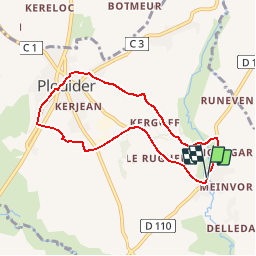
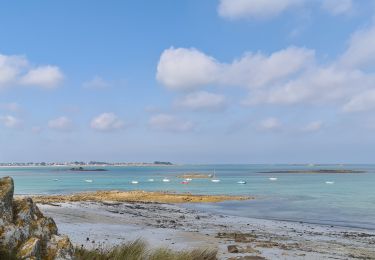
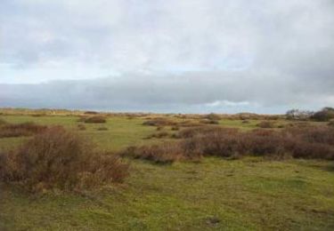
Randonnée V.T.T. de 6,5 km à découvrir à Bretagne, Finistère, Plouider. Cette randonnée est proposée par tracegps.

Description

Depuis Pont du Chatel remontée vers le bourg de Plouider et bifurcation vers l'ouest en direction d'un site avec d'anciens blockhaus puis remontée dans le bourg de Plouider et retour vers pont du Chatel au travers de chemins creux.

Profil altimétrique

Localisation

Pays :
France
Région :
Bretagne
Département/Province :
Finistère
Commune :
Plouider
Localité :
Unknown
Départ:(Dec)
Départ:(UTM)
406038 ; 5383488 (30U) N.

Randonnées à proximité

Randonnée Marche nordique Saint-Méen - st méen - Photo
Marche nordique
elianette

Marche nordique

Très facile
Saint-Méen, Bretagne, Finistère, France
14,9 km | 17,2 km-effort
2h 57min
Oui
Randonnée A pied Plouider - Poul Sant Dider - Photo
A pied
PRO

A pied

Facile
Plouider, Bretagne, Finistère, France
6,3 km | 7,4 km-effort
1h 41min
Oui
Randonnée Marche Tréflez - Dunes de Kerrema - Photo
Marche
bitiba

Marche

Tréflez, Bretagne, Finistère, France
4,5 km | 4,7 km-effort
1h 21min
Oui
Randonnée Cyclotourisme Tréflez - de Goulven à St Michel  - Photo
Cyclotourisme
nadd73

Cyclotourisme

Moyen
Tréflez, Bretagne, Finistère, France
44 km | 49 km-effort
4h 36min
Non
Randonnée Marche Tréflez - rando Bretagne 22/09/2020 - Photo
Marche
dudu79

Marche

Très facile
Tréflez, Bretagne, Finistère, France
9,2 km | 9,8 km-effort
2h 31min
Oui
Randonnée Marche Tréflez - La maison des dunes de Kerrema - Photo
Marche
bitiba

Marche

Facile
Tréflez, Bretagne, Finistère, France
3,6 km | 3,8 km-effort
1h 10min
Oui
Randonnée Marche Goulven - GR 34® de Goulven à Guissény - Photo
Marche
tracegps

Marche

Difficile
Goulven, Bretagne, Finistère, France
28 km | 30 km-effort
5h 30min
Non
Randonnée Marche Tréflez - Dunes de Ker Emma  - Photo
Marche
tracegps

Marche

Moyen
Tréflez, Bretagne, Finistère, France
13,6 km | 14,2 km-effort
2h 34min
Oui
Randonnée A pied Plounéventer - Circuit de Kerillien - Photo
A pied
PRO

A pied

Facile
Plounéventer, Bretagne, Finistère, France
6,1 km | 7,3 km-effort
1h 39min
Non


Fermer
Mes abonnements