Randonnée Marche Saint-Amand-Montrond - Remise en forme le long du Canal de Berry - Saint Amand Montrond - Photo

Remise en forme le long du Canal de Berry - Saint Amand Montrond

 tracegps
tracegps

Utilisateur

© OpenStreetMap contributors
Longueur
Longueur
12,4 km
Altitude max
Altitude max
167 m
Dénivelé positif
Dénivelé positif
59 m
Km-Effort
Km-Effort  
13,2 km
Altitude min
Altitude min
155 m
Dénivelé négatif
Dénivelé négatif
59 m
Boucle
Boucle
Oui
Date de création :
2014-12-10 00:00:00.0
Dernière modification :
2014-12-10 00:00:00.0

(0 Avis)

Marche
Marche
2h10
Difficulté : Moyen

Scannez ce code QR pour ouvrir la randonnée dans l'application SityTrail

Application GPS de randonnée GRATUITE

Logo SityTrail SityTrail

IGN / Instituts géographiques

Télécharger SityTrail sur l'App Store Télécharger SityTrail sur Google Play

Logo SityTrail SityTrail World

Le monde est à vous

Télécharger SityTrail sur l'App Store Télécharger SityTrail sur Google Play Télécharger SityTrail sur Huawei AppGallery

À propos

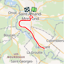
Randonnée Marche de 12,4 km à découvrir à Centre-Val de Loire, Cher, Saint-Amand-Montrond. Cette randonnée est proposée par tracegps.

Description

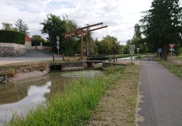
Circuit de remise en forme par la marche. Pas de dénivelé. Petite partie du circuit sur route pour arriver ensuite sur un long chemin pédestre le long du canal parsemé d'arbres. Vitesse moyenne pour faire le parcours en 2h10 : 5,7km/h Parcours agréable loin de la circulation.

Profil altimétrique

Photos

Localisation

Pays :
France
Région :
Centre-Val de Loire
Département/Province :
Cher
Commune :
Saint-Amand-Montrond
Localité :
Unknown
Départ:(Dec)
Départ:(UTM)
462186 ; 5174572 (31T) N.

Randonnées à proximité

Randonnée V.T.C. Orval - saint amand montrond vallon  - Photo
V.T.C.
dgrimault

V.T.C.

Très facile
Orval, Centre-Val de Loire, Cher, France
28 km | 31 km-effort
1h 27min
Non
Randonnée Marche Saint-Amand-Montrond - Compostelle etape 9 et 10 - Photo
Marche
maginot

Marche

Moyen
Saint-Amand-Montrond, Centre-Val de Loire, Cher, France
63 km | 72 km-effort
16h 19min
Non
Randonnée V.T.T. Saint-Amand-Montrond - Tour du lac de Virlay - Photo
V.T.T.
Pat_83200

V.T.T.

Très facile
Saint-Amand-Montrond, Centre-Val de Loire, Cher, France
5,9 km | 6,2 km-effort
33min
Oui
Randonnée Marche Drevant - drevant - Photo
Marche
fournieralain

Marche

Très facile
Drevant, Centre-Val de Loire, Cher, France
4,5 km | 5,3 km-effort
1h 26min
Non
Randonnée Marche Saint-Amand-Montrond - canal du Berry - Photo
Marche
fournieralain

Marche

Très facile
Saint-Amand-Montrond, Centre-Val de Loire, Cher, France
7,7 km | 8,1 km-effort
1h 58min
Oui
Randonnée V.T.C. Saint-Amand-Montrond - le Veurdre  - Photo
V.T.C.
dgrimault

V.T.C.

Très facile
Saint-Amand-Montrond, Centre-Val de Loire, Cher, France
61 km | 66 km-effort
4h 16min
Non
Randonnée V.T.T. Saint-Amand-Montrond - 3 Saint Amand Montrond-Neuvy-St Jacques de Compostelle - Photo
V.T.T.
nicolas54230

V.T.T.

Difficile
Saint-Amand-Montrond, Centre-Val de Loire, Cher, France
107 km | 123 km-effort
8h 1min
Non
Randonnée Marche Saint-Amand-Montrond - la Tranchasse - Photo
Marche
charcamval

Marche

Très facile
Saint-Amand-Montrond, Centre-Val de Loire, Cher, France
31 km | 34 km-effort
Inconnu
Oui
Randonnée Marche Saint-Amand-Montrond - randonnée dt amand - Photo
Marche
lololen33

Marche

Facile
Saint-Amand-Montrond, Centre-Val de Loire, Cher, France
20 km | 23 km-effort
3h 8min
Oui


Fermer
Mes abonnements