Randonnée V.T.T. Samatan - VTT autour de Samatan et Lombez - Photo

VTT autour de Samatan et Lombez

 tracegps
tracegps

Utilisateur

© OpenStreetMap contributors
Longueur
Longueur
36 km
Altitude max
Altitude max
269 m
Dénivelé positif
Dénivelé positif
591 m
Km-Effort
Km-Effort  
44 km
Altitude min
Altitude min
164 m
Dénivelé négatif
Dénivelé négatif
590 m
Boucle
Boucle
Oui
Date de création :
2014-12-10 00:00:00.0
Dernière modification :
2014-12-10 00:00:00.0

(1 Avis)

V.T.T.
V.T.T.
3h00
Difficulté : Difficile

Scannez ce code QR pour ouvrir la randonnée dans l'application SityTrail

Application GPS de randonnée GRATUITE

Logo SityTrail SityTrail

IGN / Instituts géographiques

Télécharger SityTrail sur l'App Store Télécharger SityTrail sur Google Play

Logo SityTrail SityTrail World

Le monde est à vous

Télécharger SityTrail sur l'App Store Télécharger SityTrail sur Google Play Télécharger SityTrail sur Huawei AppGallery

À propos

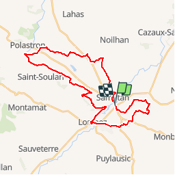
Randonnée V.T.T. de 36 km à découvrir à Occitanie, Gers, Samatan. Cette randonnée est proposée par tracegps.

Description

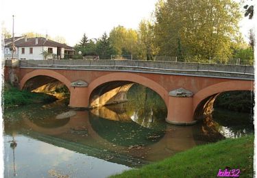
Cette boucle offre de beaux points de vue sur les coteaux du Gers, et en arrière plan les Pyrénées, par temps clair. Au pays du foie gras, prévoir un sac à dos pour quelques emplettes dans les fermes traversées ! Sur le parcours se succèdent châteaux et belles demeures, bois et coteaux. Aucune difficulté technique. Éviter toutefois les périodes humides. Quelques gués obligent à mouiller les chaussures. Chacun de ces gués sont faciles à traverser à vélo, alors ne pas hésiter à rester sur la selle ! Bonne balade !

Profil altimétrique

Photos

Localisation

Pays :
France
Région :
Occitanie
Département/Province :
Gers
Commune :
Samatan
Localité :
Unknown
Départ:(Dec)
Départ:(UTM)
332926 ; 4817196 (31T) N.

Commentaires

Veuillez vous connecter pour laisser un commentaire ou une note


Belle randonnée Quelques passages passent par des propriétés privées ou n'existent plus mais il existe des alternatives sans faire trop de détours


Randonnées à proximité

Randonnée Marche Monblanc - Monblanc - Photo
Marche
pidjam

Marche

Facile
(1)
Monblanc, Occitanie, Gers, France
11,7 km | 15 km-effort
2h 41min
Oui
Randonnée Marche Lombez - Lombez 1 - Photo
Marche
pidjam

Marche

Très facile
Lombez, Occitanie, Gers, France
10,1 km | 11,6 km-effort
2h 32min
Oui
Randonnée Marche Lombez - Balade en bord de Save - Lombez - Photo
Marche
tracegps

Marche

Facile
Lombez, Occitanie, Gers, France
6,3 km | 6,8 km-effort
1h 34min
Oui
Randonnée Marche Lombez - Autour du Château de Barbet et du Golf (Grand Circuit) - Lombez - Photo
Marche
tracegps

Marche

Moyen
Lombez, Occitanie, Gers, France
9 km | 11,2 km-effort
2h 15min
Oui
Randonnée Marche Lombez - Sur les traces du dragon - Lombez - Photo
Marche
tracegps

Marche

Moyen
Lombez, Occitanie, Gers, France
8,5 km | 10,7 km-effort
2h 10min
Oui
Randonnée Marche Samatan - Samatan 2020 - Photo
Marche
robinier

Marche

Samatan, Occitanie, Gers, France
6,8 km | 7,4 km-effort
2h 17min
Oui
Randonnée Marche Lombez - De la Ramondère au lieu-dit en Maraillot - Lombez - Photo
Marche
tracegps

Marche

Moyen
Lombez, Occitanie, Gers, France
8,1 km | 9,5 km-effort
2h 4min
Oui
Randonnée Marche Lombez - Autour du Château de Barbet et du Golf (Petit Circuit) - Lombez - Photo
Marche
tracegps

Marche

Facile
Lombez, Occitanie, Gers, France
8,9 km | 11,1 km-effort
1h 49min
Oui
Randonnée Marche Lombez - lombez circuit du dragon - Photo
Marche
pidjam

Marche

Facile
Lombez, Occitanie, Gers, France
9 km | 11,2 km-effort
2h 27min
Oui


Fermer
Mes abonnements