Randonnée Marche Sainte-Foy-de-Peyrolières - Lac et bois autour de Sainte Foy de Peyrolières - Photo

Lac et bois autour de Sainte Foy de Peyrolières

 tracegps
tracegps

Utilisateur

© OpenStreetMap contributors
Longueur
Longueur
9 km
Altitude max
Altitude max
324 m
Dénivelé positif
Dénivelé positif
165 m
Km-Effort
Km-Effort  
11,2 km
Altitude min
Altitude min
230 m
Dénivelé négatif
Dénivelé négatif
164 m
Boucle
Boucle
Oui
Date de création :
2014-12-10 00:00:00.0
Dernière modification :
2014-12-10 00:00:00.0

(0 Avis)

Marche
Marche
2h30
Difficulté : Facile

Scannez ce code QR pour ouvrir la randonnée dans l'application SityTrail

Application GPS de randonnée GRATUITE

Logo SityTrail SityTrail

IGN / Instituts géographiques

Télécharger SityTrail sur l'App Store Télécharger SityTrail sur Google Play

Logo SityTrail SityTrail World

Le monde est à vous

Télécharger SityTrail sur l'App Store Télécharger SityTrail sur Google Play Télécharger SityTrail sur Huawei AppGallery

À propos

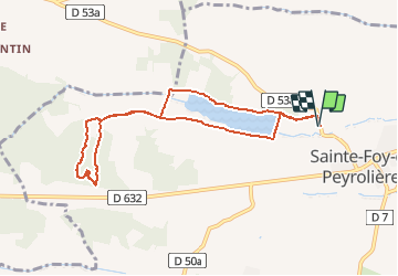
Randonnée Marche de 9 km à découvrir à Occitanie, Haute-Garonne, Sainte-Foy-de-Peyrolières. Cette randonnée est proposée par tracegps.

Description

Randonnée à Ste Foy de Peyrolieres. Départ le long du terrain de tennis, parking devant le stade. Rando agréable, à faire en famille, accessible a tous. Attention à l'aller après la portion de bitume, en entrant dans le bois, il y a de nombreuses ruches sur votre droite.

Profil altimétrique

Photos

Localisation

Pays :
France
Région :
Occitanie
Département/Province :
Haute-Garonne
Commune :
Sainte-Foy-de-Peyrolières
Localité :
Unknown
Départ:(Dec)
Départ:(UTM)
349420 ; 4817721 (31T) N.

Randonnées à proximité

Randonnée Marche Saiguède - Raide de Saiguède - Photo
Marche
tracegps

Marche

Difficile
(1)
Saiguède, Occitanie, Haute-Garonne, France
19 km | 23 km-effort
4h 0min
Oui
Randonnée Marche Sainte-Foy-de-Peyrolières - RANDO-Ste Foy Téléthon 2012 - Photo
Marche
Polo-31

Marche

Facile
Sainte-Foy-de-Peyrolières, Occitanie, Haute-Garonne, France
8 km | 9,3 km-effort
2h 2min
Oui
Randonnée Marche Sainte-Foy-de-Peyrolières - Ste Foy de Peyrolières 13 Avril 2020 - Photo
Marche
daniel3157

Marche

Facile
Sainte-Foy-de-Peyrolières, Occitanie, Haute-Garonne, France
16,4 km | 21 km-effort
4h 58min
Oui
Randonnée Course à pied Saiguède - Raide de Saiguède - Photo
Course à pied
tracegps

Course à pied

Très difficile
Saiguède, Occitanie, Haute-Garonne, France
19 km | 23 km-effort
2h 0min
Oui
Randonnée Marche Sainte-Foy-de-Peyrolières - Randonnée Sainte Foy de Peyrolières  - Photo
Marche
Fafou64

Marche

Sainte-Foy-de-Peyrolières, Occitanie, Haute-Garonne, France
10,7 km | 12,9 km-effort
2h 39min
Oui
Randonnée Marche Saiguède - Saiguède belles vues - Photo
Marche
pidjam

Marche

Très facile
Saiguède, Occitanie, Haute-Garonne, France
8,3 km | 10,5 km-effort
2h 0min
Oui
Randonnée Marche Empeaux - Empeaux circuit cross - Photo
Marche
pidjam

Marche

Facile
Empeaux, Occitanie, Haute-Garonne, France
9,7 km | 12,5 km-effort
2h 40min
Oui
Randonnée Marche Saint-Thomas - st thomas long - Photo
Marche
pidjam

Marche

Facile
Saint-Thomas, Occitanie, Haute-Garonne, France
12,1 km | 15,8 km-effort
3h 22min
Oui
Randonnée Vélo Sainte-Foy-de-Peyrolières - V003-Tour LASSERRE - Photo
Vélo
Polo-31

Vélo

Difficile
Sainte-Foy-de-Peyrolières, Occitanie, Haute-Garonne, France
141 km | 163 km-effort
6h 0min
Oui


Fermer
Mes abonnements