Randonnée Marche Marquefave - De Marquefave  à Lacaugne - Photo

De Marquefave à Lacaugne

 tracegps
tracegps

Utilisateur

© OpenStreetMap contributors
Longueur
Longueur
13,7 km
Altitude max
Altitude max
325 m
Dénivelé positif
Dénivelé positif
340 m
Km-Effort
Km-Effort  
18,2 km
Altitude min
Altitude min
199 m
Dénivelé négatif
Dénivelé négatif
340 m
Boucle
Boucle
Oui
Date de création :
2014-12-10 00:00:00.0
Dernière modification :
2014-12-10 00:00:00.0

(1 Avis)

Marche
Marche
4h00
Difficulté : Moyen

Scannez ce code QR pour ouvrir la randonnée dans l'application SityTrail

Application GPS de randonnée GRATUITE

Logo SityTrail SityTrail

IGN / Instituts géographiques

Télécharger SityTrail sur l'App Store Télécharger SityTrail sur Google Play

Logo SityTrail SityTrail World

Le monde est à vous

Télécharger SityTrail sur l'App Store Télécharger SityTrail sur Google Play Télécharger SityTrail sur Huawei AppGallery

À propos

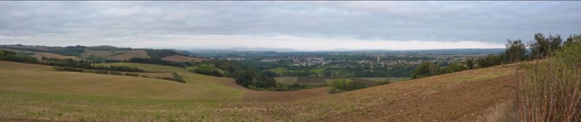
Randonnée Marche de 13,7 km à découvrir à Occitanie, Haute-Garonne, Marquefave. Cette randonnée est proposée par tracegps.

Description

Départ de Marquefave, très beaux point de vues sur les Pyrénées mais un peut trop de bitume a mon gout.

Profil altimétrique

Photos

Localisation

Pays :
France
Région :
Occitanie
Département/Province :
Haute-Garonne
Commune :
Marquefave
Localité :
Unknown
Départ:(Dec)
Départ:(UTM)
357799 ; 4797684 (31T) N.

Commentaires

Veuillez vous connecter pour laisser un commentaire ou une note


site. quitterie


Randonnées à proximité

Randonnée A pied Carbonne - Balade des coteaux - Photo
A pied
PRO

A pied

Facile
Carbonne, Occitanie, Haute-Garonne, France
3,2 km | 5,1 km-effort
1h 9min
Non
Randonnée V.T.T. Longages - viagarona2 - Photo
V.T.T.
ra2000

V.T.T.

Moyen
Longages, Occitanie, Haute-Garonne, France
50 km | 59 km-effort
7h 40min
Non
Randonnée Marche Carbonne - Carbonne abris - Photo
Marche
pidjam

Marche

Très facile
Carbonne, Occitanie, Haute-Garonne, France
11,1 km | 13,3 km-effort
2h 25min
Oui
Randonnée Marche Montgazin - montgazoin - Photo
Marche
Bernard24

Marche

Moyen
Montgazin, Occitanie, Haute-Garonne, France
7,4 km | 0 m-effort
2h 12min
Oui
Randonnée Marche Montaut - montaut fait - Photo
Marche
pidjam

Marche

Facile
Montaut, Occitanie, Haute-Garonne, France
10,2 km | 13,4 km-effort
2h 54min
Oui
Randonnée Marche Montgazin - Montgazin fait 2024 mai - Photo
Marche
pidjam

Marche

Facile
Montgazin, Occitanie, Haute-Garonne, France
7,5 km | 9,6 km-effort
1h 53min
Oui
Randonnée Marche Montgazin - Alain Montgazin - Photo
Marche
ClubAgeHeureux

Marche

Moyen
Montgazin, Occitanie, Haute-Garonne, France
7,5 km | 9,6 km-effort
1h 50min
Oui
Randonnée Marche Montgazin - Montgazin JP  - Photo
Marche
ClubAgeHeureux

Marche

Moyen
Montgazin, Occitanie, Haute-Garonne, France
7,4 km | 9,5 km-effort
2h 5min
Oui
Randonnée Marche Lacaugne - Lacaugne séré fait 2023 - Photo
Marche
pidjam

Marche

Facile
Lacaugne, Occitanie, Haute-Garonne, France
7,5 km | 9,3 km-effort
1h 22min
Non


Fermer
Mes abonnements