


Aulnes Charles Quint 2b

andre.rochet.ar
Utilisateur
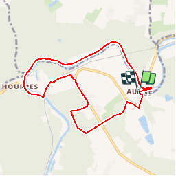

Longueur
7,6 km

Altitude max
191 m

Dénivelé positif
131 m
Km-Effort
9,3 km

Altitude min
106 m

Dénivelé négatif
133 m
Boucle
Oui
Date de création :
2019-01-15 19:08:40.631
Dernière modification :
2019-01-15 19:08:40.631
2h31
Difficulté : Facile

Application GPS de randonnée GRATUITE
 SityTrail
IGN / Instituts géographiques
SityTrail Plus
Le monde est à vous
À propos
Randonnée Marche de 7,6 km à découvrir à Wallonie, Hainaut, Thuin. Cette randonnée est proposée par andre.rochet.ar.
Localisation
Pays :
Belgique
Région :
Wallonie
Département/Province :
Hainaut
Commune :
Thuin
Localité :
Gozée
Départ:(Dec)
Départ:(UTM)
594757 ; 5580232 (31U) N.
Commentaires
Super !