


Le grand Arbois

soca
Utilisateur
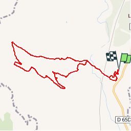

Longueur
9,6 km

Altitude max
245 m

Dénivelé positif
192 m
Km-Effort
12,2 km

Altitude min
126 m

Dénivelé négatif
192 m
Boucle
Oui
Date de création :
2019-01-15 20:10:54.773
Dernière modification :
2019-01-15 20:10:54.773
2h37
Difficulté : Facile

Application GPS de randonnée GRATUITE
 SityTrail
IGN / Instituts géographiques
SityTrail Plus
Le monde est à vous
À propos
Randonnée Marche de 9,6 km à découvrir à Provence-Alpes-Côte d'Azur, Bouches-du-Rhône, Aix-en-Provence. Cette randonnée est proposée par soca.
Localisation
Pays :
France
Région :
Provence-Alpes-Côte d'Azur
Département/Province :
Bouches-du-Rhône
Commune :
Aix-en-Provence
Localité :
Unknown
Départ:(Dec)
Départ:(UTM)
687347 ; 4817722 (31T) N.
Commentaires