Randonnée Marche Tanneron - mimosas 7km - Photo
 mic-13
mic-13

Utilisateur

© OpenStreetMap contributors
Longueur
Longueur
7,1 km
Altitude max
Altitude max
408 m
Dénivelé positif
Dénivelé positif
247 m
Km-Effort
Km-Effort  
10,4 km
Altitude min
Altitude min
192 m
Dénivelé négatif
Dénivelé négatif
245 m
Boucle
Boucle
Oui
Date de création :
2019-04-23 15:55:07.138
Dernière modification :
2019-04-23 15:55:07.185

(1 Avis)

Marche
Marche
2h10
Difficulté : Facile

Scannez ce code QR pour ouvrir la randonnée dans l'application SityTrail

Application GPS de randonnée GRATUITE

Logo SityTrail SityTrail

IGN / Instituts géographiques

Télécharger SityTrail sur l'App Store Télécharger SityTrail sur Google Play

Logo SityTrail SityTrail World

Le monde est à vous

Télécharger SityTrail sur l'App Store Télécharger SityTrail sur Google Play Télécharger SityTrail sur Huawei AppGallery

À propos

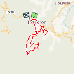
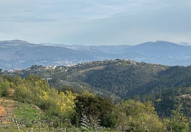
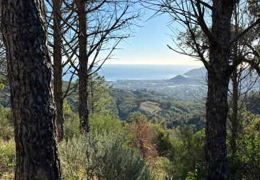
Randonnée Marche de 7,1 km à découvrir à Provence-Alpes-Côte d'Azur, Var, Tanneron. Cette randonnée est proposée par mic-13.

Profil altimétrique

Localisation

Pays :
France
Région :
Provence-Alpes-Côte d'Azur
Département/Province :
Var
Commune :
Tanneron
Localité :
Unknown
Départ:(Dec)
Départ:(UTM)
328195 ; 4828575 (32T) N.

Commentaires

Veuillez vous connecter pour laisser un commentaire ou une note


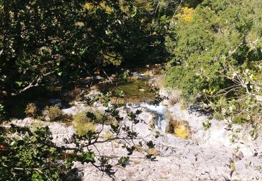
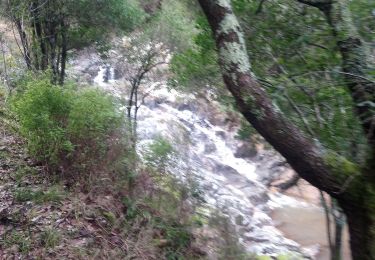
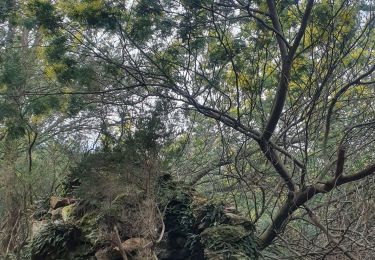
N'y allez pas pour voir du ou des mimosas : il n'y en a pratiquement pas. En outre nous passons le long d'un cours d'eau qu'il faut traverser plusieurs fois, et où l'eau était gelée ( début février). Non, pas terrible la rando.


Randonnées à proximité

Randonnée A pied Tanneron - La chapelle de St Cassien des bois, le pont détruit et au fil de l'eau - Photo
A pied
boulinevelyne

A pied

Facile
(5)
Tanneron, Provence-Alpes-Côte d'Azur, Var, France
7,3 km | 10,3 km-effort
2h 19min
Oui
Randonnée Marche Tanneron - Tanneron les mimosas - Photo
Marche
Michel DUBOIS

Marche

Très facile
(1)
Tanneron, Provence-Alpes-Côte d'Azur, Var, France
12 km | 17,8 km-effort
3h 25min
Oui
Randonnée A pied Le Tignet - Val de Siagne - Photo
A pied
PRO

A pied

Facile
Le Tignet, Provence-Alpes-Côte d'Azur, Alpes-Maritimes, France
6,5 km | 9,5 km-effort
2h 9min
Oui
Randonnée Marche Mandelieu-la-Napoule - Grand Duc Alternatif - Photo
Marche
exxonz

Marche

Très facile
(1)
Mandelieu-la-Napoule, Provence-Alpes-Côte d'Azur, Alpes-Maritimes, France
6,4 km | 9,1 km-effort
2h 0min
Oui
Randonnée sport Tanneron - Tanneron - Photo
sport
alinetpierre

sport

Très facile
Tanneron, Provence-Alpes-Côte d'Azur, Var, France
9,7 km | 13,9 km-effort
Inconnu
Oui
Randonnée Marche Tanneron - 2024-02-16 Tanneron Mimosas - Photo
Marche
GUIDE
Kargil

Marche

Moyen
Tanneron, Provence-Alpes-Côte d'Azur, Var, France
11,1 km | 17,8 km-effort
4h 2min
Oui
Randonnée V.T.T. Tanneron - autour de tanneron - Photo
V.T.T.
papamorse

V.T.T.

Très difficile
(1)
Tanneron, Provence-Alpes-Côte d'Azur, Var, France
30 km | 41 km-effort
2h 50min
Oui
Randonnée sport Mandelieu-la-Napoule - Forêt du Grand Duc - Tanneron - Photo
sport
000837.d1413b0437e14c51ba1cc22669f70606.1648

sport

Très facile
Mandelieu-la-Napoule, Provence-Alpes-Côte d'Azur, Alpes-Maritimes, France
8,4 km | 12,1 km-effort
Inconnu
Oui
Randonnée Marche Le Tignet - circuit du val de Siagne - Photo
Marche
56jj

Marche

Facile
(1)
Le Tignet, Provence-Alpes-Côte d'Azur, Alpes-Maritimes, France
7,4 km | 10,5 km-effort
4h 41min
Oui


Fermer
Mes abonnements