Randonnée Marche Caraman - Etang de l'Orme Blanc - Caraman - Photo

Etang de l'Orme Blanc - Caraman

 tracegps
tracegps

Utilisateur

© OpenStreetMap contributors
Longueur
Longueur
1,6 km
Altitude max
Altitude max
252 m
Dénivelé positif
Dénivelé positif
23 m
Km-Effort
Km-Effort  
1,9 km
Altitude min
Altitude min
221 m
Dénivelé négatif
Dénivelé négatif
29 m
Boucle
Boucle
Oui
Date de création :
2014-12-10 00:00:00.0
Dernière modification :
2014-12-10 00:00:00.0

(0 Avis)

Marche
Marche
34m
Difficulté : Facile

Scannez ce code QR pour ouvrir la randonnée dans l'application SityTrail

Application GPS de randonnée GRATUITE

Logo SityTrail SityTrail

IGN / Instituts géographiques

Télécharger SityTrail sur l'App Store Télécharger SityTrail sur Google Play

Logo SityTrail SityTrail World

Le monde est à vous

Télécharger SityTrail sur l'App Store Télécharger SityTrail sur Google Play Télécharger SityTrail sur Huawei AppGallery

À propos

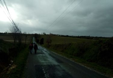
Randonnée Marche de 1,6 km à découvrir à Occitanie, Haute-Garonne, Caraman. Cette randonnée est proposée par tracegps.

Description

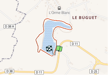
Une petite balade digestive autour de l'Etang de l'Orme Blanc près de Caraman

Profil altimétrique

Photos

Localisation

Pays :
France
Région :
Occitanie
Département/Province :
Haute-Garonne
Commune :
Caraman
Localité :
Unknown
Départ:(Dec)
Départ:(UTM)
398705 ; 4819927 (31T) N.

Randonnées à proximité

Randonnée Marche Albiac - fevrier - Photo
Marche
arnoultjf

Marche

Très facile
Albiac, Occitanie, Haute-Garonne, France
10 km | 11,8 km-effort
1h 59min
Oui
Randonnée Course à pied Aurin - Autour du Lac de St Sernin - Photo
Course à pied
tracegps

Course à pied

Difficile
Aurin, Occitanie, Haute-Garonne, France
15,7 km | 19,5 km-effort
1h 45min
Oui
Randonnée Marche Aurin - Autour du Lac de St Sernin - Photo
Marche
tracegps

Marche

Difficile
Aurin, Occitanie, Haute-Garonne, France
15,7 km | 19,5 km-effort
3h 0min
Oui
Randonnée Course à pied Cambiac - De Cambiac à Auriac sur Vendinelle - Photo
Course à pied
tracegps

Course à pied

Difficile
Cambiac, Occitanie, Haute-Garonne, France
17,2 km | 20 km-effort
1h 40min
Oui
Randonnée Course à pied Maureville - Maureville et son lac - Photo
Course à pied
tracegps

Course à pied

Moyen
Maureville, Occitanie, Haute-Garonne, France
14,4 km | 18,5 km-effort
1h 19min
Oui
Randonnée Marche Maureville - Maureville et son lac - Photo
Marche
tracegps

Marche

Moyen
Maureville, Occitanie, Haute-Garonne, France
14,4 km | 18,5 km-effort
2h 19min
Oui
Randonnée Course à pied Mascarville - De Marceillac à Prunet - Photo
Course à pied
tracegps

Course à pied

Moyen
Mascarville, Occitanie, Haute-Garonne, France
11,5 km | 14,4 km-effort
1h 4min
Oui
Randonnée Marche Caragoudes - caragoudrs - Photo
Marche
arnoultjf

Marche

Moyen
Caragoudes, Occitanie, Haute-Garonne, France
7,4 km | 8,4 km-effort
1h 31min
Oui
Randonnée Marche Ségreville - Boucle du Pistouillé (Ségreville) - Photo
Marche
pidjam

Marche

Moyen
Ségreville, Occitanie, Haute-Garonne, France
12,3 km | 15 km-effort
3h 25min
Oui


Fermer
Mes abonnements