Randonnée V.T.T. Clermont-Soubiran - Clermont-Soubiran, vers la chapelle d'Aureillac - Pays de l'Agenais - Photo

Clermont-Soubiran, vers la chapelle d'Aureillac - Pays de l'Agenais

 tracegps
tracegps

Utilisateur

© OpenStreetMap contributors
Longueur
Longueur
7 km
Altitude max
Altitude max
162 m
Dénivelé positif
Dénivelé positif
218 m
Km-Effort
Km-Effort  
9,9 km
Altitude min
Altitude min
64 m
Dénivelé négatif
Dénivelé négatif
216 m
Boucle
Boucle
Oui
Date de création :
2014-12-10 00:00:00.0
Dernière modification :
2014-12-10 00:00:00.0

(0 Avis)

V.T.T.
V.T.T.
49m
Difficulté : Moyen

Scannez ce code QR pour ouvrir la randonnée dans l'application SityTrail

Application GPS de randonnée GRATUITE

Logo SityTrail SityTrail

IGN / Instituts géographiques

Télécharger SityTrail sur l'App Store Télécharger SityTrail sur Google Play

Logo SityTrail SityTrail World

Le monde est à vous

Télécharger SityTrail sur l'App Store Télécharger SityTrail sur Google Play Télécharger SityTrail sur Huawei AppGallery

À propos

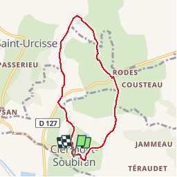
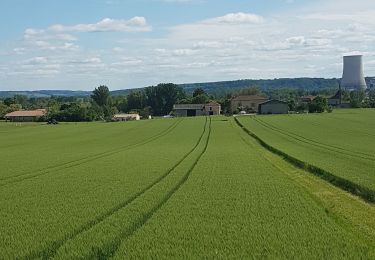
Randonnée V.T.T. de 7 km à découvrir à Nouvelle-Aquitaine, Lot-et-Garonne, Clermont-Soubiran. Cette randonnée est proposée par tracegps.

Description

Clermont Soubiran / Aureillac Cté de Communes des Deux Séounes. Ce circuit court mais physique, par endroits, offre de nombreux points de vue sur les coteaux du Pays de Serres, la vallée de la Garonne et les ondulations des coteaux de Gascogne à l’horizon. La chapelle d’Aureillac, mérite l’attention, même si elle ne peut se découvrir que de l’extérieur. Téléchargez la fiche de cette randonnée sur le site du Tourisme du Lot et Garonne.

Profil altimétrique

Photos

Localisation

Pays :
France
Région :
Nouvelle-Aquitaine
Département/Province :
Lot-et-Garonne
Commune :
Clermont-Soubiran
Localité :
Unknown
Départ:(Dec)
Départ:(UTM)
326583 ; 4889689 (31T) N.

Randonnées à proximité

Randonnée sport Valence - Lundi 22avril 2024 - Photo
sport
cheepewa

sport

Très facile
Valence, Occitanie, Tarn-et-Garonne, France
10,5 km | 12,7 km-effort
Inconnu
Oui
Randonnée sport Valence - Les marcheurs du Pontus 18 avril 2024 - Photo
sport
cheepewa

sport

Très facile
Valence, Occitanie, Tarn-et-Garonne, France
10,8 km | 11,7 km-effort
Inconnu
Oui
Randonnée Marche Clermont-Soubiran - Coteaux depuis maison Roiatti  - Photo
Marche
jlc12

Marche

Moyen
Clermont-Soubiran, Nouvelle-Aquitaine, Lot-et-Garonne, France
4,1 km | 5,5 km-effort
1h 7min
Oui
Randonnée Marche Clermont-Soubiran - coupet autour de labro - Photo
Marche
jlc12

Marche

Moyen
(2)
Clermont-Soubiran, Nouvelle-Aquitaine, Lot-et-Garonne, France
11,5 km | 14,7 km-effort
3h 11min
Oui
Randonnée V.T.T. Donzac - Les sentiers du Brulhois - Donzac - Photo
V.T.T.
tracegps

V.T.T.

Moyen
Donzac, Occitanie, Tarn-et-Garonne, France
40 km | 48 km-effort
2h 45min
Oui
Randonnée V.T.T. Saint-Romain-le-Noble - St Romain le Noble / St Pierre de Clairac / Puymirol - Photo
V.T.T.
tracegps

V.T.T.

Difficile
Saint-Romain-le-Noble, Nouvelle-Aquitaine, Lot-et-Garonne, France
27 km | 36 km-effort
2h 0min
Oui
Randonnée sport Valence - 02/05/24 - Photo
sport
cheepewa

sport

Très facile
Valence, Occitanie, Tarn-et-Garonne, France
8,5 km | 9,2 km-effort
Inconnu
Oui
Randonnée Marche Clermont-Soubiran - Les Acacias-Ebrard-Labro - Photo
Marche
jlc12

Marche

Difficile
Clermont-Soubiran, Nouvelle-Aquitaine, Lot-et-Garonne, France
3,6 km | 4,9 km-effort
1h 25min
Non
Randonnée Marche Lamagistère - Coupet retenue canal lac bleu - Photo
Marche
jlc12

Marche

Facile
Lamagistère, Occitanie, Tarn-et-Garonne, France
11,1 km | 12 km-effort
1h 25min
Oui


Fermer
Mes abonnements