Randonnée Marche Chaource - Circuit du Chaourçais - Chaource - Photo

Circuit du Chaourçais - Chaource

 tracegps
tracegps

Utilisateur

© OpenStreetMap contributors
Longueur
Longueur
18,5 km
Altitude max
Altitude max
221 m
Dénivelé positif
Dénivelé positif
201 m
Km-Effort
Km-Effort  
21 km
Altitude min
Altitude min
146 m
Dénivelé négatif
Dénivelé négatif
202 m
Boucle
Boucle
Oui
Date de création :
2014-12-10 00:00:00.0
Dernière modification :
2014-12-10 00:00:00.0

(0 Avis)

Marche
Marche
4h30
Difficulté : Très difficile

Scannez ce code QR pour ouvrir la randonnée dans l'application SityTrail

Application GPS de randonnée GRATUITE

Logo SityTrail SityTrail

IGN / Instituts géographiques

Télécharger SityTrail sur l'App Store Télécharger SityTrail sur Google Play

Logo SityTrail SityTrail World

Le monde est à vous

Télécharger SityTrail sur l'App Store Télécharger SityTrail sur Google Play Télécharger SityTrail sur Huawei AppGallery

À propos

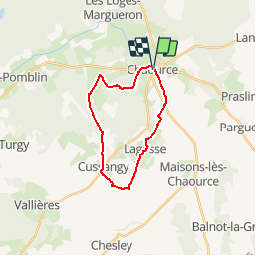
Randonnée Marche de 18,5 km à découvrir à Grand Est, Aube, Chaource. Cette randonnée est proposée par tracegps.

Description

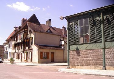
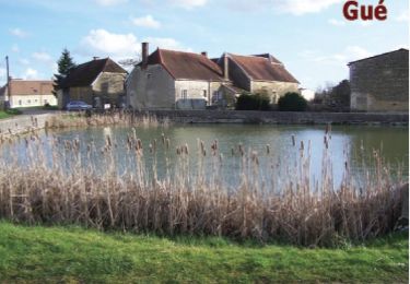
Circuit proposé par l’Office du Tourisme du Chaourçois en Pays d’Armance. Un circuit pour découvrir Chaource et ses trésors historiques et gastronomiques. Départ de l’Office du Tourisme de Chaource. Retrouvez ce circuit sur le site de l’Office du Tourisme du Chaourçois en Pays d’Armance. Ce circuit a été numérisé par les randonneurs du CODEPEM. Merci à Jean-Marie.

Profil altimétrique

Photos

Localisation

Pays :
France
Région :
Grand Est
Département/Province :
Aube
Commune :
Chaource
Localité :
Unknown
Départ:(Dec)
Départ:(UTM)
584758 ; 5323403 (31U) N.

Randonnées à proximité

Randonnée V.T.T. Chaource - Circuit des Forêts - Chaource - Photo
V.T.T.
tracegps

V.T.T.

Facile
Chaource, Grand Est, Aube, France
22 km | 25 km-effort
1h 45min
Oui
Randonnée Marche Cussangy - Circuit des petits gués - Cussangy - Photo
Marche
tracegps

Marche

Facile
Cussangy, Grand Est, Aube, France
5,1 km | 5,7 km-effort
1h 15min
Oui
Randonnée Vélo Chaource - Au pays du fromage de Chaource - Photo
Vélo
tracegps

Vélo

Moyen
Chaource, Grand Est, Aube, France
73 km | 86 km-effort
3h 0min
Oui
Randonnée V.T.T. Chaource - Chaource. Circuit des Forêts - Photo
V.T.T.
papadoc

V.T.T.

Facile
Chaource, Grand Est, Aube, France
21 km | 24 km-effort
1h 24min
Oui
Randonnée Marche Praslin - Praslin - Photo
Marche
randobe

Marche

Très difficile
Praslin, Grand Est, Aube, France
22 km | 26 km-effort
5h 51min
Oui
Randonnée V.T.T. Metz-Robert - metz maisons - Photo
V.T.T.
joeljoseph

V.T.T.

Difficile
Metz-Robert, Grand Est, Aube, France
42 km | 49 km-effort
2h 9min
Oui
Randonnée V.T.T. Chaource - chaource pargues 2 - Photo
V.T.T.
joeljoseph

V.T.T.

Très difficile
Chaource, Grand Est, Aube, France
49 km | 57 km-effort
2h 37min
Oui
Randonnée Marche Chaource - chaource - Photo
Marche
bougnaou

Marche

Facile
Chaource, Grand Est, Aube, France
10 km | 11,4 km-effort
2h 20min
Oui
Randonnée Marche Les Loges-Margueron - caisse epargne IK chevreuils - Photo
Marche
Patrick10300

Marche

Moyen
Les Loges-Margueron, Grand Est, Aube, France
6,8 km | 8,1 km-effort
1h 49min
Oui


Fermer
Mes abonnements