Randonnée Vélo Illiers-Combray - Sur la piste de Marcel Proust - Illiers-Combray - Photo

Sur la piste de Marcel Proust - Illiers-Combray

 tracegps
tracegps

Utilisateur

© OpenStreetMap contributors
Longueur
Longueur
14,8 km
Altitude max
Altitude max
175 m
Dénivelé positif
Dénivelé positif
91 m
Km-Effort
Km-Effort  
16 km
Altitude min
Altitude min
150 m
Dénivelé négatif
Dénivelé négatif
94 m
Boucle
Boucle
Oui
Date de création :
2014-12-10 00:00:00.0
Dernière modification :
2014-12-10 00:00:00.0

(0 Avis)

Vélo
Vélo
1h19
Difficulté : Facile

Scannez ce code QR pour ouvrir la randonnée dans l'application SityTrail

Application GPS de randonnée GRATUITE

Logo SityTrail SityTrail

IGN / Instituts géographiques

Télécharger SityTrail sur l'App Store Télécharger SityTrail sur Google Play

Logo SityTrail SityTrail World

Le monde est à vous

Télécharger SityTrail sur l'App Store Télécharger SityTrail sur Google Play Télécharger SityTrail sur Huawei AppGallery

À propos

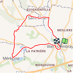
Randonnée Vélo de 14,8 km à découvrir à Centre-Val de Loire, Eure-et-Loir, Illiers-Combray. Cette randonnée est proposée par tracegps.

Description

Circuit proposé par Le Comité départemental de l’Eure-et-Loir. Départ de la place Maunoury à Illiers-Combray Un circuit thématisé qui relie les lieux emblématiques de l’œuvre de Marcel Prouts : la maison de Tante Léonie, le Pré Catelan, le château de Swann, les sources du Loir à Saint Eman, le village de Méréglise, le château de Villebon… Retrouvez le circuit et son descriptif sur le site du Comité départemental de l’Eure-et-Loir.

Profil altimétrique

Photos

Localisation

Pays :
France
Région :
Centre-Val de Loire
Département/Province :
Eure-et-Loir
Commune :
Illiers-Combray
Localité :
Unknown
Départ:(Dec)
Départ:(UTM)
369849 ; 5350984 (31U) N.

Randonnées à proximité

Randonnée Marche Illiers-Combray - Illiers-Combray promenade - Photo
Marche
benoit.baillot

Marche

Facile
(1)
Illiers-Combray, Centre-Val de Loire, Eure-et-Loir, France
3,1 km | 3,4 km-effort
46min
Oui
Randonnée sport Illiers-Combray - Randonnée Illiers, Combray - Photo
sport
ezola

sport

Très facile
Illiers-Combray, Centre-Val de Loire, Eure-et-Loir, France
7,8 km | 8,5 km-effort
Inconnu
Oui
Randonnée V.T.T. Illiers-Combray - 2022-04-30 - Photo
V.T.T.
Lucquiaud

V.T.T.

Très difficile
Illiers-Combray, Centre-Val de Loire, Eure-et-Loir, France
216 km | 255 km-effort
48h 33min
Non
Randonnée Marche Saint-Éman - St Eman 12.67 - Photo
Marche
togolo28

Marche

Facile
Saint-Éman, Centre-Val de Loire, Eure-et-Loir, France
12,7 km | 13,7 km-effort
3h 2min
Oui
Randonnée Marche Saint-Éman - St Eman 10.93 - Photo
Marche
togolo28

Marche

Facile
Saint-Éman, Centre-Val de Loire, Eure-et-Loir, France
10,9 km | 11,8 km-effort
2h 37min
Oui
Randonnée Marche Illiers-Combray - Illiers Combray 13.36 - Photo
Marche
togolo28

Marche

Facile
Illiers-Combray, Centre-Val de Loire, Eure-et-Loir, France
13,4 km | 14,7 km-effort
3h 15min
Oui
Randonnée Marche Illiers-Combray - Illiers Combray 11.23 - Photo
Marche
togolo28

Marche

Facile
Illiers-Combray, Centre-Val de Loire, Eure-et-Loir, France
11,2 km | 12,2 km-effort
2h 28min
Oui
Randonnée Marche Saint-Éman - St Eman 21.16 - Photo
Marche
togolo28

Marche

Moyen
Saint-Éman, Centre-Val de Loire, Eure-et-Loir, France
21 km | 23 km-effort
5h 5min
Oui
Randonnée Marche Saint-Éman - St Eman 19.43 - Photo
Marche
togolo28

Marche

Facile
Saint-Éman, Centre-Val de Loire, Eure-et-Loir, France
19,4 km | 21 km-effort
4h 40min
Oui


Fermer
Mes abonnements