Randonnée Cheval Authon-du-Perche - Les terres douces - Authon-du-Perche - Photo

Les terres douces - Authon-du-Perche

 tracegps
tracegps

Utilisateur

© OpenStreetMap contributors
Longueur
Longueur
22 km
Altitude max
Altitude max
260 m
Dénivelé positif
Dénivelé positif
261 m
Km-Effort
Km-Effort  
26 km
Altitude min
Altitude min
180 m
Dénivelé négatif
Dénivelé négatif
261 m
Boucle
Boucle
Oui
Date de création :
2014-12-10 00:00:00.0
Dernière modification :
2014-12-10 00:00:00.0

(1 Avis)

Cheval
Cheval
3h30
Difficulté : Difficile

Scannez ce code QR pour ouvrir la randonnée dans l'application SityTrail

Application GPS de randonnée GRATUITE

Logo SityTrail SityTrail

IGN / Instituts géographiques

Télécharger SityTrail sur l'App Store Télécharger SityTrail sur Google Play

Logo SityTrail SityTrail World

Le monde est à vous

Télécharger SityTrail sur l'App Store Télécharger SityTrail sur Google Play Télécharger SityTrail sur Huawei AppGallery

À propos

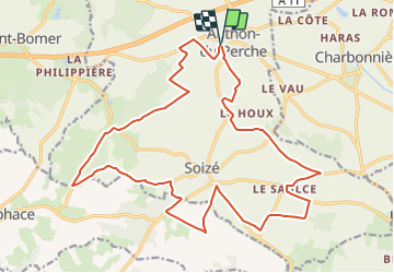
Randonnée Cheval de 22 km à découvrir à Centre-Val de Loire, Eure-et-Loir, Authon-du-Perche. Cette randonnée est proposée par tracegps.

Description

Circuit proposé par Le Comité départemental de l’Eure-et-Loir . Départ de la place des marronniers à Authon-du-Perche. La campagne des « Terres Douces » révèle un patrimoine plein de charme : l’ancien prieuré des Châtaigniers et le manoir de la Guillerie. Retrouvez le circuit et son descriptif sur le site du Comité départemental de l’Eure-et-Loir.

Profil altimétrique

Photos

Localisation

Pays :
France
Région :
Centre-Val de Loire
Département/Province :
Eure-et-Loir
Commune :
Authon-du-Perche
Localité :
Authon-du-Perche
Départ:(Dec)
Départ:(UTM)
343254 ; 5340124 (31U) N.

Commentaires

Veuillez vous connecter pour laisser un commentaire ou une note


authon du perche


Randonnées à proximité

Randonnée Marche Authon-du-Perche - Authon du Perche - Saint-Lubin-des-Cinq-Fonts 16 km - Photo
Marche
ODDAD78

Marche

Très difficile
Authon-du-Perche, Centre-Val de Loire, Eure-et-Loir, France
15,8 km | 19,3 km-effort
4h 23min
Oui
Randonnée Marche Les Étilleux - Les Etilleux 5.7 Km - Photo
Marche
ODDAD78

Marche

Très facile
Les Étilleux, Centre-Val de Loire, Eure-et-Loir, France
5,7 km | 7,3 km-effort
1h 33min
Oui
Randonnée Marche Béthonvilliers - Bethonvilliers 8,5 km - Photo
Marche
ODDAD78

Marche

Moyen
Béthonvilliers, Centre-Val de Loire, Eure-et-Loir, France
8,5 km | 10,2 km-effort
2h 19min
Oui
Randonnée Marche Authon-du-Perche - Authon-du-Perche et alentours 12 km - Photo
Marche
ODDAD78

Marche

Difficile
Authon-du-Perche, Centre-Val de Loire, Eure-et-Loir, France
11,6 km | 14,6 km-effort
3h 18min
Oui
Randonnée Marche Authon-du-Perche - Dernier entraînement Corse 2022 Hotton du perche - Photo
Marche
ezola

Marche

Très difficile
Authon-du-Perche, Centre-Val de Loire, Eure-et-Loir, France
26 km | 32 km-effort
6h 5min
Oui
Randonnée Marche Charbonnières - Charbonnières 17.18 - Photo
Marche
togolo28

Marche

Moyen
Charbonnières, Centre-Val de Loire, Eure-et-Loir, France
17,2 km | 19,7 km-effort
Inconnu
Oui
Randonnée Marche Authon-du-Perche - Authon du Perche 12.07 - Photo
Marche
togolo28

Marche

Facile
Authon-du-Perche, Centre-Val de Loire, Eure-et-Loir, France
12,1 km | 15 km-effort
Inconnu
Oui
Randonnée Voiture Authon-du-Perche - essai  - Photo
Voiture
Gaucho

Voiture

Très facile
Authon-du-Perche, Centre-Val de Loire, Eure-et-Loir, France
8,7 km | 10 km-effort
4min
Non
Randonnée Marche Coudray-au-Perche - Coudray au Perche 11.25 - Photo
Marche
togolo28

Marche

Facile
Coudray-au-Perche, Centre-Val de Loire, Eure-et-Loir, France
11,2 km | 14,1 km-effort
3h 2min
Oui


Fermer
Mes abonnements