Randonnée Marche Saint-Germain-de-Salles - Les écluses - Photo
 Gegetop
Gegetop

Utilisateur

© OpenStreetMap contributors
Longueur
Longueur
12,4 km
Altitude max
Altitude max
295 m
Dénivelé positif
Dénivelé positif
82 m
Km-Effort
Km-Effort  
13,5 km
Altitude min
Altitude min
270 m
Dénivelé négatif
Dénivelé négatif
82 m
Boucle
Boucle
Oui
Date de création :
2019-05-06 23:36:16.51
Dernière modification :
2019-05-06 23:36:16.51

(0 Avis)

Marche
Marche
2h57
Difficulté : Facile

Scannez ce code QR pour ouvrir la randonnée dans l'application SityTrail

Application GPS de randonnée GRATUITE

Logo SityTrail SityTrail

IGN / Instituts géographiques

Télécharger SityTrail sur l'App Store Télécharger SityTrail sur Google Play

Logo SityTrail SityTrail World

Le monde est à vous

Télécharger SityTrail sur l'App Store Télécharger SityTrail sur Google Play Télécharger SityTrail sur Huawei AppGallery

À propos

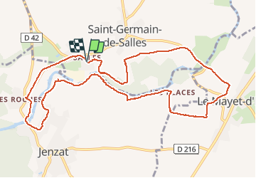
Randonnée Marche de 12,4 km à découvrir à Auvergne-Rhône-Alpes, Allier, Saint-Germain-de-Salles. Cette randonnée est proposée par Gegetop.

Description

En partie sur le PR13

Profil altimétrique

Photos

Localisation

Pays :
France
Région :
Auvergne-Rhône-Alpes
Département/Province :
Allier
Commune :
Saint-Germain-de-Salles
Localité :
Unknown
Départ:(Dec)
Départ:(UTM)
515779 ; 5113518 (31T) N.

Randonnées à proximité

Randonnée Marche Charroux - Moulin de Parrot - Photo
Marche
Vincent Bicard

Marche

Moyen
Charroux, Auvergne-Rhône-Alpes, Allier, France
14 km | 17,7 km-effort
3h 22min
Oui
Randonnée Marche Charroux - Le Moulin Parraud  - Photo
Marche
Gegetop

Marche

Facile
Charroux, Auvergne-Rhône-Alpes, Allier, France
13 km | 16,5 km-effort
3h 30min
Oui
Randonnée Marche Saint-Bonnet-de-Rochefort - les tressots - Photo
Marche
patrickboisard

Marche

Moyen
Saint-Bonnet-de-Rochefort, Auvergne-Rhône-Alpes, Allier, France
6,6 km | 8,6 km-effort
1h 37min
Oui
Randonnée Marche Charroux - Randonnée à Charroux, Vichy, 2023 - Photo
Marche
ezola

Marche

Difficile
Charroux, Auvergne-Rhône-Alpes, Allier, France
13,2 km | 16,7 km-effort
3h 22min
Non
Randonnée V.T.T. Broût-Vernet - top - Photo
V.T.T.
ricodal

V.T.T.

Très facile
Broût-Vernet, Auvergne-Rhône-Alpes, Allier, France
34 km | 44 km-effort
3h 3min
Non
Randonnée Marche Charroux - GR de Pays Val de Sioule - Photo
Marche
loursblanc

Marche

Facile
Charroux, Auvergne-Rhône-Alpes, Allier, France
77 km | 100 km-effort
20h 0min
Oui
Randonnée Marche Charroux - GR de Pays Val de Sioule - Photo
Marche
loursblanc

Marche

Facile
Charroux, Auvergne-Rhône-Alpes, Allier, France
77 km | 100 km-effort
20h 0min
Oui
Randonnée Autre activité Charroux - charroux  - Photo
Autre activité
kronio

Autre activité

Facile
Charroux, Auvergne-Rhône-Alpes, Allier, France
9,1 km | 13 km-effort
3h 21min
Oui
Randonnée Marche Charroux - charroux 2 em marche  - Photo
Marche
jjf

Marche

Très facile
Charroux, Auvergne-Rhône-Alpes, Allier, France
5,9 km | 7,4 km-effort
1h 9min
Oui


Fermer
Mes abonnements