


30.03.2019 - LA GACILLY ouest et est

babeth35
Utilisateur
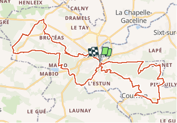

Longueur
30 km

Altitude max
100 m

Dénivelé positif
540 m
Km-Effort
37 km

Altitude min
3 m

Dénivelé négatif
546 m
Boucle
Oui
Date de création :
2019-04-01 08:53:58.531
Dernière modification :
2020-07-20 14:58:44.151
7h15
Difficulté : Moyen

Application GPS de randonnée GRATUITE
 SityTrail
IGN / Instituts géographiques
SityTrail Plus
Le monde est à vous
À propos
Randonnée Marche de 30 km à découvrir à Bretagne, Morbihan, La Gacilly. Cette randonnée est proposée par babeth35.
Photos


Localisation
Pays :
France
Région :
Bretagne
Département/Province :
Morbihan
Commune :
La Gacilly
Localité :
La Gacilly
Départ:(Dec)
Départ:(UTM)
565260 ; 5290195 (30T) N.
Commentaires