


FFSA 2019 Championnat BC

norbertmarteau
Utilisateur
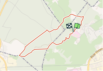

Longueur
4 km

Altitude max
331 m

Dénivelé positif
74 m
Km-Effort
5 km

Altitude min
271 m

Dénivelé négatif
74 m
Boucle
Oui
Date de création :
2019-05-07 00:59:07.422
Dernière modification :
2019-05-07 00:59:07.422
19m
Difficulté : Facile

Application GPS de randonnée GRATUITE
 SityTrail
IGN / Instituts géographiques
SityTrail Plus
Le monde est à vous
À propos
Randonnée V.T.T. de 4 km à découvrir à Bourgogne-Franche-Comté, Doubs, Besançon. Cette randonnée est proposée par norbertmarteau.
Localisation
Pays :
France
Région :
Bourgogne-Franche-Comté
Département/Province :
Doubs
Commune :
Besançon
Localité :
Unknown
Départ:(Dec)
Départ:(UTM)
724133 ; 5235546 (31T) N.
Commentaires