Randonnée Marche Deux-Verges - Puy de la Tuile - Photo
 patrando49
patrando49

Utilisateur

© OpenStreetMap contributors
Longueur
Longueur
8,9 km
Altitude max
Altitude max
1289 m
Dénivelé positif
Dénivelé positif
295 m
Km-Effort
Km-Effort  
12,8 km
Altitude min
Altitude min
1024 m
Dénivelé négatif
Dénivelé négatif
289 m
Boucle
Boucle
Non
Date de création :
2014-12-10 00:00:00.0
Dernière modification :
2014-12-10 00:00:00.0

(1 Avis)

Marche
Marche
2h44
Difficulté : Facile

Scannez ce code QR pour ouvrir la randonnée dans l'application SityTrail

Application GPS de randonnée GRATUITE

Logo SityTrail SityTrail

IGN / Instituts géographiques

Télécharger SityTrail sur l'App Store Télécharger SityTrail sur Google Play

Logo SityTrail SityTrail World

Le monde est à vous

Télécharger SityTrail sur l'App Store Télécharger SityTrail sur Google Play Télécharger SityTrail sur Huawei AppGallery

À propos

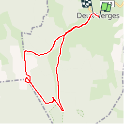
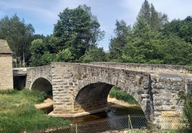
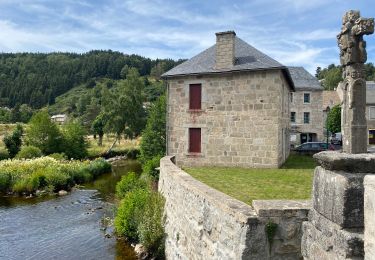
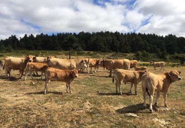
Randonnée Marche de 8,9 km à découvrir à Auvergne-Rhône-Alpes, Cantal, Deux-Verges. Cette randonnée est proposée par patrando49.

Profil altimétrique

Localisation

Pays :
France
Région :
Auvergne-Rhône-Alpes
Département/Province :
Cantal
Commune :
Deux-Verges
Localité :
Unknown
Départ:(Dec)
Départ:(UTM)
501921 ; 4961402 (31T) N.

Commentaires

Veuillez vous connecter pour laisser un commentaire ou une note


simple et tranquille


Randonnées à proximité

Randonnée A pied Chauchailles - le sentier des Espagnols  - Photo
A pied
audier

A pied

Difficile
(1)
Chauchailles, Occitanie, Lozère, France
22 km | 31 km-effort
7h 7min
Oui
Randonnée Marche Chauchailles - sentier des espagnols  - Photo
Marche
GUIDE
nadinebondoux

Marche

Difficile
Chauchailles, Occitanie, Lozère, France
22 km | 32 km-effort
6h 48min
Oui
Randonnée Marche Chauchailles - Gorges du Bèz sentier des espagnols - Photo
Marche
GUIDE
Roger Philippe Wallez

Marche

Très difficile
Chauchailles, Occitanie, Lozère, France
22 km | 31 km-effort
7h 34min
Oui
Randonnée Marche Brion - La chaldette  - Photo
Marche
GUIDE
antignacs

Marche

Moyen
Brion, Occitanie, Lozère, France
19,9 km | 26 km-effort
5h 22min
Oui
Randonnée Marche Chaudes-Aigues - Chemin de la mine  - Photo
Marche
nicolasdresse

Marche

(1)
Chaudes-Aigues, Auvergne-Rhône-Alpes, Cantal, France
4,3 km | 6,1 km-effort
2h 11min
Oui
Randonnée Marche Brion - LA CHALDETTE 48 - Le Fau - Le Truc du Cheylaret - Reyrac - Photo
Marche
jeff66

Marche

Moyen
(1)
Brion, Occitanie, Lozère, France
10,5 km | 13,9 km-effort
2h 44min
Oui
Randonnée Marche Brion - De La Chaldette à Fournels - Photo
Marche
tracegps

Marche

Difficile
Brion, Occitanie, Lozère, France
14,8 km | 19,6 km-effort
3h 16min
Non
Randonnée Marche Chauchailles - Les Gorges du Bes - Photo
Marche
tracegps

Marche

Difficile
(1)
Chauchailles, Occitanie, Lozère, France
21 km | 30 km-effort
7h 0min
Oui
Randonnée Marche Brion - chaldette termes - Photo
Marche
randodyssée

Marche

Moyen
Brion, Occitanie, Lozère, France
22 km | 30 km-effort
7h 23min
Non


Fermer
Mes abonnements