Randonnée Marche Courmayeur - courmayeur bertone bonatti - Photo

courmayeur bertone bonatti

 lebail.frederic
lebail.frederic

Utilisateur

© OpenStreetMap contributors
Longueur
Longueur
11,9 km
Altitude max
Altitude max
2034 m
Dénivelé positif
Dénivelé positif
1093 m
Km-Effort
Km-Effort  
24 km
Altitude min
Altitude min
1203 m
Dénivelé négatif
Dénivelé négatif
273 m
Boucle
Boucle
Non
Date de création :
2014-12-10 00:00:00.0
Dernière modification :
2014-12-10 00:00:00.0

(0 Avis)

Marche
Marche
--
Difficulté : Moyen

Scannez ce code QR pour ouvrir la randonnée dans l'application SityTrail

Application GPS de randonnée GRATUITE

Logo SityTrail SityTrail

IGN / Instituts géographiques

Télécharger SityTrail sur l'App Store Télécharger SityTrail sur Google Play

Logo SityTrail SityTrail World

Le monde est à vous

Télécharger SityTrail sur l'App Store Télécharger SityTrail sur Google Play Télécharger SityTrail sur Huawei AppGallery

À propos

Randonnée Marche de 11,9 km à découvrir à Vallée d'Aoste, Inconnu, Courmayeur. Cette randonnée est proposée par lebail.frederic.

Description

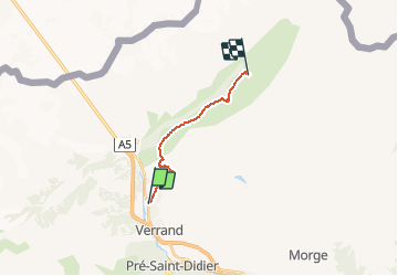
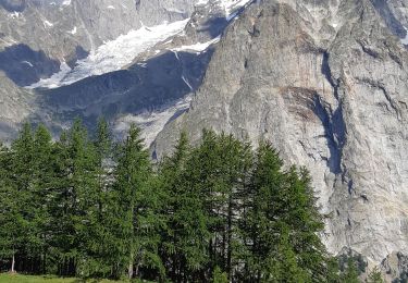
Etapa del Tour del Mont Blanc, entre la localidad de Courmayeur y el Refugio Walter Bonatti (Alpes, Italia).

Desde Courmayeur ascendemos al Refugio G. Bertone, continuamos a media ladera, y tras pasar por Arpe Leche y Arpe Secheron, llegamos al Refugio W. Bonatti.

*** Datos Ruta ***
Ruta: Courmayeur (1.210 mts) – Ref. Bertone (1.989 mts) – Ref. Bonatti (2.022 mts)
Distancia: 5’6 kmts – 7’8 kmts = 13’4 kmts
Desnivel Ascendido: 780 mts - 315 mts = 1.095 mts
Desnivel Descendido: 0 mts - 285 mts = 285 mts
Tiempo (sin paradas): 2h – 3h = 5h

Profil altimétrique

Points d'intérêt

Point d'intérêt Courmayeur - Arpe Leche - Photo
lebail.frederic
COURMAYEUR 
Point d'intérêt Courmayeur - Arpe Secheron - Photo
lebail.frederic
COURMAYEUR 
Point d'intérêt Courmayeur - Courmayeur - Photo
lebail.frederic
COURMAYEUR 
Point d'intérêt Courmayeur - Ref Bertone - Photo
lebail.frederic
COURMAYEUR 
Point d'intérêt Courmayeur - Ref Bonatti - Photo
lebail.frederic
COURMAYEUR 

Localisation

Pays :
Italie
Région :
Vallée d'Aoste
Département/Province :
Inconnu
Commune :
Courmayeur
Localité :
Unknown
Départ:(Dec)
Départ:(UTM)
342257 ; 5072829 (32T) N.

Randonnées à proximité

Randonnée A pied Courmayeur - Alta Via n. 2 della Valle d'Aosta - Tappa 1 - Photo
A pied
PRO

A pied

Difficile
Courmayeur, Vallée d'Aoste, Inconnu, Italie
15,2 km | 32 km-effort
7h 15min
Non
Randonnée A pied Courmayeur - (SI F08) Courmayeur - Rifugio Bonatti - Photo
A pied
PRO

A pied

Moyen
Courmayeur, Vallée d'Aoste, Inconnu, Italie
11,9 km | 24 km-effort
5h 22min
Non
Randonnée Marche Morgex - arpy . lac d arpy . arpy 2h50 - Photo
Marche
stef789

Marche

Très facile
Morgex, Vallée d'Aoste, Inconnu, Italie
10,3 km | 16,1 km-effort
3h 36min
Oui
Randonnée Marche Courmayeur - étape monte Bianco mottets - Photo
Marche
Bernadette Noirant

Marche

Difficile
Courmayeur, Vallée d'Aoste, Inconnu, Italie
21 km | 38 km-effort
8h 17min
Non
Randonnée Marche Courmayeur - TMB J5 Ref. BIANCO - LES MOTTETS - Photo
Marche
GerardBouche

Marche

Difficile
Courmayeur, Vallée d'Aoste, Inconnu, Italie
20 km | 38 km-effort
7h 49min
Non
Randonnée Marche Courmayeur - TMB - Etape 5 - Photo
Marche
maxime.ranchin@aliceadsl.fr

Marche

Difficile
(1)
Courmayeur, Vallée d'Aoste, Inconnu, Italie
16,5 km | 34 km-effort
6h 47min
Non
Randonnée Marche Courmayeur - TMB 05 - Courmayeur -> Arnouva (chalet du Val Ferret) - Photo
Marche
uru2010

Marche

Difficile
Courmayeur, Vallée d'Aoste, Inconnu, Italie
17,6 km | 32 km-effort
6h 59min
Non
Randonnée Marche Morgex - Lac d'Arpy et le lac Di Pietra Rossa... - Photo
Marche
Alfredy

Marche

Très difficile
Morgex, Vallée d'Aoste, Inconnu, Italie
15,3 km | 28 km-effort
5h 37min
Oui
Randonnée Marche Morgex - Lac d'Arpy - Photo
Marche
Alfredy

Marche

Difficile
(1)
Morgex, Vallée d'Aoste, Inconnu, Italie
10,3 km | 15,9 km-effort
3h 17min
Oui


Fermer
Mes abonnements