


fort dosner

fbienmuller
Utilisateur
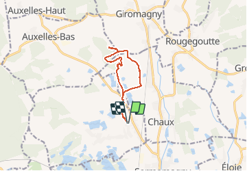

Longueur
9,6 km

Altitude max
548 m

Dénivelé positif
157 m
Km-Effort
11,7 km

Altitude min
408 m

Dénivelé négatif
156 m
Boucle
Oui
Date de création :
2014-12-10 00:00:00.0
Dernière modification :
2014-12-10 00:00:00.0
2h11
Difficulté : Facile

Application GPS de randonnée GRATUITE
 SityTrail
IGN / Instituts géographiques
SityTrail Plus
Le monde est à vous
À propos
Randonnée Marche de 9,6 km à découvrir à Bourgogne-Franche-Comté, Territoire-de-Belfort, Lachapelle-sous-Chaux. Cette randonnée est proposée par fbienmuller.
Description
balade
Localisation
Pays :
France
Région :
Bourgogne-Franche-Comté
Département/Province :
Territoire-de-Belfort
Commune :
Lachapelle-sous-Chaux
Localité :
Unknown
Départ:(Dec)
Départ:(UTM)
336481 ; 5285781 (32T) N.
Commentaires