Randonnée Marche Gurcy-le-Châtel - SLV-130112 - (AMAJ) Chalautre-Gurcy - Photo

SLV-130112 - (AMAJ) Chalautre-Gurcy

 randodan
randodan

Utilisateur

© OpenStreetMap contributors
Longueur
Longueur
15,6 km
Altitude max
Altitude max
145 m
Dénivelé positif
Dénivelé positif
250 m
Km-Effort
Km-Effort  
18,9 km
Altitude min
Altitude min
74 m
Dénivelé négatif
Dénivelé négatif
252 m
Boucle
Boucle
Oui
Date de création :
2014-12-10 00:00:00.0
Dernière modification :
2014-12-10 00:00:00.0

(1 Avis)

Marche
Marche
4h09
Difficulté : Inconnu

Scannez ce code QR pour ouvrir la randonnée dans l'application SityTrail

Application GPS de randonnée GRATUITE

Logo SityTrail SityTrail

IGN / Instituts géographiques

Télécharger SityTrail sur l'App Store Télécharger SityTrail sur Google Play

Logo SityTrail SityTrail World

Le monde est à vous

Télécharger SityTrail sur l'App Store Télécharger SityTrail sur Google Play Télécharger SityTrail sur Huawei AppGallery

À propos

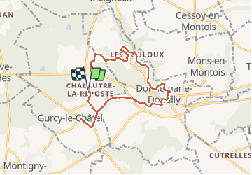
Randonnée Marche de 15,6 km à découvrir à Île-de-France, Seine-et-Marne, Gurcy-le-Châtel. Cette randonnée est proposée par randodan.

Profil altimétrique

Localisation

Pays :
France
Région :
Île-de-France
Département/Province :
Seine-et-Marne
Commune :
Gurcy-le-Châtel
Localité :
Unknown
Départ:(Dec)
Départ:(UTM)
506786 ; 5369744 (31U) N.

Commentaires

Veuillez vous connecter pour laisser un commentaire ou une note


Gucy-Le-Châtel (77)


Randonnées à proximité

Randonnée A pied Donnemarie-Dontilly - Montereau - Donnemarie Dontilly Linéaire 30 km - Photo
A pied
chessyca

A pied

Difficile
Donnemarie-Dontilly, Île-de-France, Seine-et-Marne, France
31 km | 38 km-effort
8h 31min
Non
Randonnée Marche Montigny-Lencoup - Boucle Montigny Lencoup - Donnemarie 30 km - Photo
Marche
chessyca

Marche

Très difficile
Montigny-Lencoup, Île-de-France, Seine-et-Marne, France
30 km | 35 km-effort
6h 6min
Oui
Randonnée Marche Donnemarie-Dontilly - Boucle autour de Donnemarie Dontilly  - Photo
Marche
BrunoMounier

Marche

Difficile
Donnemarie-Dontilly, Île-de-France, Seine-et-Marne, France
11,4 km | 14,1 km-effort
2h 9min
Oui
Randonnée Marche Montigny-Lencoup - Boucle Montigny Lencoup - Donnemarie - Dontilly - Preuilly  - Photo
Marche
chessyca

Marche

Facile
Montigny-Lencoup, Île-de-France, Seine-et-Marne, France
33 km | 39 km-effort
6h 34min
Oui
Randonnée Marche Montigny-Lencoup - Boucle Montigny Lencoup - Donnemarie - Sigy  - Photo
Marche
chessyca

Marche

Moyen
Montigny-Lencoup, Île-de-France, Seine-et-Marne, France
32 km | 38 km-effort
5h 59min
Non
Randonnée Marche Mons-en-Montois - Mons en montois 77 - Photo
Marche
raypat

Marche

Très facile
Mons-en-Montois, Île-de-France, Seine-et-Marne, France
21 km | 25 km-effort
5h 14min
Oui
Randonnée Marche Donnemarie-Dontilly - DD4-9-2013 - Photo
Marche
Gessay

Marche

Très facile
Donnemarie-Dontilly, Île-de-France, Seine-et-Marne, France
4,9 km | 6,2 km-effort
1h 5min
Oui
Randonnée Marche Gurcy-le-Châtel - 2013-01-12_chalautre - Photo
Marche
jcm17

Marche

Facile
(1)
Gurcy-le-Châtel, Île-de-France, Seine-et-Marne, France
14,3 km | 17,5 km-effort
3h 48min
Oui
Randonnée Marche Donnemarie-Dontilly - Donemarie  - Photo
Marche
Gessay

Marche

Très facile
Donnemarie-Dontilly, Île-de-France, Seine-et-Marne, France
5,4 km | 6,6 km-effort
1h 33min
Oui


Fermer
Mes abonnements