Randonnée Marche Grandfontaine - Le Donon en raquettes - Grandfontaine - Photo

Le Donon en raquettes - Grandfontaine

 tracegps
tracegps

Utilisateur

© OpenStreetMap contributors
Longueur
Longueur
5,9 km
Altitude max
Altitude max
996 m
Dénivelé positif
Dénivelé positif
299 m
Km-Effort
Km-Effort  
9,8 km
Altitude min
Altitude min
731 m
Dénivelé négatif
Dénivelé négatif
298 m
Boucle
Boucle
Oui
Date de création :
2014-12-10 00:00:00.0
Dernière modification :
2014-12-10 00:00:00.0

(0 Avis)

Marche
Marche
2h00
Difficulté : Moyen

Scannez ce code QR pour ouvrir la randonnée dans l'application SityTrail

Application GPS de randonnée GRATUITE

Logo SityTrail SityTrail

IGN / Instituts géographiques

Télécharger SityTrail sur l'App Store Télécharger SityTrail sur Google Play

Logo SityTrail SityTrail World

Le monde est à vous

Télécharger SityTrail sur l'App Store Télécharger SityTrail sur Google Play Télécharger SityTrail sur Huawei AppGallery

À propos

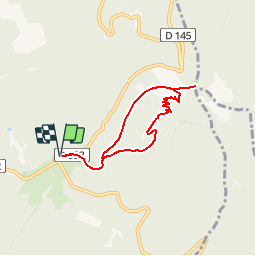
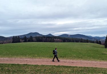
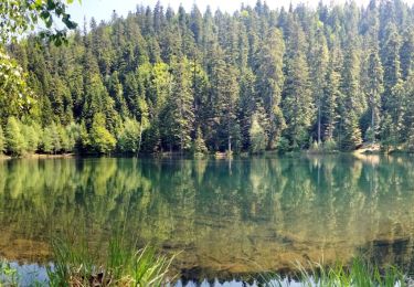
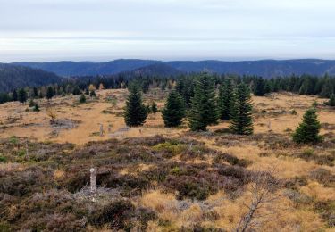
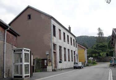
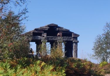
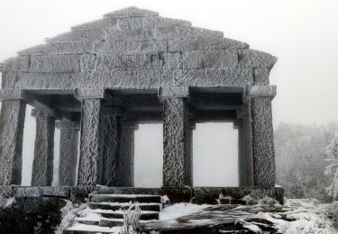
Randonnée Marche de 5,9 km à découvrir à Grand Est, Bas-Rhin, Grandfontaine. Cette randonnée est proposée par tracegps.

Description

Départ du col du Donon, montée en direction de la plate forme du Donon vers le Temple du Donon. Descente vers le col entre les deux Donons et retour par la face Ouest en direction de la maison forestière.

Profil altimétrique

Photos

Localisation

Pays :
France
Région :
Grand Est
Département/Province :
Bas-Rhin
Commune :
Grandfontaine
Localité :
Unknown
Départ:(Dec)
Départ:(UTM)
363144 ; 5374412 (32U) N.

Randonnées à proximité

Randonnée Marche Grandfontaine - Donon sentier des casemates - sud - Photo
Marche
VacheKiri67

Marche

Moyen
(1)
Grandfontaine, Grand Est, Bas-Rhin, France
12,6 km | 16,9 km-effort
4h 13min
Oui
Randonnée Marche Grandfontaine - Le site des 2 Donons - Photo
Marche
VacheKiri67

Marche

Moyen
(4)
Grandfontaine, Grand Est, Bas-Rhin, France
12,6 km | 19,4 km-effort
4h 52min
Oui
Randonnée Marche Moussey - Col de Prayé - Photo
Marche
VacheKiri67

Marche

Difficile
(1)
Moussey, Grand Est, Vosges, France
16,8 km | 23 km-effort
6h 55min
Oui
Randonnée Marche La Broque - 2024-03-17 Marche Ferme Auberge du Bambois - Photo
Marche
GUIDE
holtzv

Marche

Facile
La Broque, Grand Est, Bas-Rhin, France
23 km | 35 km-effort
7h 55min
Oui
Randonnée Marche Grandfontaine - 2023-05-29 Marche Les Minières Lac de la Maix - Photo
Marche
GUIDE
holtzv

Marche

Moyen
Grandfontaine, Grand Est, Bas-Rhin, France
22 km | 34 km-effort
7h 43min
Oui
Randonnée Marche Grandfontaine - 2022-11-12 Marche Grandfontaine Tête Mathis Col de Praye La Corbeille - Photo
Marche
GUIDE
holtzv

Marche

Moyen
Grandfontaine, Grand Est, Bas-Rhin, France
15,3 km | 23 km-effort
4h 34min
Oui
Randonnée A pied Grandfontaine - Circuit du Chemin d'Allemagne - Photo
A pied
PRO

A pied

Facile
Grandfontaine, Grand Est, Bas-Rhin, France
8,7 km | 13,9 km-effort
3h 10min
Non
Randonnée Marche Grandfontaine - 2020-09-20 Marche Donon Petit Donon Casemates - Photo
Marche
GUIDE
holtzv

Marche

Très facile
(1)
Grandfontaine, Grand Est, Bas-Rhin, France
13,4 km | 20 km-effort
4h 17min
Oui
Randonnée Marche Grandfontaine - 2019-01-05 Marche Temple du Donon - Photo
Marche
GUIDE
holtzv

Marche

Moyen
Grandfontaine, Grand Est, Bas-Rhin, France
5,6 km | 9,3 km-effort
1h 54min
Oui


Fermer
Mes abonnements