Randonnée Marche Trets - Sentier des vignes Trets - Photo
 Elidabeth
Elidabeth

Utilisateur

© OpenStreetMap contributors
Longueur
Longueur
13,2 km
Altitude max
Altitude max
422 m
Dénivelé positif
Dénivelé positif
280 m
Km-Effort
Km-Effort  
16,9 km
Altitude min
Altitude min
241 m
Dénivelé négatif
Dénivelé négatif
279 m
Boucle
Boucle
Oui
Date de création :
2014-12-10 00:00:00.0
Dernière modification :
2014-12-10 00:00:00.0

(1 Avis)

Marche
Marche
2h55
Difficulté : Moyen

Scannez ce code QR pour ouvrir la randonnée dans l'application SityTrail

Application GPS de randonnée GRATUITE

Logo SityTrail SityTrail

IGN / Instituts géographiques

Télécharger SityTrail sur l'App Store Télécharger SityTrail sur Google Play

Logo SityTrail SityTrail World

Le monde est à vous

Télécharger SityTrail sur l'App Store Télécharger SityTrail sur Google Play Télécharger SityTrail sur Huawei AppGallery

À propos

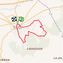
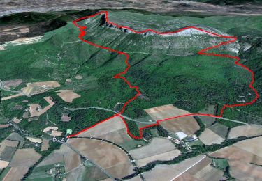
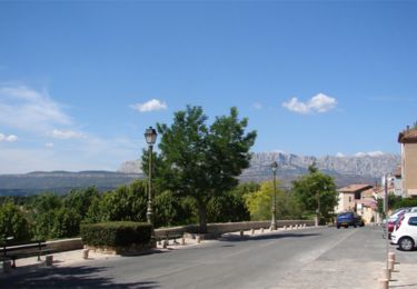
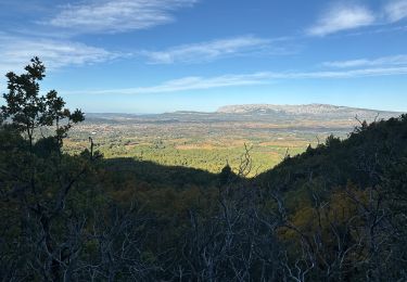
Randonnée Marche de 13,2 km à découvrir à Provence-Alpes-Côte d'Azur, Bouches-du-Rhône, Trets. Cette randonnée est proposée par Elidabeth.

Profil altimétrique

Localisation

Pays :
France
Région :
Provence-Alpes-Côte d'Azur
Département/Province :
Bouches-du-Rhône
Commune :
Trets
Localité :
Unknown
Départ:(Dec)
Départ:(UTM)
717329 ; 4814223 (31T) N.

Commentaires

Veuillez vous connecter pour laisser un commentaire ou une note


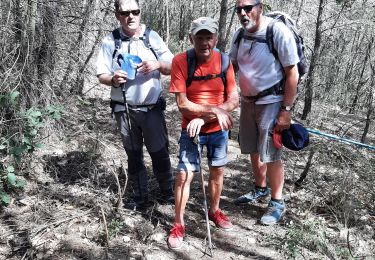
Très belle rando, aller à ot de trets il vous donneront la carte et le descriptif de la randonnée il y a un itinéraire bis pour éviter le goudron au départ de trets rando à faire


Randonnées à proximité

Randonnée V.T.T. Trets - les contreforts du mont Olympe - Photo
V.T.T.
GUIDE
amiral13

V.T.T.

Facile
(1)
Trets, Provence-Alpes-Côte d'Azur, Bouches-du-Rhône, France
11,8 km | 15,5 km-effort
2h 52min
Oui
Randonnée Marche Pourrières - Mont Aurélien  - Photo
Marche
GUIDE
affinetataille

Marche

Moyen
(1)
Pourrières, Provence-Alpes-Côte d'Azur, Var, France
17,3 km | 27 km-effort
7h 0min
Oui
Randonnée Marche Peynier - De Peynier aux ruines de Dalbessy - Photo
Marche
ARPF

Marche

Moyen
(1)
Peynier, Provence-Alpes-Côte d'Azur, Bouches-du-Rhône, France
8 km | 10,6 km-effort
2h 16min
Oui
Randonnée Marche Peynier - De Peynier aux ruines de Dalbessy - Photo
Marche
tracegps

Marche

Moyen
(2)
Peynier, Provence-Alpes-Côte d'Azur, Bouches-du-Rhône, France
8 km | 10,6 km-effort
2h 0min
Oui
Randonnée Marche Pourrières - Mt Olympe et le pas du Titet - Photo
Marche
ETMU5496

Marche

Difficile
Pourrières, Provence-Alpes-Côte d'Azur, Var, France
19,9 km | 32 km-effort
7h 15min
Oui
Randonnée Marche Trets - Mont Olympe - Rocher de Onze heures - Photo
Marche
frizou83

Marche

Très difficile
(1)
Trets, Provence-Alpes-Côte d'Azur, Bouches-du-Rhône, France
13 km | 21 km-effort
4h 44min
Oui
Randonnée Marche Pourrières - Pourcieux :Mont Olympe et Pas du Titet - Photo
Marche
ETMU5496

Marche

Très difficile
(1)
Pourrières, Provence-Alpes-Côte d'Azur, Var, France
20 km | 32 km-effort
7h 22min
Non
Randonnée Marche Trets - Kirbon 2 juin 2022 - Photo
Marche
patzierk

Marche

Difficile
Trets, Provence-Alpes-Côte d'Azur, Bouches-du-Rhône, France
11 km | 16,7 km-effort
7h 41min
Oui
Randonnée Marche Trets - Kirbon  - Photo
Marche
gaggiroland

Marche

Moyen
Trets, Provence-Alpes-Côte d'Azur, Bouches-du-Rhône, France
10,6 km | 14,9 km-effort
3h 30min
Non


Fermer
Mes abonnements