


Cabane de Susanfe

pnoth
Utilisateur
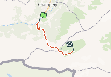

Longueur
6,5 km

Altitude max
2090 m

Dénivelé positif
1092 m
Km-Effort
17,6 km

Altitude min
1070 m

Dénivelé négatif
73 m
Boucle
Non
Date de création :
2014-12-11 00:00:00.0
Dernière modification :
2014-12-11 00:00:00.0
--
Difficulté : Inconnu

Application GPS de randonnée GRATUITE
 SityTrail
IGN / Instituts géographiques
SityTrail Plus
Le monde est à vous
À propos
Randonnée Autre activité de 6,5 km à découvrir à Valais, Monthey, Champéry. Cette randonnée est proposée par pnoth.
Description
English: http://www.noth.ch/h0114_e.html
Français: http://www.noth.ch/h0114_f.html
Deutsch: http://www.noth.ch/h0114_d.html
Localisation
Pays :
Suisse
Région :
Valais
Département/Province :
Monthey
Commune :
Champéry
Localité :
Unknown
Départ:(Dec)
Départ:(UTM)
334744 ; 5114254 (32T) N.
Commentaires