![](/images/other/stat-length.png)
![Randonnée Marche Echternach - mullerthal trail 1 - Photo](https://media.geolcdn.com/t/1900/400/ext.pjpeg?maxdim=2&url=https%3A%2F%2Fstatic1.geolcdn.com%2Fsiteimages%2Fupload%2Ffiles%2F1553511878bg_sport_marche.png)
mullerthal trail 1
flip96
Utilisateur
![Longueur](/images/other/stat-length.png)
Longueur
44 km
![Altitude max](https://static1.geolcdn.com/siteimages/upload/files/1508320355ic_sort_altitude_max_24dp.png)
Altitude max
406 m
![Dénivelé positif](https://static1.geolcdn.com/siteimages/upload/files/1508320355ic_sort_den_pos_24dp.png)
Dénivelé positif
1046 m
![Km-Effort](/images/other/stat-length.png)
Km-Effort
58 km
![Altitude min](https://static1.geolcdn.com/siteimages/upload/files/1508320355ic_sort_altitude_min_24dp.png)
Altitude min
156 m
![Dénivelé négatif](https://static1.geolcdn.com/siteimages/upload/files/1508320355ic_sort_den_neg_24dp.png)
Dénivelé négatif
1046 m
![Boucle](https://static1.geolcdn.com/siteimages/upload/files/16400158638029165_repeat_loop_refresh_sync_direction_icon.png)
Boucle
Oui
Date de création :
2014-12-10 00:00:00.0
Dernière modification :
2014-12-10 00:00:00.0
![Marche](https://static1.geolcdn.com/sitytour/trail-icons/101.png)
7h20
Difficulté : Difficile
![Scannez ce code QR pour ouvrir la randonnée dans l'application SityTrail](https://capi.geolives.com/qq0zvz2zws4bq2lad0pu/sitytour/trails/186726/qr.png?size=200)
Application GPS de randonnée GRATUITE
À propos
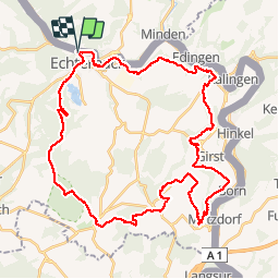
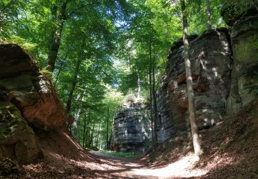
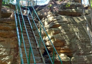
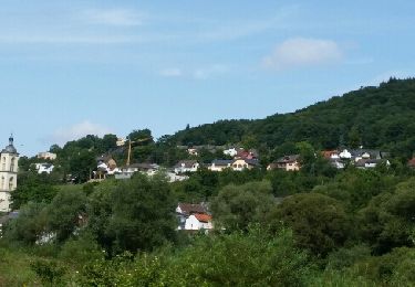
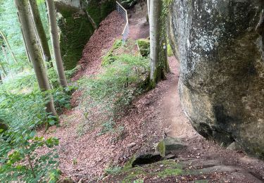
Randonnée Marche de 44 km à découvrir à Inconnu, Canton Echternach, Echternach. Cette randonnée est proposée par flip96.
Description
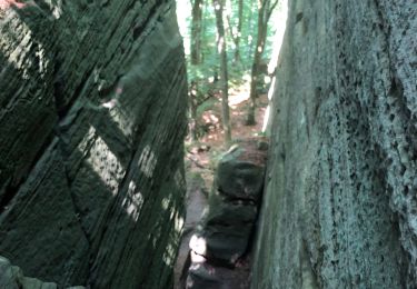
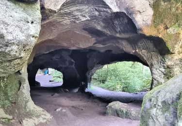
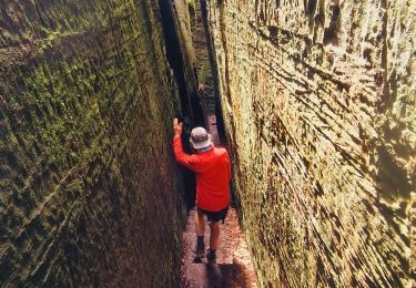
Müllerthal Trail 1: 44km. start vanaf busstation Rue de la Gare Echternach. Gratis parkeren!
Route is duidelijk aangegeven met rode M, alleen eerste km. veel zoeken.
Opmerkingen? flip96@home.nl
Localisation
Pays :
Luxembourg
Région :
Inconnu
Département/Province :
Canton Echternach
Commune :
Echternach
Localité :
Unknown
Départ:(Dec)
Départ:(UTM)
314100 ; 5521388 (32U) N.
Commentaires
Randonnées à proximité
![Randonnée Marche Berdorf - Berdorf - B2 - Müllerthal - Photo](https://media.geolcdn.com/t/375/260/ext.jpg?maxdim=2&url=https%3A%2F%2Fmedia.geolcdn.com%2Ff%2F517daf86-eb8b-412e-9a7e-d0a346807e81.jpg)
![Marche Marche](https://static1.geolcdn.com/sitytour/trail-icons/101.png)
Berdorf - B2 - Müllerthal
Marche
Moyen
(1)
Berdorf,
Inconnu,
Canton Echternach,
Luxembourg
![](/images/other/stat-length.png)
6,7 km | 8,5 km-effort
1h 35min
![](https://static1.geolcdn.com/siteimages/upload/files/16400158638029165_repeat_loop_refresh_sync_direction_icon.png)
Oui
![Randonnée Marche Berdorf - Berdorf - B8 - Müllerthal - Photo](https://media.geolcdn.com/t/375/260/ext.jpg?maxdim=2&url=https%3A%2F%2Fmedia.geolcdn.com%2Ff%2F7a8870ac-d558-4a39-b7c2-bdeb26e936c0.jpg)
![Marche Marche](https://static1.geolcdn.com/sitytour/trail-icons/101.png)
Berdorf - B8 - Müllerthal
Marche
Moyen
(1)
Berdorf,
Inconnu,
Canton Echternach,
Luxembourg
![](/images/other/stat-length.png)
11,7 km | 15 km-effort
3h 24min
![](https://static1.geolcdn.com/siteimages/upload/files/16400158638029165_repeat_loop_refresh_sync_direction_icon.png)
Oui
![Randonnée Marche Berdorf - MÜLLERTHAL (Bollendorf-Pont) - Photo](https://media.geolcdn.com/t/375/260/ext.jpg?maxdim=2&url=https%3A%2F%2Fservices.sitytrail.com%2FGeolivesWS%2FDownloadMedia.ashx%3FTrailID%3D816349%26Media%3Dfix__20170824131142.jpg)
![Marche Marche](https://static1.geolcdn.com/sitytour/trail-icons/101.png)
MÜLLERTHAL (Bollendorf-Pont)
Marche
Facile
(1)
Berdorf,
Inconnu,
Canton Echternach,
Luxembourg
![](/images/other/stat-length.png)
10,5 km | 14,3 km-effort
3h 10min
![](https://static1.geolcdn.com/siteimages/upload/files/16400158638029165_repeat_loop_refresh_sync_direction_icon.png)
Oui
![Randonnée Marche Ernzen - DeLux Wanderpark Felsenweg1, Weilerbach-Houllay - Photo](https://media.geolcdn.com/t/375/260/ext.jpg?maxdim=2&url=https%3A%2F%2Fstatic1.geolcdn.com%2Fsiteimages%2Fupload%2Ffiles%2F1553511878bg_sport_marche.png)
![Marche Marche](https://static1.geolcdn.com/sitytour/trail-icons/101.png)
DeLux Wanderpark Felsenweg1, Weilerbach-Houllay
Marche
Très facile
(1)
Ernzen,
Rhénanie-Palatinat,
Eifel-Bitburg-Prüm,
Allemagne
![](/images/other/stat-length.png)
20 km | 28 km-effort
5h 51min
![](https://static1.geolcdn.com/siteimages/upload/files/16400158638029165_repeat_loop_refresh_sync_direction_icon.png)
Oui
![Randonnée Marche Echternach - Mullerthal Trail 2 Echternach-Scheidgen 5/6 sections (PVDB) - Photo](https://media.geolcdn.com/t/375/260/ext.jpg?maxdim=2&url=https%3A%2F%2Fmedia.geolcdn.com%2Ff%2Fac224f96-35e7-4fbc-a1ed-e43957f71bb4.jpg)
![Marche Marche](https://static1.geolcdn.com/sitytour/trail-icons/101.png)
Mullerthal Trail 2 Echternach-Scheidgen 5/6 sections (PVDB)
Marche
Difficile
Echternach,
Inconnu,
Canton Echternach,
Luxembourg
![](/images/other/stat-length.png)
27 km | 36 km-effort
8h 24min
![](https://static1.geolcdn.com/siteimages/upload/files/16400158638029165_repeat_loop_refresh_sync_direction_icon.png)
Non
![Randonnée A pied Echternacherbrück - Felsenweg 1 - Photo](https://media.geolcdn.com/t/375/260/ext.jpg?maxdim=2&url=https%3A%2F%2Fmedia.geolcdn.com%2Ff%2F2e9ebe84-c1e3-4839-8a8a-11176ceb2a5c.jpeg)
![A pied A pied](https://static1.geolcdn.com/sitytour/trail-icons/100.png)
Felsenweg 1
A pied
Moyen
Echternacherbrück,
Rhénanie-Palatinat,
Eifel-Bitburg-Prüm,
Allemagne
![](/images/other/stat-length.png)
14 km | 20 km-effort
4h 33min
![](https://static1.geolcdn.com/siteimages/upload/files/16400158638029165_repeat_loop_refresh_sync_direction_icon.png)
Non
![Randonnée A pied Echternach - Autopédestre Echternach 1 - Photo](https://media.geolcdn.com/t/375/260/ext.jpg?maxdim=2&url=https%3A%2F%2Fmedia.geolcdn.com%2Ff%2Fa550e4c7-2c25-4f51-ad06-3a0e3c253839.jpeg)
![A pied A pied](https://static1.geolcdn.com/sitytour/trail-icons/100.png)
Autopédestre Echternach 1
A pied
Facile
Echternach,
Inconnu,
Canton Echternach,
Luxembourg
![](/images/other/stat-length.png)
11 km | 16,1 km-effort
3h 39min
![](https://static1.geolcdn.com/siteimages/upload/files/16400158638029165_repeat_loop_refresh_sync_direction_icon.png)
Oui
![Randonnée Marche Echternach - Itinérant Luxembourg Jour 4 Echternach-Beaufort - Photo](https://media.geolcdn.com/t/375/260/ext.jpg?maxdim=2&url=https%3A%2F%2Fmedia.geolcdn.com%2Ff%2F5d9fc501-8c8f-498e-90ca-83c630d1efb6.jpg)
![Marche Marche](https://static1.geolcdn.com/sitytour/trail-icons/101.png)
Itinérant Luxembourg Jour 4 Echternach-Beaufort
Marche
Très difficile
Echternach,
Inconnu,
Canton Echternach,
Luxembourg
![](/images/other/stat-length.png)
25 km | 34 km-effort
6h 39min
![](https://static1.geolcdn.com/siteimages/upload/files/16400158638029165_repeat_loop_refresh_sync_direction_icon.png)
Non
![Randonnée Marche Ernzen - Balade Ernzen Allemagne - Photo](https://media.geolcdn.com/t/375/260/ext.jpg?maxdim=2&url=https%3A%2F%2Fmedia.geolcdn.com%2Ff%2Fefe60b51-604b-4195-ab83-3dfa9e55ea7a.jpg)
![Marche Marche](https://static1.geolcdn.com/sitytour/trail-icons/101.png)
Balade Ernzen Allemagne
Marche
Moyen
Ernzen,
Rhénanie-Palatinat,
Eifel-Bitburg-Prüm,
Allemagne
![](/images/other/stat-length.png)
18,7 km | 24 km-effort
4h 53min
![](https://static1.geolcdn.com/siteimages/upload/files/16400158638029165_repeat_loop_refresh_sync_direction_icon.png)
Oui