


Mullerthal Extra Trail A

flip96
Utilisateur

Longueur
25 km

Altitude max
426 m

Dénivelé positif
656 m
Km-Effort
34 km

Altitude min
256 m

Dénivelé négatif
662 m
Boucle
Oui
Date de création :
2014-12-10 00:00:00.0
Dernière modification :
2014-12-10 00:00:00.0
4h00
Difficulté : Moyen

Application GPS de randonnée GRATUITE
 SityTrail
IGN / Instituts géographiques
SityTrail Plus
Le monde est à vous
À propos
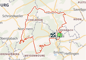
Randonnée Marche de 25 km à découvrir à Inconnu, Canton Mersch, Larochette. Cette randonnée est proposée par flip96.
Description
Extra trail A van Mullerthal Trail. Gestart in Larochette, parkeren nabij Rue de Mersch is gratis.
Opmerkingen? flip96@home.nl
Localisation
Pays :
Luxembourg
Région :
Inconnu
Département/Province :
Canton Mersch
Commune :
Larochette
Localité :
Unknown
Départ:(Dec)
Départ:(UTM)
299769 ; 5518228 (32U) N.
Commentaires