Randonnée Marche Troarn - nul... - Photo
 Jeff_314
Jeff_314

Utilisateur

© OpenStreetMap contributors
Longueur
Longueur
3,3 km
Altitude max
Altitude max
20 m
Dénivelé positif
Dénivelé positif
24 m
Km-Effort
Km-Effort  
3,6 km
Altitude min
Altitude min
4 m
Dénivelé négatif
Dénivelé négatif
24 m
Boucle
Boucle
Oui
Date de création :
2014-12-10 00:00:00.0
Dernière modification :
2014-12-10 00:00:00.0

(0 Avis)

Marche
Marche
59m
Difficulté : Facile

Scannez ce code QR pour ouvrir la randonnée dans l'application SityTrail

Application GPS de randonnée GRATUITE

Logo SityTrail SityTrail

IGN / Instituts géographiques

Télécharger SityTrail sur l'App Store Télécharger SityTrail sur Google Play

Logo SityTrail SityTrail World

Le monde est à vous

Télécharger SityTrail sur l'App Store Télécharger SityTrail sur Google Play Télécharger SityTrail sur Huawei AppGallery

À propos

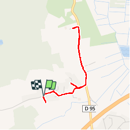
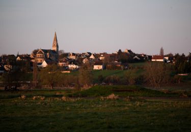
Randonnée Marche de 3,3 km à découvrir à Normandie, Calvados, Troarn. Cette randonnée est proposée par Jeff_314.

Description

impossible de passer... chiens, chemins privés..

Profil altimétrique

Localisation

Pays :
France
Région :
Normandie
Département/Province :
Calvados
Commune :
Troarn
Localité :
Unknown
Départ:(Dec)
Départ:(UTM)
705070 ; 5453908 (30U) N.

Randonnées à proximité

Randonnée Marche Saint-Ouen-du-Mesnil-Oger - st ouen du mesnil oger - Photo
Marche
nono1425

Marche

Très facile
(1)
Saint-Ouen-du-Mesnil-Oger, Normandie, Calvados, France
5,1 km | 5,5 km-effort
1h 20min
Non
Randonnée Cheval Goustranville - poteries petit parcours - Photo
Cheval
dartois

Cheval

Très facile
(1)
Goustranville, Normandie, Calvados, France
9 km | 9,6 km-effort
Inconnu
Oui
Randonnée V.T.T. Troarn - Autour de Troarn - Photo
V.T.T.
tracegps

V.T.T.

Facile
(2)
Troarn, Normandie, Calvados, France
5,3 km | 6,1 km-effort
45min
Oui
Randonnée Marche Troarn - Autour de Troarn - Photo
Marche
tracegps

Marche

Facile
Troarn, Normandie, Calvados, France
5,3 km | 6,1 km-effort
1h 30min
Oui
Randonnée Randonnée équestre Amfreville - Entre terre et mer  - Photo
Randonnée équestre
Delphine Besace

Randonnée équestre

Difficile
Amfreville, Normandie, Calvados, France
30 km | 33 km-effort
4h 24min
Oui
Randonnée Marche Touffréville - Du Calcaire aux Fossiles  - Photo
Marche
Manouchka3

Marche

Très facile
Touffréville, Normandie, Calvados, France
192 km | 214 km-effort
3h 50min
Non
Randonnée Marche Petiville - Les marais et l'île de Robehomme - Photo
Marche
neitag61

Marche

Difficile
Petiville, Normandie, Calvados, France
13,2 km | 14,7 km-effort
3h 15min
Oui
Randonnée V.T.T. Saint-Pair - la dernière avant la Guadeloupe  - Photo
V.T.T.
mikeleguerrier

V.T.T.

Facile
Saint-Pair, Normandie, Calvados, France
29 km | 31 km-effort
2h 6min
Oui
Randonnée V.T.T. Troarn - Les éoliennes de Chicheboville - Photo
V.T.T.
tracegps

V.T.T.

Moyen
Troarn, Normandie, Calvados, France
54 km | 59 km-effort
3h 0min
Oui


Fermer
Mes abonnements