Randonnée Vélo Embrun - Contre la montre EMBRUN-CHORGES - Photo

Contre la montre EMBRUN-CHORGES

 BLANCHET
BLANCHET

Utilisateur

© OpenStreetMap contributors
Longueur
Longueur
31 km
Altitude max
Altitude max
1285 m
Dénivelé positif
Dénivelé positif
895 m
Km-Effort
Km-Effort  
43 km
Altitude min
Altitude min
781 m
Dénivelé négatif
Dénivelé négatif
912 m
Boucle
Boucle
Non
Date de création :
2014-12-10 00:00:00.0
Dernière modification :
2014-12-10 00:00:00.0

(0 Avis)

Vélo
Vélo
2h05
Difficulté : Difficile

Scannez ce code QR pour ouvrir la randonnée dans l'application SityTrail

Application GPS de randonnée GRATUITE

Logo SityTrail SityTrail

IGN / Instituts géographiques

Télécharger SityTrail sur l'App Store Télécharger SityTrail sur Google Play

Logo SityTrail SityTrail World

Le monde est à vous

Télécharger SityTrail sur l'App Store Télécharger SityTrail sur Google Play Télécharger SityTrail sur Huawei AppGallery

À propos

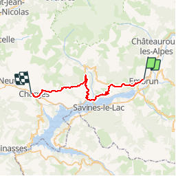
Randonnée Vélo de 31 km à découvrir à Provence-Alpes-Côte d'Azur, Hautes-Alpes, Embrun. Cette randonnée est proposée par BLANCHET.

Description


RECONNAISSANCE DU CIRCUIT CONTRE LA MONTRE DU 17/04/2013 LORS DU TOUR DE FRANCE.
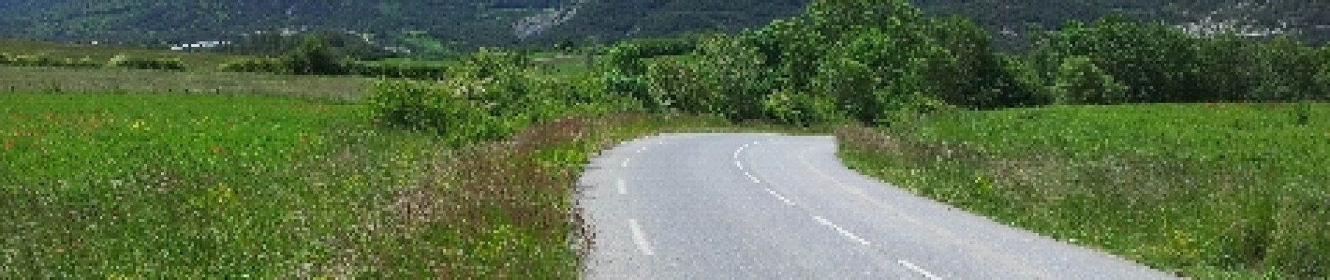
TRÈS PHYSIQUE,POUR MOI EN TOUT CAS!(A CAUSE DE MON AGE, PEUT-ÊTRE, ET MALGRÉ L 'ASSISTANCE ÉLECTRIQUE (VAE),
MAIS QUEL PANORAMA !
JE LE CONSEILLE VIVEMENT AUX CYCLISTES QUI SONT DANS LE COIN, ET POUR LES AUTRES,
S'IL N'Y A QU'UNE ÉTAPE A REGARDER A LA TÉLÉ, C'EST CELLE-LA!

Profil altimétrique

Photos

Localisation

Pays :
France
Région :
Provence-Alpes-Côte d'Azur
Département/Province :
Hautes-Alpes
Commune :
Embrun
Localité :
Unknown
Départ:(Dec)
Départ:(UTM)
301078 ; 4937826 (32T) N.

Randonnées à proximité

Randonnée Marche Embrun - Lac de l'Hivernet - Photo
Marche
gildascb

Marche

Facile
(1)
Embrun, Provence-Alpes-Côte d'Azur, Hautes-Alpes, France
10,6 km | 21 km-effort
3h 55min
Oui
Randonnée Marche Embrun - Mont Guillaume-Col de Chanté Perdrix-Lac de l'Hivernet(07-09-16) - Photo
Marche
Dervalmarc

Marche

Difficile
(2)
Embrun, Provence-Alpes-Côte d'Azur, Hautes-Alpes, France
15,4 km | 31 km-effort
7h 4min
Oui
Randonnée Marche Saint-Sauveur - 2012-08-07 Méale - Photo
Marche
Tchoubi

Marche

Difficile
(1)
Saint-Sauveur, Provence-Alpes-Côte d'Azur, Hautes-Alpes, France
8,3 km | 14,9 km-effort
3h 34min
Oui
Randonnée Marche Embrun - Mont Guillaume - Col de Trempa-Latz - 2671 - Photo
Marche
GUIDE
R@ph

Marche

Très difficile
Embrun, Provence-Alpes-Côte d'Azur, Hautes-Alpes, France
13,6 km | 28 km-effort
6h 20min
Oui
Randonnée Marche Embrun - Mt Guillaume - Lac de l'Hivernet - Photo
Marche
GUIDE
David25400

Marche

Difficile
Embrun, Provence-Alpes-Côte d'Azur, Hautes-Alpes, France
12,7 km | 28 km-effort
4h 8min
Oui
Randonnée Marche Embrun - lac de l hivernet - Photo
Marche
gibello

Marche

Facile
(1)
Embrun, Provence-Alpes-Côte d'Azur, Hautes-Alpes, France
9,4 km | 19,5 km-effort
4h 1min
Oui
Randonnée Marche Saint-André-d'Embrun - Boucle lac de Siguret et Chapelle Saint Roch - Photo
Marche
gildascb

Marche

Moyen
Saint-André-d'Embrun, Provence-Alpes-Côte d'Azur, Hautes-Alpes, France
6,7 km | 9,6 km-effort
2h 14min
Oui
Randonnée Marche Embrun - Mont Guillaume - Photo
Marche
Marco05

Marche

Difficile
Embrun, Provence-Alpes-Côte d'Azur, Hautes-Alpes, France
12,6 km | 26 km-effort
5h 55min
Oui
Randonnée Marche Saint-André-d'Embrun - pinée et vietnam 221021 - Photo
Marche
GUIDE
David25400

Marche

Très facile
Saint-André-d'Embrun, Provence-Alpes-Côte d'Azur, Hautes-Alpes, France
39 km | 50 km-effort
4h 23min
Non


Fermer
Mes abonnements