Randonnée Marche Ceillac - Tour du Queyras et variantes, du 21 juin au 5 juillet 2018 - Photo

Tour du Queyras et variantes, du 21 juin au 5 juillet 2018

 Pascalvedrin
Pascalvedrin

Utilisateur

© OpenStreetMap contributors
Longueur
Longueur
223 km
Altitude max
Altitude max
3163 m
Dénivelé positif
Dénivelé positif
16159 m
Km-Effort
Km-Effort  
439 km
Altitude min
Altitude min
1188 m
Dénivelé négatif
Dénivelé négatif
16160 m
Boucle
Boucle
Oui
Date de création :
2018-07-07 13:20:16.694
Dernière modification :
2018-07-10 15:18:59.115

(0 Avis)

Marche
Marche
--
Difficulté : Moyen

Scannez ce code QR pour ouvrir la randonnée dans l'application SityTrail

Application GPS de randonnée GRATUITE

Logo SityTrail SityTrail

IGN / Instituts géographiques

Télécharger SityTrail sur l'App Store Télécharger SityTrail sur Google Play

Logo SityTrail SityTrail World

Le monde est à vous

Télécharger SityTrail sur l'App Store Télécharger SityTrail sur Google Play Télécharger SityTrail sur Huawei AppGallery

À propos

Randonnée Marche de 223 km à découvrir à Provence-Alpes-Côte d'Azur, Hautes-Alpes, Ceillac. Cette randonnée est proposée par Pascalvedrin.

Description

Le Tour du Queyras, avec certaines variantes, le Tour du pain de Sucre, le Tour de la Font Sancte.

Profil altimétrique

Points d'intérêt

Point d'intérêt Pontechianale - 6 Bivouac - Photo
Pascalvedrin
PONTECHIANALE 
Point d'intérêt Abriès-Ristolas - 7 Refuge - Photo
Pascalvedrin
ABRIÈS-RISTOLAS 
Point d'intérêt Abriès-Ristolas - 8 Refuge - Photo
Pascalvedrin
ABRIÈS-RISTOLAS 
Point d'intérêt Cervières - 9 Refuge - Photo
Pascalvedrin
CERVIÈRES 
Point d'intérêt Château-Ville-Vieille - 10 Refuge - Photo
Pascalvedrin
CHÂTEAU-VILLE-VIEILLE 
Point d'intérêt Le Petit Jardin - 11 Refuge - Photo
Pascalvedrin
LE PETIT JARDIN 
Point d'intérêt Ceillac - 12 Bivouac - Photo
Pascalvedrin
CEILLAC 
Point d'intérêt Vars - 13 Refuge - Photo
Pascalvedrin
VARS 
Point d'intérêt Saint-Paul-sur-Ubaye - 14 Refuge - Photo
Pascalvedrin
SAINT-PAUL-SUR-UBAYE 
Point d'intérêt Ceillac - 1 Bivouac - Photo
Pascalvedrin
CEILLAC 
Point d'intérêt Saint-Véran - 2 Bivouac - Photo
Pascalvedrin
SAINT-VÉRAN 
Point d'intérêt Abriès-Ristolas - 4 Refuge - Photo
Pascalvedrin
ABRIÈS-RISTOLAS 
Point d'intérêt Bobbio Pellice - 5 Refuge - Photo
Pascalvedrin
BOBBIO PELLICE 
Point d'intérêt Molines-en-Queyras - 3 Refuge - Photo
Pascalvedrin
MOLINES-EN-QUEYRAS 

Localisation

Pays :
France
Région :
Provence-Alpes-Côte d'Azur
Département/Province :
Hautes-Alpes
Commune :
Ceillac
Localité :
Unknown
Départ:(UTM)
323649 ; 4948135 (32T) N.

Randonnées à proximité

Randonnée Marche Ceillac - Crêtes de Chambrettes - Photo
Marche
GUIDE
amiral13

Marche

Moyen
(1)
Ceillac, Provence-Alpes-Côte d'Azur, Hautes-Alpes, France
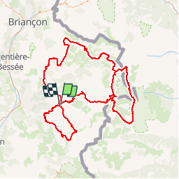
13,4 km | 26 km-effort
5h 53min
Oui
Randonnée Marche Ceillac - 05 Tour Font Sancte - étape 1 - Photo
Marche
Maryma

Marche

Très difficile
(1)
Ceillac, Provence-Alpes-Côte d'Azur, Hautes-Alpes, France
16,5 km | 36 km-effort
8h 9min
Non
Randonnée Marche Vars - 05 Tour Font Sancte - étape 2 - Photo
Marche
Maryma

Marche

Très difficile
(1)
Vars, Provence-Alpes-Côte d'Azur, Hautes-Alpes, France
19 km | 38 km-effort
8h 41min
Non
Randonnée Marche Ceillac - Ceillac - St Véran - Photo
Marche
GUIDE
romanceline

Marche

Moyen
Ceillac, Provence-Alpes-Côte d'Azur, Hautes-Alpes, France
13,5 km | 28 km-effort
7h 22min
Non
Randonnée Marche Ceillac - la pointe de la Saume (traversée) - Photo
Marche
GUIDE
amiral13

Marche

Difficile
Ceillac, Provence-Alpes-Côte d'Azur, Hautes-Alpes, France
15 km | 34 km-effort
6h 43min
Non
Randonnée Marche Ceillac - Lac Ste Anne et Tête de Girardin - Photo
Marche
GUIDE
amiral13

Marche

Moyen
Ceillac, Provence-Alpes-Côte d'Azur, Hautes-Alpes, France
14,4 km | 27 km-effort
5h 48min
Oui
Randonnée Marche Ceillac - lac Sainte Anne - Photo
Marche
griffet

Marche

Facile
(2)
Ceillac, Provence-Alpes-Côte d'Azur, Hautes-Alpes, France
10,7 km | 17,9 km-effort
5h 16min
Non
Randonnée Marche Ceillac - #1 Queyras 3j étape 1 Ceillac - Lac de Roue - Photo
Marche
Liobric

Marche

Très difficile
Ceillac, Provence-Alpes-Côte d'Azur, Hautes-Alpes, France
16,7 km | 33 km-effort
7h 34min
Non
Randonnée Marche Ceillac - Mon GR-58 - Photo
Marche
choumac08

Marche

Très difficile
Ceillac, Provence-Alpes-Côte d'Azur, Hautes-Alpes, France
138 km | 250 km-effort
56h 55min
Oui


Fermer
Mes abonnements